/
Countryside Access Design Standards Countryside Access Design Standards

Countryside Access Design Standards - PDF document

myesha-ticknor
myesha-ticknor . @myesha-ticknor
Follow
406 views
Uploaded On 2015-12-07

Countryside Access Design Standards - PPT Presentation

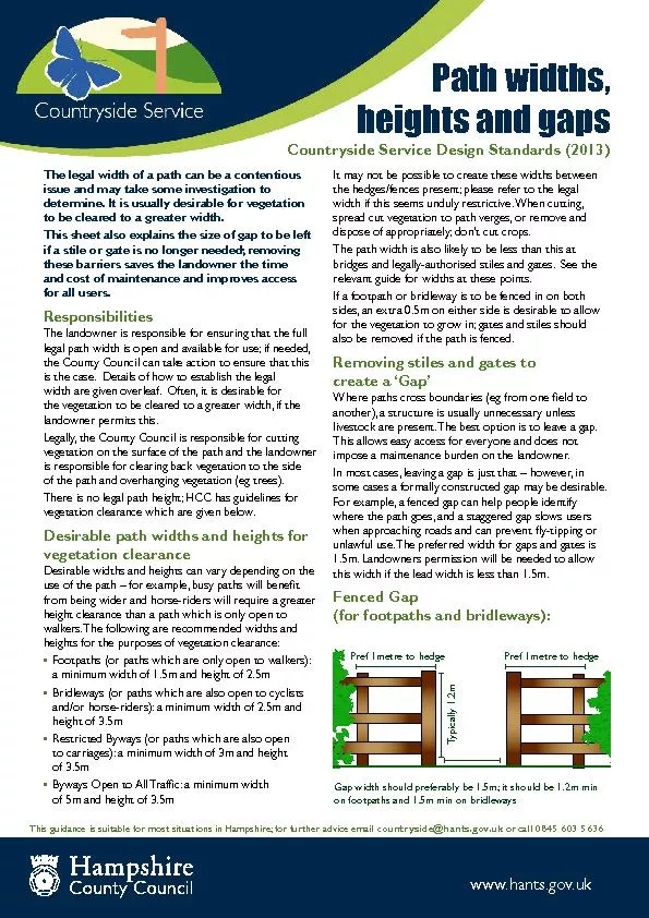
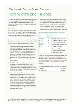
The width of a path can often be a contentious issue The following guidance is designed to help Ocers and Landowners understand how widths and heights on the public rights of way network should ID: 217539

The width path

Share:

Link:

Embed:

Download Presentation from below link

Download Pdf The PPT/PDF document "Countryside Access Design Standards" is the property of its rightful owner. Permission is granted to download and print the materials on this web site for personal, non-commercial use only, and to display it on your personal computer provided you do not modify the materials and that you retain all copyright notices contained in the materials. By downloading content from our website, you accept the terms of this agreement.


Presentation Transcript

Countryside Access Design Standards The width of a path can often be a contentious issue. The following guidance is designed to help Ocers and Landowners understand how widths and heights on the public rights of way network should be determined. Responsibilities It is an oence to reduce the width of a public right of way (PROW). The County Council has a responsibility to ensure that the entire width is open and available for public use. The County Council may act to remove any obstruction that reduces the width of a highway. Finding out the width of an existing Public Right of Way Listed below are a few ways to determine how wide an existing path should be in the event of a dispute: Check for widths recorded within the Denitive Statement for the path. There is provision within the Denitive Statement to record the width of the right of way and any limitation along it. Where the path has a recorded width within the Denitive Statement, this acts as conclusive evidence as to the width of the path. A copy of the Denitive Statement can be obtained from the Countryside Access Service and in many cases from the local Parish Council. Check for widths recorded in legal orders such Path Orders or Inclosure Awards. A request to the Denitive Map Team within the Countryside Access Service should be made to nd out if it is possible to view these documents. In cases where the path runs between two established boundary features, such as a hedge or a ditch, the whole width between them can be presumed to be available, so long as they were laid out in reference to the highway. Mapping evidence should be investigated, as it may be that ditches or hedges have been removed but the highway remains. The width of paths can be measured on maps using a scale rule, however caution should be maps, may vary in width. Arable land, eld edge paths and cross eld paths are subject to legal requirements. Please refer to the “Ploughing, crops and paths” leaet for guidance. In the event that a width cannot be established by any of the above means, the following table provides guidance as to what the County Council would normally expect to be available for public use. Recommended minimum path widths and heights Status Width (Metres) Exceptions Footpath 2 • Legally • Bridges • Established/Permanent natural Bridleway 3 Restricted Byway 3 Byway 5 * These are the minimum advised widths and may vary, dependant on local circumstance. An application can be made to the Countryside Access Service to include a width within the Denitive Statement. This procedure can only be processed with sucient supporting evidence. The minimum advised heights for PROW are as follows: Footpath 2.2 metres All other PROW 4 metres Further technical advice is available from the Countryside Access Service. Email: prow@kent.gov.uk Call: 0845 3450210 Write to: Kent County Council, Countryside Access Service, 2nd Floor Invicta House, Maidstone, Kent ME14 1XX Path Widths and Heights