/
Mars Science Laboratory Landing Site Mapping Mars Science Laboratory Landing Site Mapping

Mars Science Laboratory Landing Site Mapping - PowerPoint Presentation

natalia-silvester
natalia-silvester . @natalia-silvester
Follow
400 views
Uploaded On 2016-05-12

Mars Science Laboratory Landing Site Mapping - PPT Presentation

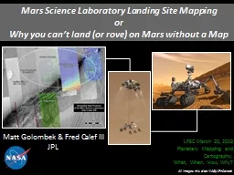
or Why you cant land or rove on Mars without a Map Matt Golombek amp Fred Calef III JPL All images this slide NASAJPLCaltech LPSC March 20 2013 Planetary Mapping and Cartography ID: 316776

gale golombek elevation 2012 golombek gale 2012 elevation msl rocks map crater surface amp canyon hirise landing material ctx cover thermal frequency

Share:

Link:

Embed:

Download Presentation from below link

Download Presentation The PPT/PDF document "Mars Science Laboratory Landing Site Map..." is the property of its rightful owner. Permission is granted to download and print the materials on this web site for personal, non-commercial use only, and to display it on your personal computer provided you do not modify the materials and that you retain all copyright notices contained in the materials. By downloading content from our website, you accept the terms of this agreement.


Presentation Transcript

Slide1

Mars Science Laboratory Landing Site MappingorWhy you can’t land (or rove) on Mars without a Map

Matt

Golombek & Fred Calef IIIJPL

All images this slide: NASA/JPL-Caltech

LPSC March 20, 2013

Planetary Mapping and Cartography,

What, When, How, Why?Slide2

VL1

MPF

Opportunity

VL2

Spirit

Landing Sites on Mars

Phoenix

Curiosity

Elevation Matters – Amount of Atmosphere to Slow Down

All Sites at Low Elevation

Latitude Matters – Solar Power; Thermal/power

Target Materials (e.g., ice)

MOLA is Base Map

Cartographic &

Inertial FramesSlide3

MSL Science Criteria

MSL Safety Criteria

MSL Science and Safety Constraints:

<25°

<100

m

0.5% CFA <7%

3/20/133

Golombek, Landing Site Selection

Remove these constraints

1

m

to 1000

mSlide4

DEMsComplete CTX DEM Coverage for Radar Interactions5-6 HiRISE DEMs to Cover EllipseKirk et al. [2011]Complete Slope Map (1-5 m)

HiRISE 1 m/elevation postings

CTX ~20 m/elevation postingsHRSC 50 m/elevation postingsGwinner

et al. [2010]

Hierarchical co-registration

Kim & Muller [2009] PSSSlide5

CTX DEMExample CTX DEM 25 m/elevation posting for Radar InteractionComplete Coverage of EllipseSlide6

Gale 1 m Slope Map

TouchdownStabilityTrafficabilitySlide7

9/29/10Golombek et al. Rocks7

VL2

South

North

PSP_1501_2280

400x400 pixels

124x124 meters

1.5 hectares

VL2

HiRISE

Changed Everything

Can

See Rocks Directly in

HiRISE

Correlate

Large Rocks in

HiRISE

with those Seen from Lander at All Landing SitesMeasure same size-frequency distribution at surface; follow models from surface

Golombek et al. [2008]Slide8

Gale Rock Map8

Golombek, MSL Data Products

Size-Frequency Distribution Rocks in 450 m binsFit to Model Size-Frequency Distribution for

CumulativeFractional Area from 1 - 40%

Calculate Probability of Success for All Rock Sizes

Rocks and Slopes-Touchdown Simulations

Golombek

et al. [2012]Slide9

Thermal Inertia

Gale

Thermal InertiaMaterial PropertiesFergason

et al. [2012]Slide10

Gale CraterBlue: Unconsolidated eolilan bedforms

Green: Eolian thin cover over indurated

alluviumYellow: Indurated alluviumRed: Indurated or cemented flat-lying unit

11/16/10

10

Surface Material PropertiesSurface Materials

Fergason

et al. [2012]Slide11

Blue=CraterPink=Mesa*=Probably Escapable**=Inescapable

Gale Potential Inescapable

HazardsGolombek et al. [2012]Slide12

Gale ID. 17**Crater, 400

m

diameter15 to

30° Slopes

Loose material on interior slopes, bedforms on floor

232084 m2137.548, -4.463

I

nescapableCoverage shows >15 ° slopes and loose material around entire crater interior

No obvious egress routeBedforms are likely traversable

Only 2 Inescapable

Craters

Cover 0.13% of Ellipse

Golombek

et al. [2012]Slide13

13

Cratered Plains – No obvious Mobility ConcernsDark DunesAppear FreshMany Exceed 30°Mobility

ImpedimentSample Strata HereDrive up CanyonHereCan Access Mineral Strata in CRISMCan drive up mound

Gale

Crater

Go To” Traversabilty

5/12/11Slide14

Gale Traverse Routes

Paolo

BelluttaIn Golombek et al. [2012]

From

TopographyRocks& Material Properties Slide15

Overview of Dunes

5/12/1115

Golombek et al. [2012]Slide16

SW Routes Through Dunes

5/12/1116

Golombek et al., MSL Data ProductsGolombek et al. [2012]Slide17

Traverse Routes in Lower Mound

First fence

Secondfence

Canyon 1Not Fan

First fence

Second

fence

Canyon 1Not Fan

Canyon 2

Clay layer

Canyon 2

Clay layer

5/12/11

17

Golombek et al., MSL Data ProductsSlide18

This completes the M. Golombek portion of the presentation. The presentation by F. Calef will be added to this and posted at a later date. (2013 April 2)