PPT-Coastal Emergency Risks Assessment (CERA)
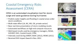
CERA is an automated visualization tool for storm surge and wave guidance during hurricanes Predicts water heights and flooding in coastal areas in realtime during
Download Presentation
"Coastal Emergency Risks Assessment (CERA)" is the property of its rightful owner. Permission is granted to download and print materials on this website for personal, non-commercial use only, provided you retain all copyright notices. By downloading content from our website, you accept the terms of this agreement. Download
Presentation Transcript
Transcript not available.