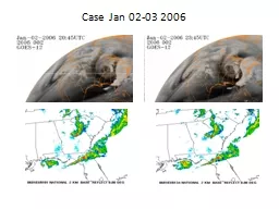
/
Case Jan 02-03 2006 250 MB Case Jan 02-03 2006 250 MB

Case Jan 02-03 2006 250 MB - PowerPoint Presentation

olivia-moreira
olivia-moreira . @olivia-moreira
Follow
347 views
Uploaded On 2019-02-07

Case Jan 02-03 2006 250 MB - PPT Presentation

010206 12Z 010306 00Z 500 MB 010206 12Z 010306 00Z 850 MB 010206 12Z 010306 00Z 00Z FFC Sounding 00Z TL H Sounding Low Lvl Moisture Advecting North ColdDry Mid Lvl Air Advecting East ID: 750870

jan 2006 wind degree 2006 jan degree wind sbcape 00z tornado county est time january kts 500 01z 12z

Share:

Link:

Embed:

Download Presentation from below link

Download Presentation The PPT/PDF document "Case Jan 02-03 2006 250 MB" is the property of its rightful owner. Permission is granted to download and print the materials on this web site for personal, non-commercial use only, and to display it on your personal computer provided you do not modify the materials and that you retain all copyright notices contained in the materials. By downloading content from our website, you accept the terms of this agreement.


Presentation Transcript

Slide1

Case Jan 02-03 2006Slide2

250 MB

01/02/06 12Z

01/03/06 00ZSlide3

500 MB

01/02/06 12Z

01/03/06 00ZSlide4

850 MB

01/02/06 12Z

01/03/06 00ZSlide5

00Z FFC Sounding

00Z TL

H Sounding

-- Low Lvl Moisture Advecting North --

-- Cold/Dry Mid Lvl Air Advecting East --Slide6

Parameters at 01Z

SBCAPE

750-1000 J/kg

0-3km Cape

125 J/kg

CIN

0 to -50 J/kg

LCL

500-600 m

LFC

1400-1500 m

LI

-5 to -6 C

500-700mb

LR

7-7.5 C/km

0-6km Shear

60-65 kts

0-3km Shear

40 kts

0-1km Shear

30-35 kts

0-3km Helicity

300-350 m^2/s^2

0-1km Helicity

300-350 m^2/s^2

Sfc Wind

10 kt @ 190

925mb Wind

20-25 kt @ 240

850mb Wind

20 kt @ 250

700mb Wind

25 kt @ 260

500mb Wind

35 kt @ 240

300mb Wind

100-105 kt @ 260Slide7
Slide8

SBCAPE / SFC WIND @ 01Z

SBCAPE / 925 MB WIND @ 01Z

Tornadoes occur on downwind side of SBCAPE axis.

Tornadoes occur along western edge of LLJ.

Tornado event

t

imes 0122Z and 0215ZSlide9

Conclusion

500mb shortwave initial kicker of thunderstorm development.Strong mid level lapse rates occur with dry/cold air from the west and low level moisture from the south.

Favorable parameters for tornadic supercellsTornadoes developed on downwind side of SBCAPE axis while entering western edge of LLJ.

Storms ran parallel to sfc speed convergence zone with unimpeded flow from the south into tail-end charlie

storm.Slide10

Jan 03, 2006: 0103Z 0.5 degreeSlide11

Jan 03, 2006: 0103Z 1.5 degreeSlide12

Jan 03, 2006: 0108Z 0.5 degreeSlide13

Jan 03, 2006: 0108Z 1.5 degreeSlide14

Jan 03, 2006: 0114Z 0.5 degreeSlide15

Jan 03, 2006: 0114Z 1.5 degreeSlide16

Jan 03, 2006: 0120Z 0.5 degreeSlide17

Jan 03, 2006: 0120Z 1.5 degreeSlide18

TIME (EST)

Johnson County Tornado January 2, 2006

Rotational Velocity (

In+Out

/2)Slide19

TIME (EST)

NROT Value

Johnson County Tornado January 2, 2006 Slide20

Jan 03, 2006: 0201Z 0.5 degreeSlide21

Jan 03, 2006: 0201Z 1.5 degreeSlide22

Jan 03, 2006: 0206Z 0.5 degreeSlide23

Jan 03, 2006: 0206Z 1.5 degreeSlide24

Jan 03, 2006: 0211Z 0.5 degreeSlide25

Jan 03, 2006: 0211Z 1.5 degreeSlide26

Jan 03, 2006: 0216Z 0.5 degreeSlide27

Jan 03, 2006: 0216Z 1.5 degreeSlide28

TIME (EST)

Jenkins County Tornado January 2, 2006

Rotational Velocity (

In+Out

/2)Slide29

TIME (EST)

NROT VALUE

Jenkins County Tornado January 2, 2006