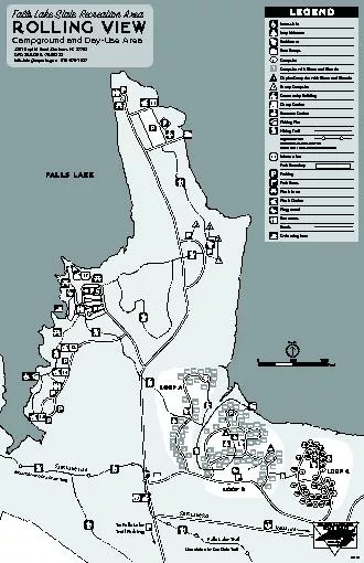
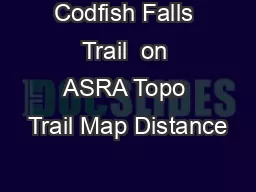
PDF-Codfish Falls Trail on ASRA Topo Trail Map Distance
Author : olivia-moreira | Published Date : 2015-05-17
7 miles to falls hours Difficulty Easy but trail is narrow at times with steep dropoffs to river Slope 0 avg 10 max see below Trailhead Parking N3859995 W12056420
Presentation Embed Code
Download Presentation
Download Presentation The PPT/PDF document "Codfish Falls Trail on ASRA Topo Trail ..." is the property of its rightful owner. Permission is granted to download and print the materials on this website for personal, non-commercial use only, and to display it on your personal computer provided you do not modify the materials and that you retain all copyright notices contained in the materials. By downloading content from our website, you accept the terms of this agreement.
Codfish Falls Trail on ASRA Topo Trail Map Distance: Transcript
7 miles to falls hours Difficulty Easy but trail is narrow at times with steep dropoffs to river Slope 0 avg 10 max see below Trailhead Parking N3859995 W12056420 Trailhead is on Ponderosa Way 6 miles south of Weimar From Auburn take I80 east to 2. Take the right fork Upper Trail hen you enter the woods Most of the climbing is in the first mile or so bringing you up to a series of viewpoints KEEP LEFT whenever the route seems unclear After the viewpoints the trail descends gently to an old ro The pEXP5-NT/TOPO and pEXP5-CT/TOPO(Catalog no. K9900-96) or available separately from Invitrogen to facilitate rapid, Cloning-mediated generation of expression constructs containing your configurati Goals. Define and describe topographic maps.. Define and describe an elevation profile.. Use a topographic map to create an elevation profile.. Describe how NASA probes create topographic maps that are used to create elevation profiles.. analysis . and . mapping . of Harford Glen for . resource . m. anagement . and . recreational . u. se. Natalie . Rymarz. Mentored by Mr. Jaime Alvarez and Mr. . Kierran. Sutherland. Introduction. Harford Glen was established as an environmental education center for Harford County Public Schools to educate students and members of the surrounding community. Beginning in 1990, Harford Glen hosted a residential program for fifth graders, engaging them in a wide variety of experimental environmental activities. A series of trails was established to make easier use of Harford Glen’s 340 acres of property. As time passed, the trails became increasingly overgrown with vegetation and the trail markings became faded. Additionally, the current trail map is outdated and inconsistent with trail markings, making it difficult to navigate through the property. This project goal was to create a trail map meeting the needs of resource managers and recreational users.. From Monitoring To Learning. . Chuck Podolak. Department of Geography & Environmental Engineering. The Johns Hopkins University. . 2011 . River Restoration Northwest Symposium. Collaborators. Peter Wilcock. Where I am going requires four USGS quad maps, can you make me a map that has my area on one map.”. Today, we have . topos. , aerials, satellite maps, hybrid . topophotos. . You can add private land boundaries, public land boundaries, US Forest Service Roads and Trials, GMU boundaries. We print on five different paper sizes, rolled or folded, waterproof or laminated, etc. . in a burn area. Vadose Zone Journal. Soil Science Society of America . Keep in mind: authors are looking to show that energy is affected by slope & aspect;. . that energy can predict soil depth;. SLIPS:. . Floors do not usually pose much hazard to their users unless conditions such as rain or snow create wet or icy surfaces. To prevent slips, watch where you are stepping. If the floor is wet, find a way to lessen the hazard. Post “Wet Floor” signs in the area until you mop up the excess water and place a mat in the entranceway. . Modulation of DNA topoisomerase II activity and
Received 6 May 1999Revised 13 July 1999Accepted 5 August 1999Correspondence to:H Lage
Topoisomerase II in melanoma489British Journal of Cancer (2000) 82 23
24
22
18
19
20
21
28
27
26
25
17
16
15
14
13
12
10
8
6
4
2
1
3
7
9
11
1
2
3
6
9
10
53
54
52
47
49
50
51
48
20
21
13
12
11
15
14
17
16
18
19
31
30
28
27
41
32
34
33
35
42
44
45
46
43
36
37
38
29
24 US Topo Federal Highway Administration Planning Glossary - http//wwwfhwadotgov/planning/glossary/glossarylistingcfmLock Chamber/SpillwayRock XWaterfallWellEarthen DamNonearthen DamLeveeRapidsHYDROGR Sac IR6KgoriBGHpAanamycinTOPOV5Stop6xHisKpn IXho IloxPTOPOV5Features of pUni/V5-His-TOPOand pUni-Blunt/V5-His-TOPOTOPO6xHis tag bases 542-559T7termTTThe modified T is either a 3pUni/V5-His-TOPO or pai kindly visit us at www.nexancourse.com. Prepare your certification exams with real time Certification Questions & Answers verified by experienced professionals! We make your certification journey easier as we provide you learning materials to help you to pass your exams from the first try. #Certification #Dumps #Certification_exam_Dumps
Certification Dump: Prove Your Expertise in IT and Software Technologies
Website: www.certpot.com
Certification dumps are collections of questions and answers used to prepare for a certification exam. They are often provided by third-party companies that specialize in exam preparation. Certification dumps are a valuable resource for anyone looking to prepare for a certification exam, as they provide an in-depth overview of the topics and concepts covered on the exam. Additionally, they are often updated with new and relevant information to ensure that the material is as fresh and up-to-date as possible. Certification dumps can save time and money by providing a comprehensive and convenient way to prepare for a certification exam
Download Document
Here is the link to download the presentation.
"Codfish Falls Trail on ASRA Topo Trail Map Distance"The content belongs to its owner. You may download and print it for personal use, without modification, and keep all copyright notices. By downloading, you agree to these terms.
Related Documents