Explore
Featured
Recent
Articles
Topics
Login
Upload
Featured
Recent
Articles
Topics
Login
Upload
Search Results for 'arcgis gis'
arcgis gis published presentations and documents on DocSlides.
The Geo-Web: Enabling GIS on the Internet
by pamella-moone
IT4GIS. Keith T. Weber, GISP. GIS Director. ISU-G...
Cultivating GIS at the Brooklyn Botanic Garden
by yoshiko-marsland
Kyle Heulitt. Advisor: . Professor . Ken . Tammin...
Nick Tonias, P.E. A Simplified Approach to Implementing GIS
by shangmaxi
1985. . The CEDRA Corporation is established. . ....
Extending ArcGIS using programming
by tawny-fly
David . Tarboton. GIS in Water Resources. 22 Octo...
Esri’s ArcGIS Enterprise
by luna
IT4GIS. Keith T. Weber, GISP. GIS Director. ISU-GI...
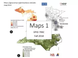
EPID 799C Fall 2018 Maps 1
by min-jolicoeur
https://geocompr.robinlovelace.net/adv-map.html. ...
Community-wide urban stormwater planning utilizing LiDAR, the WinSLAMM model and GIS
by cheryl-pisano
Dan Murphy. Rebecca Gronewold. UNI GeoTREE Center...
Introduction to ArcGIS Planetary Data Analysis
by min-jolicoeur
Peter Fawdon. Department of Earth and Planetary S...
How does a community utilize ESRI’s
by min-jolicoeur
ArcGIS Online functionality and incorporate. into...
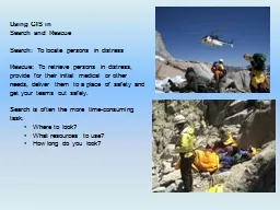
Using GIS in
by cheryl-pisano
Search and Rescue. Search: . To locate persons in...
Part I: GIS Tools for Water Planners
by lois-ondreau
and. Part II: Sierra Nevada Conservancy . GIS Wat...
GIS for Information Technology
by helene
Prepared by . Information . Technology Services . ...
User-Defined Layer Selection and Weighting for Initial Emergency Response Risk Mapping
by enjoinsamsung
Jonas Miller . Advisor: Fritz Kessler. Scenario. L...
GIS Data Collection Using
by ellena-manuel
Esri’s. . Collector App. Harkeerat Kang. 12.7....
GIS in Water Resources Midterm Review 2018
by cheryl-pisano
Blooms Taxonomy of Educational Objectives. 2. Com...
Coordinating Location Based Traffic
by kittie-lecroy
Count Data Collection Using . ArcGIS . Mobile App...
Using ArcGIS ModelBuilder for Conservation & Ag Drainag
by calandra-battersby
Janell Weiss. Nutrient Mgmt. Specialist/Ag Techni...
Regional GIS Users Group Meeting
by olivia-moreira
Wednesday, February 18. th. 2009. 10:00 AM - Noo...
An ISO 9001:2008 Registered
by freya
CMMI Maturity Level 3 Company. 1430 Spring Hill Rd...
GS6384 Vault is for More than Engineers: Integrating AutoCA
by luanne-stotts
Stephen Brockwell. President, Brockwell IT Consul...
Geographic Data Primitives
by myesha-ticknor
Large number:. Points, multiipoints, lines, polyl...
Campus Populations
by faustina-dinatale
Modeling and Visualizing the Changing . Concentra...
Using GIS to Compare all M&R Strategies for Asphalt Roa
by test
CEE 6240: GIS in Water Resources. By: Antonio Fue...
Module - V Integration of
by liane-varnes
GIS and Remote Sensing. Analysis and Presentatio...
Understanding GIS: An ArcGIS Pro Project Workbook (Understanding GIS, 4)
by majestykodi
It’s no secret that this world we live in can be...
Making NASA Data Sets Available
by stella
with . GIS-based Web-Applications . for Energy: PO...
GIS Software Support at Yale
by phoebe-click
Yale Map Department GIS Software Installation . L...
Marine Geospatial
by celsa-spraggs
Ecology Tools. Jason Roberts, Ben Best, Dan Dunn,...
APDM 6.0
by debby-jeon
ArcGIS Pipeline Data Model. Peter Veenstra. APDM ...
Hydrologic Application of Onion Creek
by alida-meadow
Revisit of the Halloween Flood from 2013. Juhn-Yu...
Marine Geospatial
by karlyn-bohler
Ecology Tools. Jason Roberts, Ben Best, Dan Dunn,...
Roberto Lucchi
by olivia-moreira
Esri. INSPIRE Discovery, View and Download and OG...
Using GIS to Analyze Movement of Tiger Sharks
by mitsue-stanley
Shark Tags. SPOT. http://www.hawaii.edu/himb/Reef...
GIS Tools For Assessing
by karlyn-bohler
Bicycle Suitability. Training Video. April 2012. ...
Assuring Connectivity in
by celsa-spraggs
an Electric Utility . GIS . Distribution . Model....
GIS Tools For Assessing
by test
Bicycle Suitability. Training Video. April 2012. ...
Prepared by: Jennifer McKee
by karlyn-bohler
With support from:. in partnership with:. Introdu...
Craig Robinson Harnessing Configuration
by jane-oiler
for web GIS Application Development. June 4, 2014...
Prepared by: Jennifer McKee
by karlyn-bohler
With support from:. in partnership with:. Introdu...
Hydro Networks in GIS Network model
by bery
Flow on Networks. Hydrologic networks. Linear refe...
Load More...