Explore
Featured
Recent
Articles
Topics
Login
Upload
Featured
Recent
Articles
Topics
Login
Upload
Search Results for 'arcgis model'
arcgis model published presentations and documents on DocSlides.
Extending ArcGIS using programming
by tawny-fly
David . Tarboton. GIS in Water Resources. 22 Octo...
WITHOUT LANGUAGE
by calandra-battersby
[ DEVELOPING GEO-PROCESSING MODELS USING ARCGIS M...
User-Defined Layer Selection and Weighting for Initial Emergency Response Risk Mapping
by enjoinsamsung
Jonas Miller . Advisor: Fritz Kessler. Scenario. L...
Community-wide urban stormwater planning utilizing LiDAR, the WinSLAMM model and GIS
by cheryl-pisano
Dan Murphy. Rebecca Gronewold. UNI GeoTREE Center...
Regional GIS Users Group Meeting
by olivia-moreira
Wednesday, February 18. th. 2009. 10:00 AM - Noo...
Hydro Networks in GIS Network model
by bery
Flow on Networks. Hydrologic networks. Linear refe...
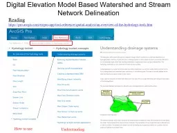
Digital Elevation Model Based Watershed and Stream Network Delineation
by myesha-ticknor
How to use. Reading. . https://. pro.arcgis.com/...
DEVELOPING AND ENHANCING LANDSAT DERIVED EVAPOTRANSPIRATION AND SURFACE ENERGY
by natalia-silvester
PRODUCTS. Landsat. . Science Team . Update. Towa...
Criteria for spent fuel site selection
by pamella-moone
Relating to:. Population Density. Transportation....
How does a community maintain a storm
by giovanna-bartolotta
water infrastructure database in ArcGIS . 9.3 usi...
APDM 6.0
by debby-jeon
ArcGIS Pipeline Data Model. Peter Veenstra. APDM ...
Food Store Location Analysis
by lindy-dunigan
Food Store Location Analysis Albuquerque New Mexi...
Marine Geospatial
by karlyn-bohler
Ecology Tools. Jason Roberts, Ben Best, Dan Dunn,...
Preparing input for the TOPKAPI (
by liane-varnes
TOPographic. Kinematic Approximation and Integra...
Hydrologic Application of Onion Creek
by alida-meadow
Revisit of the Halloween Flood from 2013. Juhn-Yu...
Marine Geospatial
by celsa-spraggs
Ecology Tools. Jason Roberts, Ben Best, Dan Dunn,...
Load More...