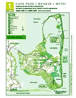
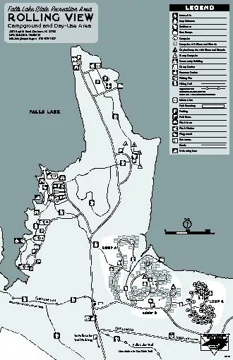
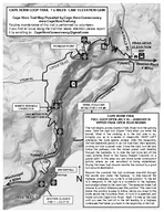
Take the right fork Upper Trail hen you enter the woods Most of the climbing is in the first mile or so bringing you up to a series of viewpoints KEEP LEFT whenever the route seems unclear After the viewpoints the trail descends gently to an old ro ID: 6466 Download Pdf
13 miles Blue 30 miles Restrooms 300 300 1000 1000 00 00 0 Feet Met Paved Ro Foot BridleFoot T Park Stream BuildingStructure Legend Brigade Blazed T White Restrooms Paved Ro Foot BridleFoot T Park Stream BuildingStructure Legend Jockey Society Pas Ri
Megan Cramer . Geosci. 010: Extra Credit #1. The Experience. The Billy Goat Trail is in Potomac, Maryland and is a 4.7 mile hike. My friends and I have been hiking the trail for years now, and return throughout the entire year. Upon visiting so many times, we have discovered more destinations a little off the trail’s route. Many of these sites we have found locks from the C&O canal that mark back all the way to the early 1900s. In this presentation I have included pictures I have posted on .
Little Wilson falls, Appalachian Trail, Elliotsville township, Maine (April). Little Wilson Falls in winter (December). Thompson Brook falls, lower tier of the upper falls, . Elliotsville Township, Maine (November).
BIKE TRAIL BRIDLE TRAIL STATE PARK LAND SAFETY ZONE PARK HEADQUARTERS MODERN CAMPGROUND RUSTIC CAMPGROUND RUSTIC CABIN ORGANIZATIONGROUP CAMP PICNIC AREA PICNIC SHELTER BEACH RESTROOM BOAT LAUNCH FISHING SITE FISHING PIER RIDING STABLES EQUESTRIAN C
This trail runs through much of the Cub Run and Rocky Run stream valleys The distance along the sec tions of trail shown on this map is approxi mately 25 miles The entire length of the trail has either an asphalt surface or is concrete All stream cr
Devyn. Parks. Between 1950-1994 Costa Rica had the fastest rate of deforestation in the western hemisphere (Borges-Mendez. , . Ramon., 2008). Caused by colonization schemes, agricultural expansion, and increased cattle ranching.
Yellow cliff/hope & carton Hill Home owners association. Intention. To all Property Owners of Yellow Cliff and Hope and Carton Hill:. We would like to encourage all property and land owners to review the attached slides to understand which areas of road will be improved in 2019. We utilized the .
Numerous trails suitable for short or extended hikes into Yellowstones backcountry begin in the Mammoth area. This guide introduces you to several hikes selected by park rangers. Always carry r
7 miles to falls hours Difficulty Easy but trail is narrow at times with steep dropoffs to river Slope 0 avg 10 max see below Trailhead Parking N3859995 W12056420 Trailhead is on Ponderosa Way 6 miles south of Weimar From Auburn take I80 east to 2
P a r k R o a d 1100 1180 1380 1320 1420 1480 1100 900 940 940 1280 1300 1400 1420 1560 1520 1500 1640 1620 1600 1580 1540 1440 1320 1340 1180 1200 1220 1240 1440 1460 1480 1400 1420 1560 1380 1520 15
Published bysherrill-nordquist
Take the right fork Upper Trail hen you enter the woods Most of the climbing is in the first mile or so bringing you up to a series of viewpoints KEEP LEFT whenever the route seems unclear After the viewpoints the trail descends gently to an old ro
Download Pdf - The PPT/PDF document "CAPE HORN TRAIL FULL LOOP OPEN JULY JAN..." is the property of its rightful owner. Permission is granted to download and print the materials on this web site for personal, non-commercial use only, and to display it on your personal computer provided you do not modify the materials and that you retain all copyright notices contained in the materials. By downloading content from our website, you accept the terms of this agreement.
© 2021 docslides.com Inc.
All rights reserved.