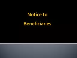
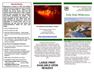
/
Special Notice Beginning in August of  the military us Special Notice Beginning in August of  the military us

Special Notice Beginning in August of the military us - PDF document

sherrill-nordquist
sherrill-nordquist . @sherrill-nordquist
Follow
405 views
Uploaded On 2015-06-03

Special Notice Beginning in August of the military us - PPT Presentation

Many of the artillery and mortar shells shot into the area for practice still exist In 1997 a highly trained crew surveyed the trail locations and known campsites for shells They found 15 some of which were still live All were exploded on site Many ID: 79675

Many the artillery

Share:

Link:

Embed:

Download Presentation from below link

Download Pdf The PPT/PDF document "Special Notice Beginning in August of t..." is the property of its rightful owner. Permission is granted to download and print the materials on this web site for personal, non-commercial use only, and to display it on your personal computer provided you do not modify the materials and that you retain all copyright notices contained in the materials. By downloading content from our website, you accept the terms of this agreement.


Presentation Transcript

Special Notice: Beginning in August of 1943, the military used the area for maneuvers and mountain training for World War II. Many of the artillery and mortar shells shot into the area for practice still exist. In 1997, a highly trained crew surveyed the trail locations and known campsites for shells. They found 15, some of which were still live. All were exploded on site. Many more may exist and they are dangerous. Since it is impossible to survey every acre of the wilderness, we ask that you follow the recommendations below for your own safety. Do not create new trails Camp at existing campsites. These usually have a fire ring and show bare ground around them. If you camp at a place without a fire ring DO NOT create one. Use a backpacker-type stove for your cooking needs and enjoy a night without a campfire. If you find an Unexploded Ordnance Do not touch, move or dig near or around the suspected ordnance. Identify the area on a map or by terrain feature. On the ground, from a distance away, you can point out the location by making an arrow using rocks or sticks, or hanging a bandana. Immediately contact Cheat-Potomac Ranger District Monday-Friday 304 257-4488 Monongahela National Forest Weekends, after hours 888 283-0303 Cheat-Potomac Ranger District, (304) 257-4488, Extension 0. Nondiscrimination Statement The U.S. Department of Agriculture (USDA) prohibits discrimination in all its programs and activities on the basis of race, color, national origin, sex, religion, age, disability, political beliefs, sexual orientation, or marital or family status. (Not all prohibited bases apply to all programs.) Persons re alternative means for communication of program information (Braille, large print, audiotape, etc.) should contact USDA's TARGET Center at (202) 720-2600 (voice and Monongahela National Forest 200 Sycamore Street Elkins, West Virginia 26241 (304) 636-1800 Telephone/TTY Wilderness in the Monongahela National Forest is part of the National Wilderness Preservation System. It is located in Grant, Randolph and Tucker Counties, West Virginia. The Dolly Sods Wilderness contains much of the Red Creek drainage and contains bog and Red Creek – Rocky Point – Big Stonecoal– Red Creek Trails: 514 – 554 – 513 – 514 Starts at: Laneville Cabin Length of loop: 8.5 miles Fords: 4 Fisher Spring – Red Creek – Big Stonecoal – Rocky Point – Red Creek – Fisher Spring Trails: 510 – 514 – 513 – 554 – 514 - 510 Starts at: Fisher Spring trailhead Length of loop: 10 miles Fords: 2 Red Creek – Breathed Mountain Big Stonecoal – Red Creek Trails: 514 – 553 – 513 – 514 Starts at: Laneville Cabin Length of loop: 13.5 miles Fords: 4 Red Creek – Little Stonecoal – Dunkenbarger – Big Stonecoal – Breathed Mountain – Red Creek Harman Trails: 511 – 524 - 525 Starts at: Blackbird Knob trailhead Length of Loop: 9.2 miles Fords: 6 Bear Rocks – Raven Ridge – Dobbin Grade Trails: 522 – 521 – 524 - 526 Starts at: Bear Rocks trailhead Length of Loop: 9.6 miles Fords: 5 Beaver Dam – Dobbin Grade – Beaver View – Raven Ridge Trails: 500 – 526 – 523 - 521 Starts at: Beaver Dam trailhead Length of Loop: 5.6 miles Fords: 3 Trail System: Dolly Sods Wilderness has 47 miles of trails, many of which follow old railroad grades and logging roads. Listed below are several possible loop hikes. Fords indicate streams that may be a problem to cross during high water events. There may be additional small stream crossings. Practice Leave No Trace outdoor ethics: do not build a camp within 200 feet of roads, streams and trails. 75 Trails: 510 – 508 – 560 – 75 Starts at: Fisher Spring trailhead Length of loop: 5.6 miles Fords: 0 Rohrbaugh – Wildlife – FR 75 – FR19 Trails: 508 – 560 – 75 Starts at: Rohrbaugh trailhead Length of loop: 7.7 miles Fords: 0 Red Creek – Little Stonecoal – Dunkenbarger – Big Stonecoal – Red Creek Trails: 514 – 552 – 558 – 513 – 514 Starts at: Laneville Cabin Length of loop: 7.5 miles Fords: 4