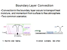
Dave Turner NOAA PECAN Science Workshop Norman Oklahoma 1921 September 2016 Background PECAN integrated sounding array PISA stations were unique component of the PECAN field experiment Desire to have thermodynamic and wind profiling remote sensors at each PISA site for high temporal r ID: 562187
Download Presentation The PPT/PDF document "Thermodynamic Profiling in the Boundary ..." is the property of its rightful owner. Permission is granted to download and print the materials on this web site for personal, non-commercial use only, and to display it on your personal computer provided you do not modify the materials and that you retain all copyright notices contained in the materials. By downloading content from our website, you accept the terms of this agreement.
Slide1
Thermodynamic Profiling in the Boundary Layer from the AERIs at the PISA Sites
Dave Turner
NOAA
PECAN Science Workshop
Norman, Oklahoma
19-21 September 2016Slide2
Background
PECAN integrated sounding array (PISA) stations were unique component of the PECAN field experiment
Desire to have thermodynamic and wind profiling remote sensors at each PISA site for high temporal resolution observationsAlso launched radiosondes at these sites at periodically during IOPsVarious universities and EOL contributed to each PISA
My objective was to have consistent profiling capability at each site, if possibleDOE’s ARM program provided AERI instruments at each PISA for thermodynamic profiling Ultimately, all 6 FPs and 2 (of 4) MPs had AERIs in themSlide3
Atmospheric Emitted Radiance Interferometer (AERI)
Measures downwelling IR spectra at high temporal and spectral resolution
(30 s, 1 cm-1)Invented by
Univ Wisconsin – MadisonHardened, automated instrument; self-calibratingCommercially available
25
µm
7.1
µm
10
µm
15
µm
Radiance [
mW
/ (m
2
sr
cm
-1)]
Wavelength [µm]
SGP, 8 Jul 2003PWV: 48.0 mm
NSA, 1 Mar 2004PWV: 1.3 mmSlide4
FP Locations
FP4: Minden
FP5: Brewster
FP3: Ellis
FP6: Hesston
FP2: Greensburg
FP1: ARM SGP SiteSlide5
MP3: SPARC
Univ
Wisc – Madison
AERI, DL, HSRL, tower, sonde
MP1: CLAMPS
OU / NSSL
AERI
, DL, MWR, tower,
sondesSlide6
AERIoe Data Availability per Day
FP2: Greensburg
FP3: Ellis
MP3: SPARC
MP1: CLAMPS (2-min)
FP6: Hesston
FP5: Brewster
FP4: MindenSlide7
AERIoe Data Availability per Day
FP2: Greensburg
FP3: Ellis
MP3: SPARC
MP1: CLAMPS (2-min)
FP6: Hesston
FP5: Brewster
FP4: MindenSlide8
AERIoe Data Availability per Day
FP2: Greensburg
FP3: Ellis
MP3: SPARC
MP1: CLAMPS (2-min)
FP6: Hesston
FP5: Brewster
FP4: MindenSlide9
AERIoe Data Availability per Day
FP2: Greensburg
FP3: Ellis
MP3: SPARC
MP1: CLAMPS (2-min)
FP6: Hesston
FP5: Brewster
FP4: MindenSlide10
AERIoe Data Availability per Day
FP2: Greensburg
FP3: Ellis
MP3: SPARC
MP1: CLAMPS (2-min)
FP6: Hesston
FP5: Brewster
FP4: Minden
Abnormal oscillation found in FP1 System – still working to resolve thisSlide11
Two Versions
of the Retrieval AlgorithmNeed to retrieve thermodynamic profiles from the AERI-observed infrared radiance
Ill-posed problem (e.g., multiple solutions can yield obs)Original version in EOL archive: Release 1.5Noted some cases when retrieved profiles were
aphysicalDecided to use additional observations to better constrain solutionNew version in EOL archive: Release 2.2Algorithm improvementsUses surface humidity measurement and RAP model “observation”; the latter constrains the middle-and-upper troposphere
Full error characterization for each retrieved profile in output file!Slide12
AERIoe Retrieval vs. Sonde
Sonde
AERIoe
v2.2AERIoe v1.5Slide13
AERIoe Retrieval vs. Sonde
Sonde
AERIoe
v2.2AERIoe v1.5Slide14
AERIoe Example from EllisSlide15
AERIoe Example from EllisSlide16
Comparison with SondesSlide17
Examples vs. Sondes
Sonde
AERIoe
v1.5
AERIoe v2.2Slide18
Summary
AERIs were deployed at all FPs and 2 MPsAERIoe retrievals performed at each site
Retrievals for FP2, FP3, FP4, FP5, FP6, MP1, and MP3 in EOL data archiveInstrument issues still need to be resolved at ARM SGP (FP1)Two versions of algorithm; please use Release 2.2Temporal resolution in archive is 5 min for most sites
Can reprocess to have maximum temporal resolution of 30-s, if desired (useful for rapidly changing events like bores)If you use AERIoe retrievals from FPs, please credit DOE!If any questions about these data (accuracy, resolution, uncertainties,
etc) please contact me.