/
Subpixel  Measurement of  Mangrove Canopy Closure from High Resolution RS Imagery Subpixel  Measurement of  Mangrove Canopy Closure from High Resolution RS Imagery

Subpixel Measurement of Mangrove Canopy Closure from High Resolution RS Imagery - PowerPoint Presentation

stefany-barnette
stefany-barnette . @stefany-barnette
Follow
353 views
Uploaded On 2020-01-07

Subpixel Measurement of Mangrove Canopy Closure from High Resolution RS Imagery - PPT Presentation

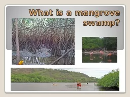
Subpixel Measurement of Mangrove Canopy Closure from High Resolution RS Imagery Minhe Ji 12 Jia Hu 1 Jing Feng 1 1 Key Lab of GIScience East China Normal Univ 2 GuangxiASEAN Marine Research ID: 772170

species mangrove pmoi spectral mangrove species spectral pmoi image moi pixel pixels mixture kandelia research subpixel closure high accuracy

Share:

Link:

Embed:

Download Presentation from below link

Download Presentation The PPT/PDF document "Subpixel Measurement of Mangrove Canop..." is the property of its rightful owner. Permission is granted to download and print the materials on this web site for personal, non-commercial use only, and to display it on your personal computer provided you do not modify the materials and that you retain all copyright notices contained in the materials. By downloading content from our website, you accept the terms of this agreement.


Presentation Transcript

Subpixel Measurement of Mangrove Canopy Closure from High Resolution RS Imagery Minhe Ji 1,2 , Jia Hu 1 , Jing Feng 1 1 Key Lab of GIScience , East China Normal Univ. 2 Guangxi-ASEAN Marine Research Center, GAS

Contents Research motivation and objectiveMangrove forests in Beilun Estuary Issues related to subpixel analysisResearch procedureResults and discussion Conclusions and future research

Research Motivation and Objective Coastal wetland inventory and monitoringCanopy closure for biomass estimationSpectral mixture of diverse materials at pixels Mixture of mangrove and background Mixture of different mangrove species communities Subpixel Analysis (SA) - unable to cope with diverse mangrove spectra Objective: develop a modified SA approach for better quantification of canopy closure (thus biomass)

Subpixel Classifier Assumes spatial average of spectral signatures from more than one surface materialDecomposes a wetland pixel, m, into mangrove (MC) and background (BC). Expresses their radiance contributions as linear additive in spectral bands, n (MC and BC assumed optically thick) R m [ n ] = ( k m [ n ] × MC [ n ]) + {(1 – k m [ n ]) × BC m [ n ]} Derives k m by iteratively subtracting fractions of candidate background spectra from the total pixel radiant spectrum ( R m )

Issues Related to Mangrove SA Multiple mangrove species in the same sceneSpectral mixture of more than one species within a pixelDiverse spectral characteristics of same species Spectral variation among same type mangroves of different locations within the same scene To a high degree, yet still somewhat overlapping Weak points of the subpixel classifier Incapable of deriving multiple materials at the same time Highly sensitive to spectral variation of the same material

DigitalGrobe’s Quickbird Multispectral (4-band, 2.44m) Panchromatic (0.61m)Acquired on 11-07-2005 Beilun Estuary Móng Cái Dong Xing Lais Island (alluvial plain), Vietnam

Acanthus ilicifolius Linn Kandelia obovata Major Mangrove Species Communities Aegiceras corniculata

Coexistence of Mangrove Types Acanthus ilicifolius Linn Aegiceras corniculata Kandelia obovata

Spectral Diversity of Same Species Kandelia North Kandelia Central Kandelia South

Spatial Variation of Same Species KNKC KS KN 0 1206.19 1411.18 KC 1206.19 0 479.757 KS 1411.18 479.7570 Transformed Divergence MatrixKNKC KSR-TotalKN89.1410.055.77263 KC6.3765.3017.31169KS4.4924.6676.92106C-Total26721952538Classification Error MatrixImplications to SASingle-MOI extraction – unable to cover entire spectra for the same species, leading to underestimationMultiple-MOI extraction – double counting overlapped portions among signatures of the same species, leading to overestimation

Combination Strategies pMOIs from multiple signatures of the same species were combined by taking the maximum as output: S_pMOI = Max(In_pMOI1, In_pMOI2, In_pMOI3) PMOIs derived from different species communities were combined as simple linear additive: P_pMOI = S1_pMOI + S2_pMOI + S3_pMOI Resulting per-pixel pMOI values were classified into eight (8) levels (starting from 20%, with a 10% increment).

Experimental Procedure Image preprocessingAutomatic environmental rectificationMOI signature training and extractionpMOI computation for image pixels Across signature combination of pMOI Pixel grouping into eight MOI levels. Accuracy assessment

Results: Single vs. Combined

Image draped on Eight Mangrove Levels

Accuracy Assessment Random stratified sampling of 180 pixels from 8+1 categories of the mangrove level mapVisual comparison between Quickbird Panchromatic image (as reference) and the classified map 155 of 180 sampled pixels agreed to the reference image, yielding an overall accuracy of 86.1% . Overall kappa = 0.84 % MOI 20-29 30-39 40-49 50-59 60-69 70-79 80-89 90-100 # B/W pixels3-45-678-910-111213-1415-16

Visual Comparison: MOI vs. Pan 5 by 5 pixel block Blown-up display Verification points overlaid on top of Pan-fused image 4 pixels → Level 1

Error Matrix of Mangrove Canopy MOI 0 1 2 3 4 5 6 7 8 Total Ua 0 22 4 22878.6112411770.6211321681.3311722085.041521788.251822090.0611611888.971202195.281222395.6Total221720201721192222180Pa10070.665.085.088.285.784.290.9100Overall classification accuracy = 86.1% Overall Kappa = 0.844

Conclusions and Future Research High-resolution RS provides great opportunities for better marine resource management, but the issue of spectral mixture remains.The improved SA approach useful for mangrove canopy closure mapping - satisfactory results generated from Quickbird high resolution multispectral data Lower end closure estimation rather flaw prone A more robust SA model need be developed to accommodate diverse spectral characteristics of mangroves.

Thank you ~ Questions are welcome mhji@geo.ecnu.edu.cn