/
GOES-16 ABI Cloud  and Moisture Imagery in GOES-16 ABI Cloud  and Moisture Imagery in

GOES-16 ABI Cloud and Moisture Imagery in - PowerPoint Presentation

tatyana-admore
tatyana-admore . @tatyana-admore
Follow
342 views
Uploaded On 2020-01-25

GOES-16 ABI Cloud and Moisture Imagery in - PPT Presentation

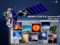
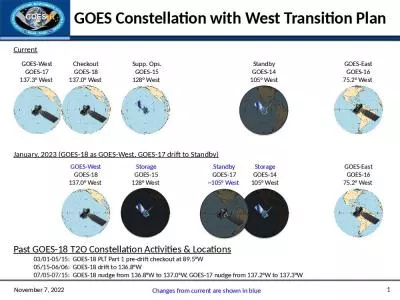
GOES16 ABI Cloud and Moisture Imagery in NWS NWS Update for FullValidation PSPVR June 1 2018 1 GOES16 Cloud and Moisture Imagery in AWIPS2 and NAWIPS Fielded AWIPS2 baseline handles ingestdecodestoredisplaypurge ID: 773781

Share:

Link:

Embed:

Download Presentation from below link

Download Presentation The PPT/PDF document "GOES-16 ABI Cloud and Moisture Imagery ..." is the property of its rightful owner. Permission is granted to download and print the materials on this web site for personal, non-commercial use only, and to display it on your personal computer provided you do not modify the materials and that you retain all copyright notices contained in the materials. By downloading content from our website, you accept the terms of this agreement.


Presentation Transcript

GOES-16 ABICloud and Moisture Imagery in NWS NWS Update for Full-Validation PS-PVR June 1, 2018 1

GOES-16 Cloud and Moisture Imagery in AWIPS-2 and N-AWIPSFielded AWIPS-2 baseline handles ingest/decode/store/display/purge of ABI ImageryAll ABI channels, all sectors (AWIPS derives RGBs and channel differences)WFOs/RFCs/RHQs receive SCMI for AWIPS-2 via SBN (since March 2, 2017) Examples are shown in the following slides (AWIPS-2/CAVE screenshots) Fielded N-AWIPS baseline handles ingest and display of ABI ImageryAll channels, all sectorsProjected McIDAS Area filesNCEP Centers receive CMI (for AWIPS and N-AWIPS) via GRB, with SBN as backup (since March 1, 2017) Backup slides summarize current NWS ABI product posture 2

AWIPS-2 Visualization and Exploitation16+ months of evolutionary improvements of GOES-16 ABI processing and rendering in NWS Satellite Enhancement Team (SET) review and approval processCollaborative activity among NWS regional/field reps, cooperative institutes, NWS HQ (OBS/TOWR-S Team) and GOES-R Program Office Defined menu structures, enhancement tables, RGB and difference definitions Orderly deployment of 15 “RPM” updates to regional and national forecast officesOBS/TOWR-S team coordinates and executes agile RPM process which accelerates changes into AWIPS (with baseline incorporation once functionality stabilizes)AWIPS/N-AWIPS refinements and training continue 3

4 Exploitation of GOES-16 ABI Mesos in NWS Initial process and tool for meso exploitation developed prior to GOES-16 T2O Meso Domain Scheduler (MDS, also known as Meso Mission Manager, MMM) encourages and facilitates meso collaboration and utilization Standard Operating Procedure documents mission priorities and the NESDIS/NWS meso -request process NWS Governance of ABI/ Meso process successfully transitioned to NWS Operations Division (Spring 2018) MDS/MMM tool and process supported by OBS/TOWR-S team Process evolution continues

AWIPS example: 0.64µm East Full Disk 5

AWIPS example: 0.64µm Mesoscale Sectors 6

AWIPS example: Split Water Vapor Channel Difference 7

AWIPS example: Air Mass RGB 8

Noteworthy Items (1 of 2)SCMI projected 3.9µm (band 7) Imagery: Cold Pixels appear next to very hot pixels (NWS OTE TTR 36)Streaky lines (“striping”) (NWS OTE TTR 18). NESDIS is aware and working. Received numerous requests to extend the Northern ECONUS farther northwardRelocation from 89.5 deg. to 75.2 deg provided better coverage just north of CONUSProjected imagery is sometimes degraded (shows significant pixelation) in basin-wide views, but disappears upon zoom-in, and warrants further investigationNWS internal issue, will be worked within AWIPS 9

Air Mass RGB (May 2018 Fixed Grid Sample) Example of striping shown in Air Mass RGB, based upon fixed grid sample tiles10

Noteworthy Items (2 of 2)“Checkerboard” display occurs in AWIPS for (non-Full Disk) channel differences and RGBs utilizing bands of differing spatial resolution RGBs impactedDay Convection (see next slide)CIMSS Natural ColorChannel Differences impactedSplit Fire (2.2-1.6µm)Split Snow (1.6-0.64µm) Split Vegetation (0.64-0.87µm) 11

Day Convection RGB (SCMI Fixed Grid Samples) Current spatial alignment of tiles results in “checkerboard” in AWIPS for (non-Full Disk) channel differences when channel resolutions vary For derived parameters to work, tiles must align spatiallyTile size must vary as a function of spatial resolution1024x1024 (0.5km) should correspond to a 512x512 (1km), which should correspond to a 256x256 (2km) tileAll need the same northwest pixel origin, with appropriate resolution-based offset 12 AWIPS/CAVE Screen Shot - “Checkerboard” Problem

Summary AssessmentGOES-16 ABI imagery is successfully operational in NWS NWS/OPPSD GOES-16 Operational Test and Evaluation (OT&E) Team conducted assessment, gathered feedback, summarized/reported results, and their Test Review Group voted to recommend SCMI for operational deployment on April 26, 2018NWS requests continued GOES-R Program attention on GOES-16 ABI fixed grid transition, correction of “checkerboard” issue, and other product refinements 13

Thanks! Questions? 14

Back-up Slides Current NWS GOES-16 ABI Product Posture(excerpted from OBS/TOWR-S update slides) 15

16

17

18

19