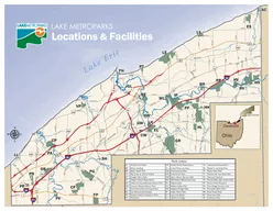
9 13 Green Mtn 109 Rickerts Pass Sheep 32 Sheep 100 15 Junction Mtn 85 Sheep 14 Hogs Back 41 Threepoint Creek 50 Threepoint Creek 38 08 09 Sheep River Falls Death Valley Loop 20 Ford Creek 107 Nihahi 24 Nihahi Ridge 22 Little Elbow Equestrian 30 Big ID: 11650 Download Pdf
Branch Chagrin River E Branch Chagrin River E Branch Chagrin River Corporation Ditch Jordan Creek Grand River East Creek Grand River Grand River Bates Creek Grand River Paine Creek Kellogg Creek Arcola Creek Paine Creek Big Creek Grand River 90 90 4
Projection Transverse Mercator Datum NZGD 2000 Map prepared by Geopatial Services 22Apr13 Haast Roar Blocks Overview Map 1 of 2 10 20 Kilometres Legend Balloted blocks Open blocks Freehold land No aircraft access
4 River Valley Civilizations. Fertile Crescent – Mesopotamia. Tigris. Euphrates. Egyptian Civilization. Nile River Valley (upper and lower Nile). Indus River. Harrapan. Mohen-jo Daro. Hwang He . Yellow River later civilizations focused on both Yangtze and Yellow River.
Water Quality Management Plan for 2012 Water Year. Provo River and. . Jordanelle. & Deer Creek Reservoirs. Projects in the Watershed. Wasatch County Development Review. . Stillwater Various plan approvals.
Global Studies 9. Mrs. Hart and Mrs. Bernier. Geography of India. India is a . sub-continent . that extends southward from mainland Asia into the Indian Ocean.. Geography of India. India is surrounded on the north by the Hindu Kush and Himalayan Mountains, which .
4 Regions!. City-States in Mesopotamia. Egypt & Nile River. Indus Valley. China. Common Characteristics ??. Water!!. Deserts of river cultures short on resources. River Valley Civilizations. Opportunity to adapt environment.
ANCIENT MESOPOTAMIA. Oldest known civilization. Cradle of Human Civilization. Old Testament . Nebuchadnezzar. Ziggurat (right). Hanging gardens. Geography. This civ rose in the valleys between the Tigris and Euphrates rivers..
Baseflow. for the Midwestern United States. http://www.tcdailyplanet.net/sites/tcdailyplanet.net/files/Rust belt_jpg_full_600.jpg. by. Catherine Konieczny, Joshua . Galster. Department of Earth and Environmental Science, Montclair State University.
Base Flood Elevation. Kate Marney. CE 394. Statistics in Water Resources. Introduction. HEC Statistical Software Package. Bulletin 17B analysis. National Academies Study Conclusion:. Sampling error does not vary with topography, drainage area, or landscape type.
Mr. Pentzak. Level One Individuals & Societies . Spring 2016. Name at least three things Mesopotamia had in common with Ancient Egyptian Civilization. We are about to study another ancient civilization. Make some predictions about this civilization (starting points: geography, religion, matriarchal vs. patriarchal, social structures, etc.) .
9 13 Green Mtn 109 Rickerts Pass Sheep 32 Sheep 100 15 Junction Mtn 85 Sheep 14 Hogs Back 41 Threepoint Creek 50 Threepoint Creek 38 08 09 Sheep River Falls Death Valley Loop 20 Ford Creek 107 Nihahi 24 Nihahi Ridge 22 Little Elbow Equestrian 30 Big
Download Pdf - The PPT/PDF document "Big Elbow River Sheep River Death Valley..." is the property of its rightful owner. Permission is granted to download and print the materials on this web site for personal, non-commercial use only, and to display it on your personal computer provided you do not modify the materials and that you retain all copyright notices contained in the materials. By downloading content from our website, you accept the terms of this agreement.
South Glasgow CreekMac CreekLittle Elbow RiverMist CreekJunction CreekRock CreekQuirk CreekVolcano CreekWare CreekGorge CreekThreepoint CreekBig Elbow RiverSheep RiverDeath Valley CreekHighwood River 549 546 40 66 549 0.91.3Green Mtn 10.9Rickerts PassSheep 3.2Sheep10.01.5Junction Mtn 8.5Sheep1.4Hogs Back4.1Threepoint Creek 5.0Threepoint Creek 3.80.80.9DeathValleyLoop2.0Ford Creek10.7Nihahi2.4NihahiRidge2.2Little ElbowEquestrian3.0Big Elbow3.9Big Elbow4.4Big Elbow11.24.0TombstoneLakes 3.71.0ElbowPass6.7Mist Creek13.2WhiskeyLake 1.4BluerockCreek 9.74.42.7VolcanoCreek 4.7VolcanoLink 3.21.4GorgeWareConnector2.7VolcanoSouth2.71.51.0GorgeCreek5.0SouthGorgeCreek5.3IndianOils4.7IndianOils3.0Sheep6.7WareCreek3.6WareCreek6.7WareCreek3.8DeathValley4.91.5DeathValley4.2PineRidge7.9Sheep1.6Price Camp2.71.7Price Camp2.7Meadow2.30.89999 Trail4.09999 Trail2.8Threepoint Creek 3.5North Fork5.40.5VolcanoCreek8.1VolcanoSouth 2.3ThreepointMtn 9.82.1 0.41.10.30.70.2PowderfaceRidge6.9Fordknoll2.2Wildhorse15.8Curley Sand3.60.3Sheep12.3WindyPoint3.20.8LongPrairieRidge2.1DeathValley1.40.7ForanGrade3.20.61.5LittleElbow7.4GorgeCreek3.1 0.50.81.40.91.20.46.70.61.40.51.0 N 2km4km Sheep Valley Trails Threepoint MountRaeMountWareMountRoseMountRemus MountQuirk MountMcNabbMountDysonMountBurns BandedPeakMountRomulus MistMountainMountLipsett MountHoman MountGlasgow MountBarwell MountTyrwhitt StormMountainGreenMountainMountCornwallMountFullerton ElpocaMountainCougarMountainStorelkMountainPyriformMountainJunctionMountainBluerockMountain AllsmokeMountainTombstoneMountainGibraltarMountainThreepointMountainMissinglinkMountainForgetmenotMountain Trail YOU ARE HERE RoadStreamDistance in kmParking 0.3 Camping Day UseWinter GateBridgeGroup CampingParkOce ProvincialWildland Provincial ParkProvincial Recreation Area
© 2021 docslides.com Inc.
All rights reserved.