/
Easy Going Route Cookham Introduction This easy going Easy Going Route Cookham Introduction This easy going

Easy Going Route Cookham Introduction This easy going - PDF document

trish-goza
trish-goza . @trish-goza
Follow
497 views
Uploaded On 2015-06-06

Easy Going Route Cookham Introduction This easy going - PPT Presentation

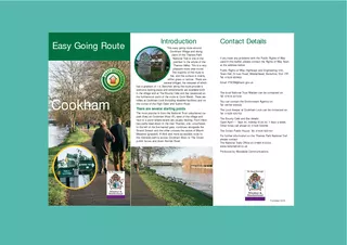
This is a very pleasant route yearround The majority of the route is flat and the surface is mainly either grass or tarmac There are several bridges the steepest of which has a gradient of 14 Benches along the route provide a welcome resting place a ID: 81190

This very

Share:

Link:

Embed:

Download Presentation from below link

Download Pdf The PPT/PDF document "Easy Going Route Cookham Introduction Th..." is the property of its rightful owner. Permission is granted to download and print the materials on this web site for personal, non-commercial use only, and to display it on your personal computer provided you do not modify the materials and that you retain all copyright notices contained in the materials. By downloading content from our website, you accept the terms of this agreement.


Presentation Transcript

EASY ACCESS Easy Going RouteCookham IntroductionThis easy going route aroundCookham Village and alongNational Trail is one of theprettiest in the whole of theThames Valley. This is a verypleasant route year-round.The majority of the route iseither grass or tarmac. There arethe route provide awelcome resting place and refreshments areavailable bothBar(seasonal) onthe furthermost point of the route at Cock Marsh. There arethe corner of the High Sreet and Sutton Road.The most popular is from the National Trust unsurfaced carpark (free) on Cookham Moor (P), west of the village andnext to a pond where swans are usually nesting. From thereto the left of the five barred gate, continues alongside theStrand Stream and the other crosses the centre of MarshMeadow (grassed). A third and more accessible route tothe riverside path is across Cookham Moor to The Crown If you have any problems with the Public Rights of Wayused in this leaflet, please contact the Rights of Way Teamat the address below:Public Rights of Way, Highways and Engineering Unit,Town Hall, St Ives Road, Maidenhead, Berkshire, SL6 1RF.Tel: 01628 683800Email: PROW@rbwm.gov.ukThe local National Trust Warden can be contacted on: Tel: 07818 427242You can contact the Environment Agency on:Tel: 08708 506506Tel: 01628 520752Open April 1 - Sept 30, midday til 22.30, 7 days a week.The Crown Public House: Tel: 01628 520163For further information on the Thames Path National TrailThe National Trails Office on 01865 810224.www.nationaltrail.co.ukProduced by Woodside Communications Published 06/08 THE VILLAGE ROUTE - B (2.5km)------ Permission may be sought from the landlord of TheCrown to use his car park to drop passengers; theon the Moor. Other parking in andaround the Village is limited.The tarmaced route downwhere the road gives wayCross a newly-built bridgeis before you. Before turning right at the sailing club, look out forthe craft Monarch; her plaque bears testimony to herrole as one of the thousands of small ships that made300,000 men from Dunkirk in the early days of WorldWar 2. Along the way look out for strangers to thesewaters. Besides the ever-present seagulls, terns havebeen seen fishing here; there will almost certainly beswans, ducks, moorhen, coots and the occasional greatcrested grebe. The riverbank is also a favoured mooringsite. At the willow turn right away from the river andfollow the route through the churchyard to the famous11th century Church of Holy Trinity, a much-lovedcentre of an active parish life and one-time home ofStanley SpencerÕs famous painting of The Last Supper. Continue through thechurchyard and gates intoChurch Gate which bringsyou into Cookham Village.Immediately opposite thereis the refurbished StanleySpencer Gallery, once aof SpencerÕs The Last Supper. Continue along the HighStreet, with the 14th century coaching inn, Bel and TheDragon on your right, and the 17th century KingÕs Armsantique dealers and, before that, thought to be whereStanley SpencerÕs grandparents lived. The names ofthe houses - The Old Apothecary, The Moorings - anda one-time butcherÕs tiled facia established 1775 - giveerstwhile villagers featured inSpencerÕs famousrestaurants andinteresting andretail shops.Forge MotorCompany, whichblacksmithÕs forge. VicarageThe CrownVillageTreeTo Church s ROGH S Whichever choice of route you took,the routeends here at the village memorial to men of thevillage who died in both World Wars. Ahead youwill see Berries Road,The Crown public house,and the National Trust car park. A 1:8 1:8 Scale:1:8,000 OADROOKTreeMarshdowlowTreeFERRYRIVER THAMES Thames LARGE CIRCULARROUTE - A (7.5km)------ Starting from the car park on CookhamMoor (A), or The Crown public house onBerries Road (B), you can take a circularroute along the open riverside, with theriverbank houses and marina of Bourneand footbridge to Bourne End you willpass a row of houses and ÔThe BountyÕfollow the river until it turns inland at asmall cluster of dwellings. Here a mid-field signpost will direct you southwardsacross a field to a RADAR gate.Continue along the well worn path andturn left at the foot of the escarpment.of the hill back towards Cookham.Passing through several immediately on your left there is anotherMeadow. On your left, notice a smallplantation of trees planted by Cookhamschool children to mark the millennium. Here too, a prominent local farmer andland-owner has funded and provided forsantuary, while the golf club on thebird boxes in woodlands bordering thecourse and is considered home territoryFrom here a grassed path cuts acrossThames Path National Trail. Alternativelythe Strand stream Ð one of the fewhabitats of the water vole in the county.and the National Trust car park. Some parts of the circular route can bemuddy and there are loose stones of upto 40mm. Some of the gates are quiteinteresting and worthwhile circuit. LOCK ROUTE - C(2.5km) you can continue to Cookham Lock. Starting from theWillow tree just north of the church, follow the surfacedriverside path eastwards beside a private house,underneath CookhamÕs Victorian road bridge andup over a ramped boardwalk (1:10). The paththen crosses the terrace of the Ferry Inn beforecontinuing up Ferry Lane to Odney Lane. Turnleft and at the end of the lane pass through aswing gate onto the bridge over Lulle Brooke.keeper on the number given overleaf. Here you willaccessible toilet. Cross another bridge to Sashes Island(beware the surface at ÔXÕ is extremely bumpywith a 1:6 gradient) turn right to the lockitself where tea is available onCliveden Cliff and Reach isavailable every day. Retrace yourroute back to the end of OdneyLane and to Cookham Village. Good ViewApprox GradientWoodland AreaWildlife Area Terrys Lane to Terrys LaneBourne End Station Terrys LaneThe Green Way Footpath Bourne End 1:4 1:6 1:6 1:8 1:4 1:10 1:8 1:4 1:10 ToiletVillage RouteCircular Route WCWCWC X NS Map Key