
LOCD-IN LOcation Corrections through DIfferential
Description: LOCD-IN LOcation Corrections through DIfferential Networks system Evan Dill Safety-Critical Avionics Systems Branch NASA Langley Research Center May 11th, 2022 Introduction Applications for mobile devices with built in Global Navigation
Related Topics
Download Presentation
"LOCD-IN LOcation Corrections through DIfferential" is the property of its rightful owner. Permission is granted to download and print the materials on this website for personal, non-commercial use only, and to display it on your personal computer provided you do not modify the materials and that you retain all copyright notices contained in the materials. By downloading content from our website, you accept the terms of this agreement.
Presentation Transcript
slide1. LOCD-IN
LOcation Corrections through DIfferential Networks system Evan Dill
Safety-Critical Avionics Systems Branch
NASA Langley Research Center
May 11th, 2022<br>
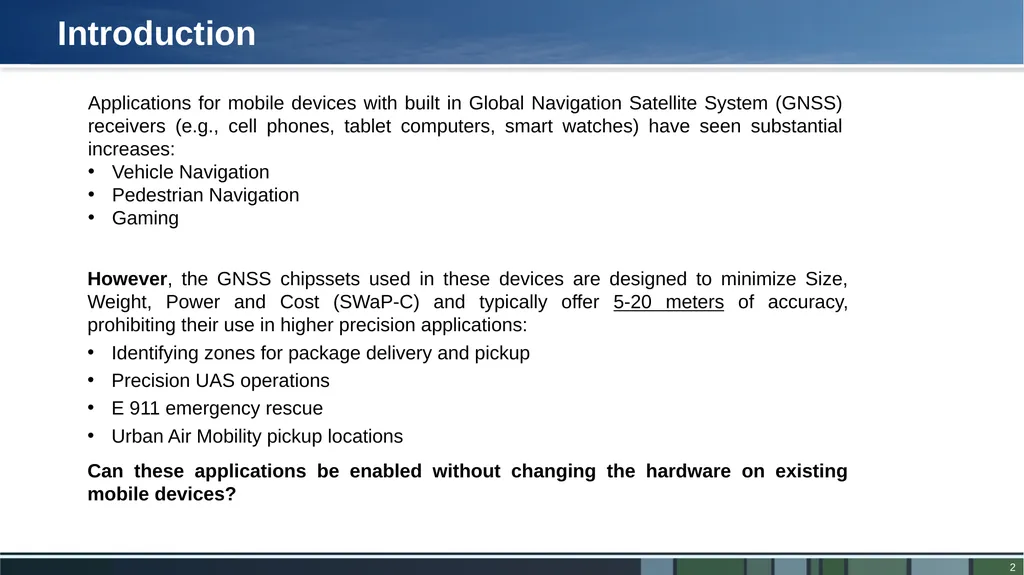
slide2. Introduction Applications for mobile devices with built in Global Navigation Satellite System (GNSS) receivers (e.g., cell phones, tablet computers, smart watches) have seen substantial increases:
Vehicle Navigation
Pedestrian Navigation
Gaming However, the GNSS chipssets used in these devices are designed to minimize Size, Weight, Power and Cost (SWaP-C) and typically offer 5-20 meters of accuracy, prohibiting their use in higher precision applications:
Identifying zones for package delivery and pickup
Precision UAS operations
E 911 emergency rescue
Urban Air Mobility pickup locations Can these applications be enabled without changing the hardware on existing mobile devices?<br>
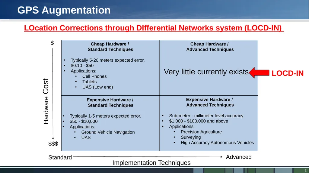
slide3. GPS Augmentation Hardware Cost Implementation Techniques $ $$$ Standard Advanced Cheap Hardware /
Standard Techniques
Typically 5-20 meters expected error.
$0.10 - $50
Applications:
Cell Phones
Tablets
UAS (Low end) Expensive Hardware /
Advanced Techniques
Sub-meter - millimeter level accuracy
$1,000 - $100,000 and above
Applications:
Precision Agriculture
Surveying
High Accuracy Autonomous Vehicles Expensive Hardware /
Standard Techniques
Typically 1-5 meters expected error.
$50 - $10,000
Applications:
Ground Vehicle Navigation
UAS Cheap Hardware /
Advanced Techniques
1-5 meters expected error.
$0.10 - $50
Applications:
UAS package delivery
Precision UAS operations
E911
UAM pick up locations LOCD-IN Very little currently exists LOcation Corrections through DIfferential Networks system (LOCD-IN)<br>
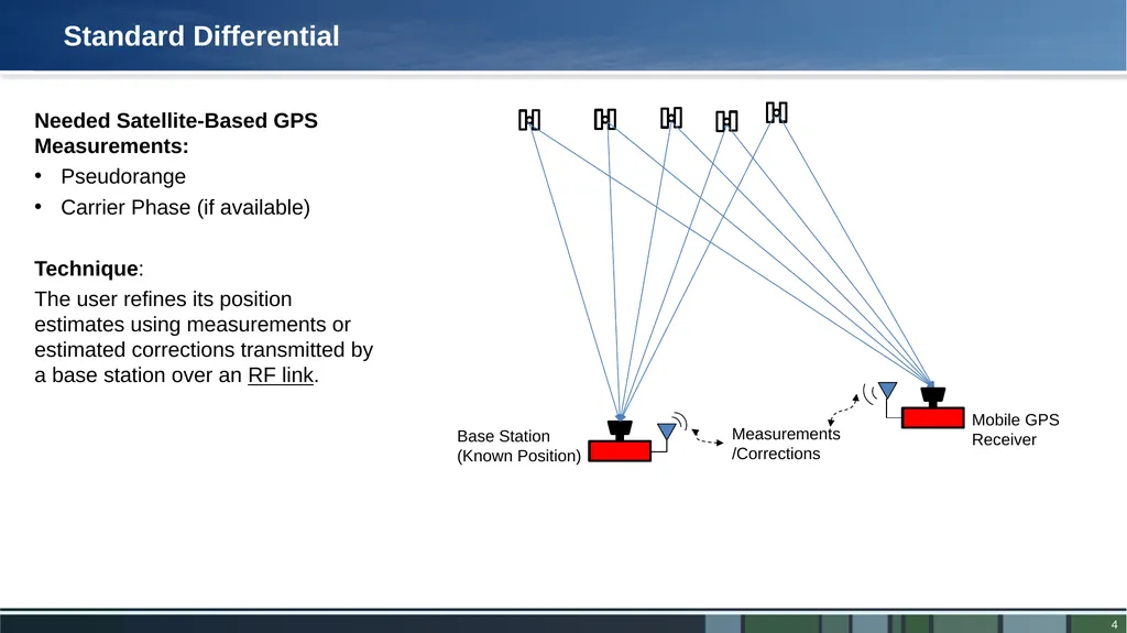
slide4. Standard Differential Measurements/Corrections Needed Satellite-Based GPS Measurements:
Pseudorange
Carrier Phase (if available)
Technique:
The user refines its position estimates using measurements or estimated corrections transmitted by a base station over an RF link.<br>
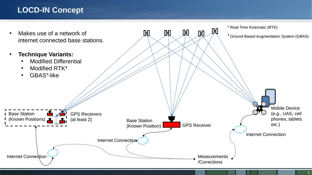
slide5. Mobile Device (e.g., UAS, cell phones, tablets etc.) Internet Connection LOCD-IN Concept Measurements/Corrections Makes use of a network of internet connected base stations.
Technique Variants:
Modified Differential
Modified RTK*
GBASŦ-like Internet Connection Internet Connection * Real-Time Kinematic (RTK)
Ŧ Ground Based Augmentation System (GBAS)<br>
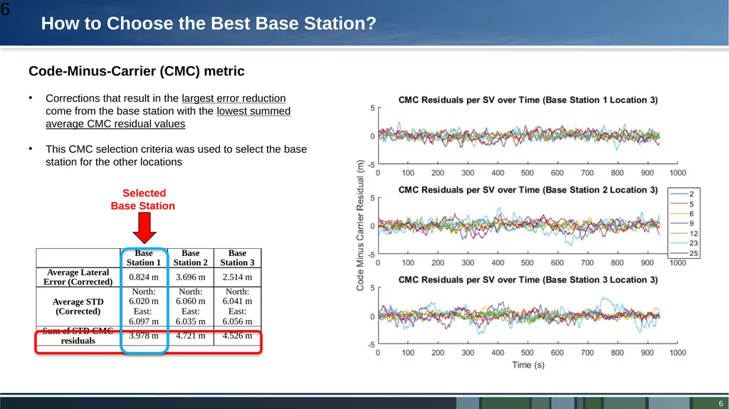
slide6. How to Choose the Best Base Station? 6 Code-Minus-Carrier (CMC) metric
Corrections that result in the largest error reduction come from the base station with the lowest summed average CMC residual values
This CMC selection criteria was used to select the base station for the other locations Selected Base Station<br>
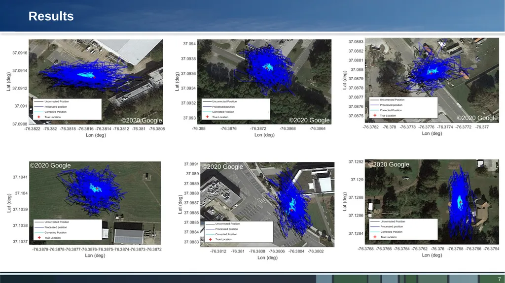
slide7. Results ©2020 Google ©2020 Google ©2020 Google ©2020 Google ©2020 Google ©2020 Google<br>
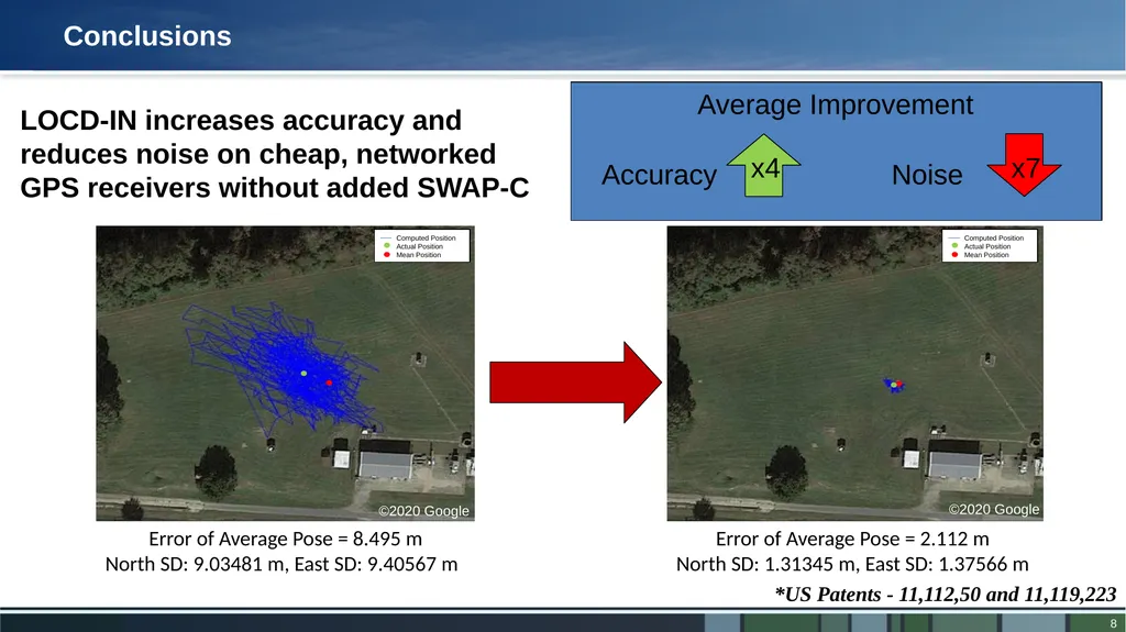
slide8. Conclusions Error of Average Pose = 8.495 m
North SD: 9.03481 m, East SD: 9.40567 m Error of Average Pose = 2.112 m
North SD: 1.31345 m, East SD: 1.37566 m *US Patents - 11,112,50 and 11,119,223 x4 Accuracy x7 Noise LOCD-IN increases accuracy and reduces noise on cheap, networked GPS receivers without added SWAP-C Average Improvement ©2020 Google ©2020 Google<br>
slide9. BACKUP<br>
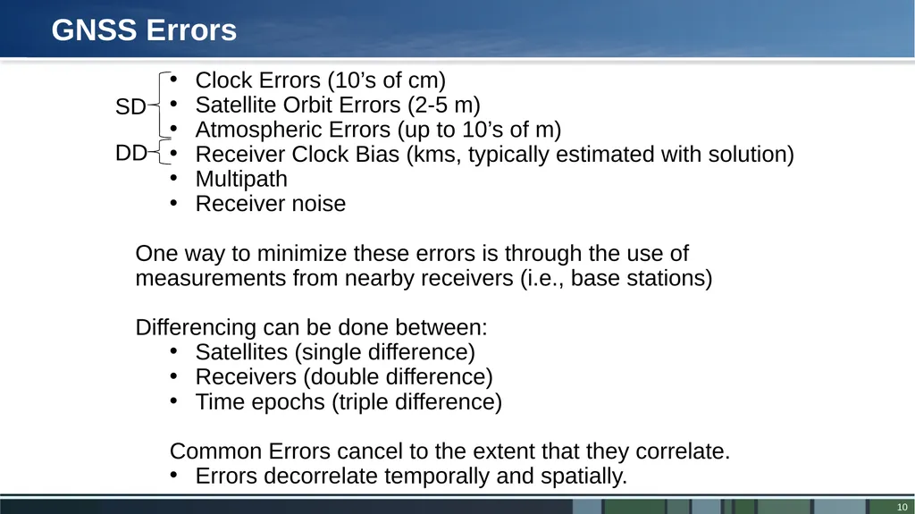
slide10. GNSS Errors SD DD Clock Errors (10’s of cm)
Satellite Orbit Errors (2-5 m)
Atmospheric Errors (up to 10’s of m)
Receiver Clock Bias (kms, typically estimated with solution)
Multipath
Receiver noise
One way to minimize these errors is through the use of measurements from nearby receivers (i.e., base stations)
Differencing can be done between:
Satellites (single difference)
Receivers (double difference)
Time epochs (triple difference)
Common Errors cancel to the extent that they correlate.
Errors decorrelate temporally and spatially.<br>
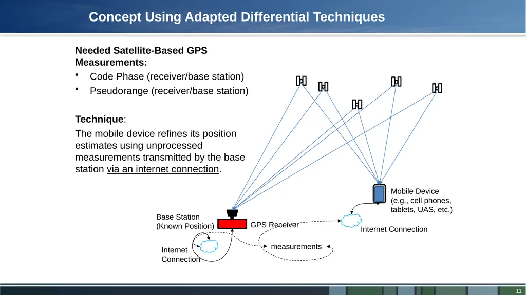
slide11. Needed Satellite-Based GPS Measurements:
Code Phase (receiver/base station)
Pseudorange (receiver/base station)
Technique:
The mobile device refines its position estimates using unprocessed measurements transmitted by the base station via an internet connection. Concept Using Adapted Differential Techniques measurements<br>
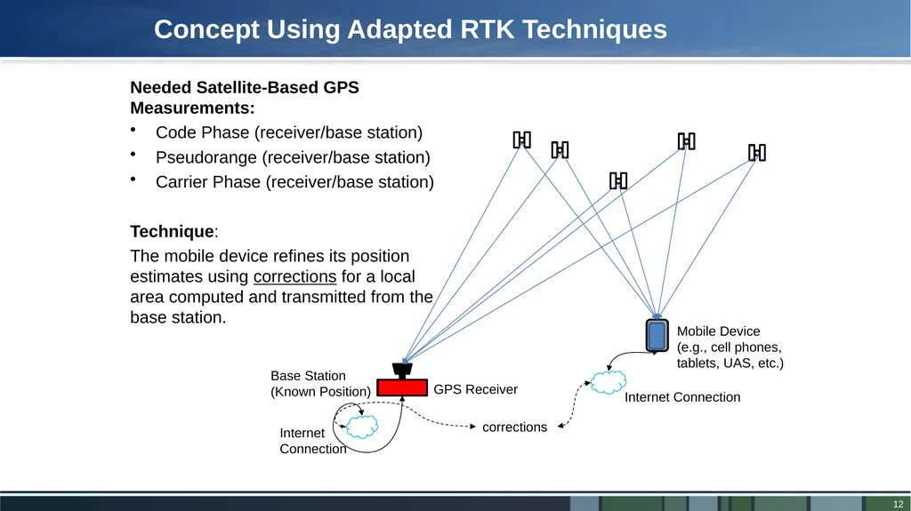
slide12. corrections Needed Satellite-Based GPS Measurements:
Code Phase (receiver/base station)
Pseudorange (receiver/base station)
Carrier Phase (receiver/base station)
Technique:
The mobile device refines its position estimates using corrections for a local area computed and transmitted from the base station. Concept Using Adapted RTK Techniques<br>
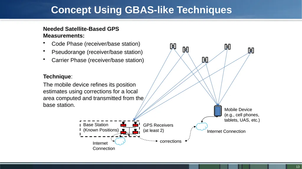
slide13. corrections Needed Satellite-Based GPS Measurements:
Code Phase (receiver/base station)
Pseudorange (receiver/base station)
Carrier Phase (receiver/base station)
Technique:
The mobile device refines its position estimates using corrections for a local area computed and transmitted from the base station. Concept Using GBAS-like Techniques<br>
LOcation Corrections through DIfferential Networks system Evan Dill
Safety-Critical Avionics Systems Branch
NASA Langley Research Center
May 11th, 2022<br>
slide2. Introduction Applications for mobile devices with built in Global Navigation Satellite System (GNSS) receivers (e.g., cell phones, tablet computers, smart watches) have seen substantial increases:
Vehicle Navigation
Pedestrian Navigation
Gaming However, the GNSS chipssets used in these devices are designed to minimize Size, Weight, Power and Cost (SWaP-C) and typically offer 5-20 meters of accuracy, prohibiting their use in higher precision applications:
Identifying zones for package delivery and pickup
Precision UAS operations
E 911 emergency rescue
Urban Air Mobility pickup locations Can these applications be enabled without changing the hardware on existing mobile devices?<br>
slide3. GPS Augmentation Hardware Cost Implementation Techniques $ $$$ Standard Advanced Cheap Hardware /
Standard Techniques
Typically 5-20 meters expected error.
$0.10 - $50
Applications:
Cell Phones
Tablets
UAS (Low end) Expensive Hardware /
Advanced Techniques
Sub-meter - millimeter level accuracy
$1,000 - $100,000 and above
Applications:
Precision Agriculture
Surveying
High Accuracy Autonomous Vehicles Expensive Hardware /
Standard Techniques
Typically 1-5 meters expected error.
$50 - $10,000
Applications:
Ground Vehicle Navigation
UAS Cheap Hardware /
Advanced Techniques
1-5 meters expected error.
$0.10 - $50
Applications:
UAS package delivery
Precision UAS operations
E911
UAM pick up locations LOCD-IN Very little currently exists LOcation Corrections through DIfferential Networks system (LOCD-IN)<br>
slide4. Standard Differential Measurements/Corrections Needed Satellite-Based GPS Measurements:
Pseudorange
Carrier Phase (if available)
Technique:
The user refines its position estimates using measurements or estimated corrections transmitted by a base station over an RF link.<br>
slide5. Mobile Device (e.g., UAS, cell phones, tablets etc.) Internet Connection LOCD-IN Concept Measurements/Corrections Makes use of a network of internet connected base stations.
Technique Variants:
Modified Differential
Modified RTK*
GBASŦ-like Internet Connection Internet Connection * Real-Time Kinematic (RTK)
Ŧ Ground Based Augmentation System (GBAS)<br>
slide6. How to Choose the Best Base Station? 6 Code-Minus-Carrier (CMC) metric
Corrections that result in the largest error reduction come from the base station with the lowest summed average CMC residual values
This CMC selection criteria was used to select the base station for the other locations Selected Base Station<br>
slide7. Results ©2020 Google ©2020 Google ©2020 Google ©2020 Google ©2020 Google ©2020 Google<br>
slide8. Conclusions Error of Average Pose = 8.495 m
North SD: 9.03481 m, East SD: 9.40567 m Error of Average Pose = 2.112 m
North SD: 1.31345 m, East SD: 1.37566 m *US Patents - 11,112,50 and 11,119,223 x4 Accuracy x7 Noise LOCD-IN increases accuracy and reduces noise on cheap, networked GPS receivers without added SWAP-C Average Improvement ©2020 Google ©2020 Google<br>
slide9. BACKUP<br>
slide10. GNSS Errors SD DD Clock Errors (10’s of cm)
Satellite Orbit Errors (2-5 m)
Atmospheric Errors (up to 10’s of m)
Receiver Clock Bias (kms, typically estimated with solution)
Multipath
Receiver noise
One way to minimize these errors is through the use of measurements from nearby receivers (i.e., base stations)
Differencing can be done between:
Satellites (single difference)
Receivers (double difference)
Time epochs (triple difference)
Common Errors cancel to the extent that they correlate.
Errors decorrelate temporally and spatially.<br>
slide11. Needed Satellite-Based GPS Measurements:
Code Phase (receiver/base station)
Pseudorange (receiver/base station)
Technique:
The mobile device refines its position estimates using unprocessed measurements transmitted by the base station via an internet connection. Concept Using Adapted Differential Techniques measurements<br>
slide12. corrections Needed Satellite-Based GPS Measurements:
Code Phase (receiver/base station)
Pseudorange (receiver/base station)
Carrier Phase (receiver/base station)
Technique:
The mobile device refines its position estimates using corrections for a local area computed and transmitted from the base station. Concept Using Adapted RTK Techniques<br>
slide13. corrections Needed Satellite-Based GPS Measurements:
Code Phase (receiver/base station)
Pseudorange (receiver/base station)
Carrier Phase (receiver/base station)
Technique:
The mobile device refines its position estimates using corrections for a local area computed and transmitted from the base station. Concept Using GBAS-like Techniques<br>