Petrographic Provinces Rajnikant patidar Department of Geology M.L. Sukhadia University, Udaipur Definition A broad area in which similar igneous rocks are formed during the same period of igneous activity. Also known as comagmatic region;
"Petrographic Provinces Rajnikant patidar" is the property of its rightful owner. Permission is granted to
download and print the materials on this website for personal, non-commercial use only, and to display it
on your personal computer provided you do not modify the materials and that you retain all copyright
notices contained in the materials. By downloading content from our website, you accept the terms of this
agreement.
Presentation Transcript
01
Petrographic Provinces Rajnikant patidar
Department of Geology
M.L. Sukhadia University, Udaipur<br>
02
Definition A broad area in which similar igneous rocks are formed during the same period of igneous activity. Also known as comagmatic region; igneous province; magma province. The rocks have a particular chemical or mineral composition, that distinguishes them from the same types of rocks in other regions.
A region in which the various igneous rocks are so related as to indicate origin from a common magma
The term “Petrographic Province” has been applied to any broad region which are most likely related igneous rocks and have been injected or poured out during the same general epoch of igneous activity.<br>
03
History Vogelsang (1872) was the first to conceive the idea of “petrographic province” based on petrographic similarities in the rocks of an area. However, the time factor was not discussed.
Judd (1986) first used the term “Petrographic Province” and applied to the rocks of Ireland of Tertiary age.
Washington (1906) introduced the term “Co-magmatic region” instead of petrographic province.<br>
04
General Characteristics of Petrographic Province The rocks of a provinces are relatively more or less uniform in composition.
They were erupted or injected within a specific time period.
The rocks of province show certain common chemical characteristics and regularity in variation diagrams.
The mineralogical, chemical and genetic characteristics of rocks of a province are so noticeable that we can differentiate them from the same types of rocks of other regions.<br>
05
Brito-Arctic Tertiary Province The Brito-Arctic province (also known as the North Atlantic Tertiary Volcanic Province) spreading in NW Britain, Ireland and part of Greenland, extends in 2000 miles.
It is a major flood basalt province of the North Atlantic Ocean.
Basaltic volcanism occurred ~61 million years ago.<br>
06
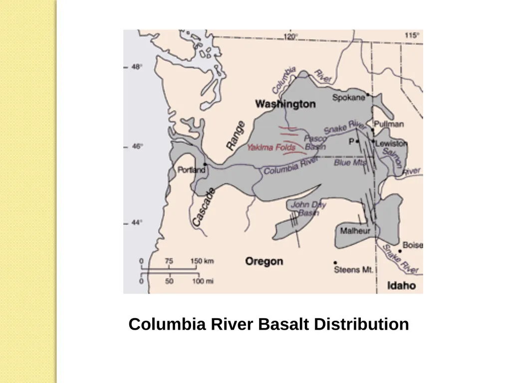
Columbia River Basalt Group The Columbia River Basalt Group lies across parts of the Western United States. It is found in the U.S. states of Washington, Oregon, Idaho, Nevada, and California.
It is one of the largest flood basalts ever to appear on the Earth's surface covering the area of about 163,700 km2
Age of the rocks is late Miocene and early Pliocene.
The Columbia River Basalt Group flows exhibit essentially uniform chemical properties<br>
07
Columbia River Basalt Distribution<br>
08
Central Atlantic Magmatic Province The Central Atlantic magmatic province (CAMP) is a large magma flow formed during the Mesozoic Era, near the end of the Triassic and the beginning of the Jurassic.
It constituting a single major flood basalt province.
The province is extending from central Brazil to western Africa for 5000 km length.
The CAMP is the greatest area known, roughly 11 million km², of any continental.
Nearly all CAMP rocks are tholeiitic in composition,<br>
09
Ontong Java Plateau The Ontong Java Plateau is a huge oceanic plateau located in the Pacific Ocean, lying north of the Solomon Islands.
The plateau covers an area of approximately 2,000,000 km2 and reaches a thickness of up to 30 km.
The plateau is of volcanic origin, composed mostly of flood basalts.
The Ontong Java Plateau was formed 125–120 million years ago<br>
10
Pliocene province of Otago (New Zealand) The Pliocene province of Otago (New Zealand), occupies 2000 square miles area.
It mainly consist of basic volcanic rocks (Alkaline rocks).
The age of the rocks of the province is Late Tertiary<br>
11
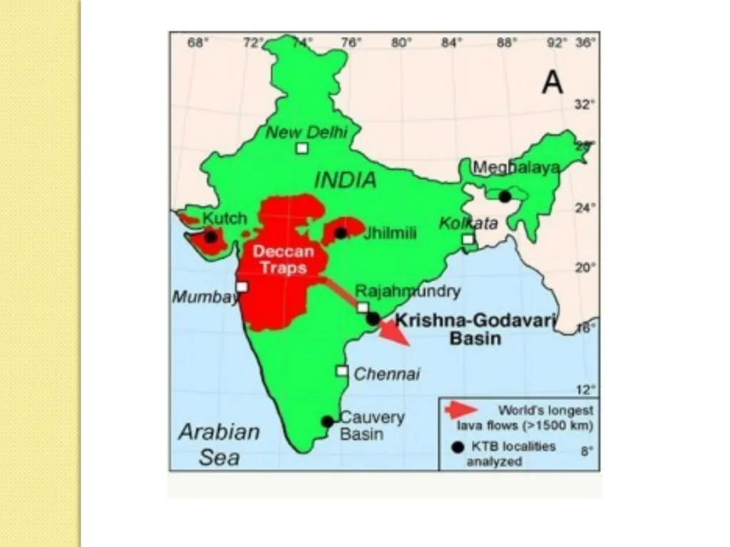
Deccan Traps The Deccan Traps are a large igneous province located on the Deccan Plateau of west-central India.
It is one of the largest volcanic features on Earth, cover an area of 500,000 km2.
The Deccan Traps formed between 60 and 68 million years ago at the end of the Cretaceous period.
Within the Deccan Traps at least 95% of the lavas are tholeiitic basalts.<br>
12
Malani Silicic Province The Malani magmatism represents the largest Precambrian silicic volcanic province on the earth.
This largest outcrop of India constitutes more than 50, 000 km2 area in western India.
The Malani activity took place between 750-770 Ma post-dating the Erinpura granite and ended prior to Marwar Supergroup sedimentation in the northwestern India.
The Malani province is dominated by the silicic volcanics (rhyolites, rhyodacites, trachytes, dacites), popularly known as “Malani Rhyolites”<br>
13
Rajmahal Traps The Rajamal Traps is a volcanic igneous province in Eastern India, covering the parts of Jharkhand, West Bengal and Meghalaya.
Rajmahal hills of Jharkhand is the type area of this province.
This volcanic rocks are formed in the early Cretaceous age.
The Original lava flow covered an area of nearly 4,100 km2 . Below the Bengal basin it is stretched in 200,000 km2
The Rajmahal volcanics are predominantly tholeiitic basalt, quratz tholeiite, olivine tholeiite and alkali basalt.<br>