Physical Features of Pakistan Satellite view of
1 / 1

Physical Features of Pakistan Satellite view of

Author : stefany-barnette | Published Date : 2025-05-10

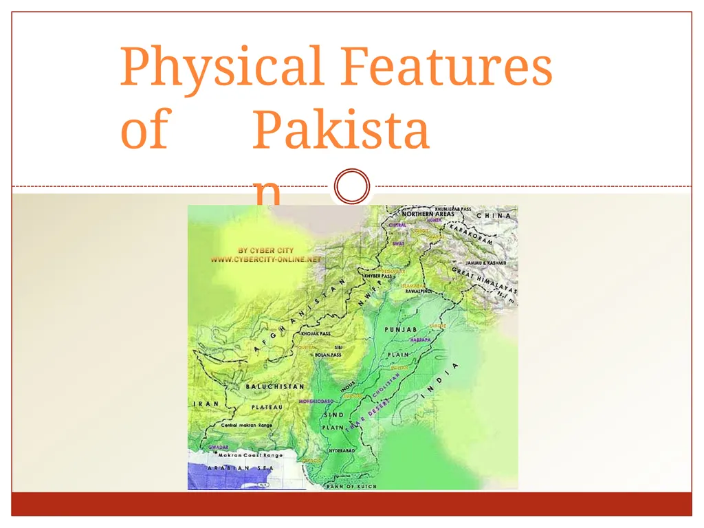
Description: Physical Features of Pakistan Satellite view of South Asia Political Map of Pakistan Neighbors of Pakistan Coordinates Latitude 24 N 37 N Longitude 61 E 755 E Total Area 796096 sq km Altitude Highest point K2 8611m

Presentation Embed Code

Download Presentation

Download Presentation The PPT/PDF document "Physical Features of Pakistan Satellite view of" is the property of its rightful owner. Permission is granted to download and print the materials on this website for personal, non-commercial use only, and to display it on your personal computer provided you do not modify the materials and that you retain all copyright notices contained in the materials. By downloading content from our website, you accept the terms of this agreement.

Transcript:Physical Features of Pakistan Satellite view of:
Physical Features of Pakistan Satellite view of South Asia Political Map of Pakistan Neighbors of Pakistan Coordinates: Latitude: 24° N - 37 °N Longitude: 61 °E - 75.5 ° E Total Area: 796,096 sq km Altitude: Highest point: K-2 (8611m) Deepest point: Dasu patan (6500m) Lowest point: Sea level 0 (feet) Immediate Neighbor Countries Countries Direction Length of border (Km) China North 592 India East 1600 Arabian Sea South 1000 Iran South West 850 Afghanistan West 2250 Physical Map of Pakistan Physical Division of Pakistan Generally We can classify the Pakistan into Four Major Physical provinces which are: Mountains Plains Plateaus Deserts Mountains There are three distinct Mountain ranges Northern Mountains Karakoram Ranges Himalaya Ranges Greater Himalayas Lesser Himalayas Siwaliks North Western Mountains Hindukush Western Mountains Safed Koh Ranges Waziristan Hills Suleman and Kirthar Range Northern Mountains Sub Himalayas Height: 600-1200 meter Great Himalayas Height: more than 4600 meter Lesser Himalayas Height: 1800-4600 meter Himalayas: Northern Mountains Karakorum: Average height is about 6100 meter Goodwin Austin (K-2) 2nd highest peak North Western Mountains Hindu Kush Mountains: Originates from Pamir plateau. highest peaks are Noshaq (7369 m) and Tirch mir (7690 m) lies in the west of Himalaya and karakorum Western Highlands Western highland comprises of the following three mountain ranges. The koh-e-sofaid ranges: Average height is about 3600 m Highest peak is Sikaram (4700 m) Located in East-West Direction Kurram and Kohat valley lies in this range. Western Highlands Waziristan hills: Located between Gomal and Kurram river. Its Height ranges from 1500 - 3000 meter. These range forms the border between Afghanistan and Pakistan Famous Khyber pass lies in this Range. Western Highlands The Suleman and Kirthar Ranges: 1. 2. 3. 4. 5. 6. Starts from South of Gomal River Lies between the Baluchistan plateau and the Indus river. Average height is about 600 m. Takht-e-Suleman is the highest point (3487 m) In south The Suleman joins the kirthar range. And Kirthar merges into the kohistan area of Sindh. The Suleman and Kirthar Ranges: Here We can see the Releif of Suleman and Kirthar range The Indus Plains The Indus Plains The Whole Indus plain comprises the 20% of the Pakistan. We can divide it into three parts; Upper Indus Plain Lower Indus Plain Deltaic Plain The Indus Plains The Upper Indus Plains: Extends from Attock to Mithan kot. Jhelum, Chenab, Ravi and Sutlej are the Eastern tributaries of river

Download Document

Here is the link to download the presentation.
"Physical Features of Pakistan Satellite view of"The content belongs to its owner. You may download and print it for personal use, without modification, and keep all copyright notices. By downloading, you agree to these terms.

Related Presentations

IPv6: The Current Scenario in Pakistan Folk costumes of Peshawar Pakistan Pakistan’s Geopolitical Context - External Threats and In Water and Political Economy of Food  in Pakistan within a c Country Advice Pakistan Pakistan Pakistan's Foreign Policy Application of Satellite Remote Sensing: Brand Name Dapoxetine Pakistan Use of Satellite Data to Improve the Physical Atmosphere Application of Satellite Remote Sensing: August 1947  Pakistan Created with two “wings”  East and West Pakistan Online Bed sheets in Pakistan