South Carolina DOT Training Workshop Geophysics Field Testing Methods, Data Reduction, and Interpretation of Results Robert C. Bachus and Glenn J. Rix June 5 26, 2020 Workshop Topics Overview of Geophysical Methods General Background and
"South Carolina DOT Training Workshop Geophysics" is the property of its rightful owner. Permission is granted to
download and print the materials on this website for personal, non-commercial use only, and to display it
on your personal computer provided you do not modify the materials and that you retain all copyright
notices contained in the materials. By downloading content from our website, you accept the terms of this
agreement.
Presentation Transcript
01
South Carolina DOT Training Workshop Geophysics Field Testing Methods, Data Reduction, and Interpretation of Results Robert C. Bachus and Glenn J. Rix
June 5 – 26, 2020<br>
02
Workshop Topics Overview of Geophysical Methods
General Background and Wave Mechanics
Downhole Testing Methods
Crosshole Testing Methods
Suspension Logging Methods
Surface Wave Methods
Spectral Analysis of Surface Waves (SASW)
Multi-channel Analysis of Surface Waves (MASW)
Microtremor Analysis Method (MAM)
Seismic Refraction
Seismic Reflection<br>
03
Workshop Schedule June 5: 9:00 – 11:30 am
June 12: 8:00 am – 12:00 pm
June 16: 8:00 am – 12:00 pm
June 22: 8:00 am – 12:00 pm
June 26: 8:00 am – 12:00 pm<br>
04
Overview of Geophysical Methods<br>
05
Basic Principles Geophysical investigations are used to estimate the physical properties of the subsurface by measuring, analyzing, and interpreting seismic, electrical, electromagnetic, gravitational, and magnetic fields measured at the ground surface or within boreholes.<br>
06
Strengths Because surface geophysical methods are noninvasive, they provide the ability to cover a large area in a time- and cost-effective manner to gain an understanding of the overall subsurface conditions. This characteristic enables optimizing the locations of borings and soundings during subsequent phases of a subsurface exploration program or interpolating between existing borings and soundings.
Geophysical methods are robust in the sense that they are based on fundamental physical principles with relatively little reliance on empiricism. In many cases, the methods used for geotechnical applications leverage the extensive experience gained with similar methods developed for resource (e.g., oil, gas) exploration.
Surface geophysical methods are also useful for sites where borings and soundings are difficult or impractical, such as gravel deposits or contaminated soils. The equipment used for many geophysical tests is highly portable, which may allow testing at sites that are not easily accessible (e.g., a heavily wooded area) using conventional drilling equipment.<br>
07
Limitations Geophysical methods are more likely to yield good results when (i) there is a large contrast in seismic, electrical, electromagnetic, gravitational, or magnetic properties between lithologic units or between an anomaly and the surrounding soils and rocks, and (ii) the subsurface features of interest are of sufficient size relative to their depth that they are within the limits of detection for a particular geophysical method.
The interpreted subsurface conditions may not be unique for many geophysical methods; there may be multiple, physically plausible interpretations for the stratigraphy or location and size of anomalies that all yield the same measured geophysical response. For example, a structural low in bedrock topography; a small, air-filled void in the bedrock; or a larger, water-filled void in the bedrock may all produce the same magnitude of gravity anomaly.
Sites that have a stiff, surficial layer overlying a weaker layer or an electrically resistive layer over a conductive layer pose a challenge for many surface geophysical tests. For example, many seismic methods do not work well on concrete pavements because of the large stiffness of the pavement compared to the base and subgrade materials.<br>
08
Implementation Because geophysical methods are less familiar to many geotechnical engineers than conventional site investigation methods (e.g., SPT, CPT), it is essential that geophysical investigations be conducted by personnel who are trained and experienced in near-surface geophysics.
The results of geophysical investigations should always be complemented by direct observation of subsurface conditions by means of borings, soundings, test pits, trenches, outcrops, and other geological information. This ground truth information will help ensure that interpreted subsurface conditions derived from geophysical methods are as accurate as possible.
The combined use of a geophysical investigation with direct observation is a robust approach to developing an accurate ground model for a project.<br>
09
Implementation Planning the investigation
Executing the investigation
Interpreting the results of the investigation
Reporting and presenting results of the investigation<br>
10
Implementation Planning the investigation
Developing a geophysical testing plan
Selecting the number and locations for in situ tests, drilling, and sampling
Determining the minimum depth of investigation at each location
Determining the required types of samples and the sampling frequency
Developing an in situ and laboratory testing plan
Developing a plan for evaluating groundwater conditions
Executing the investigation
Interpreting the results of the investigation
Reporting and presenting results of the investigation<br>
11
Planning a Geophysical Investigation What are the physical properties of interest?
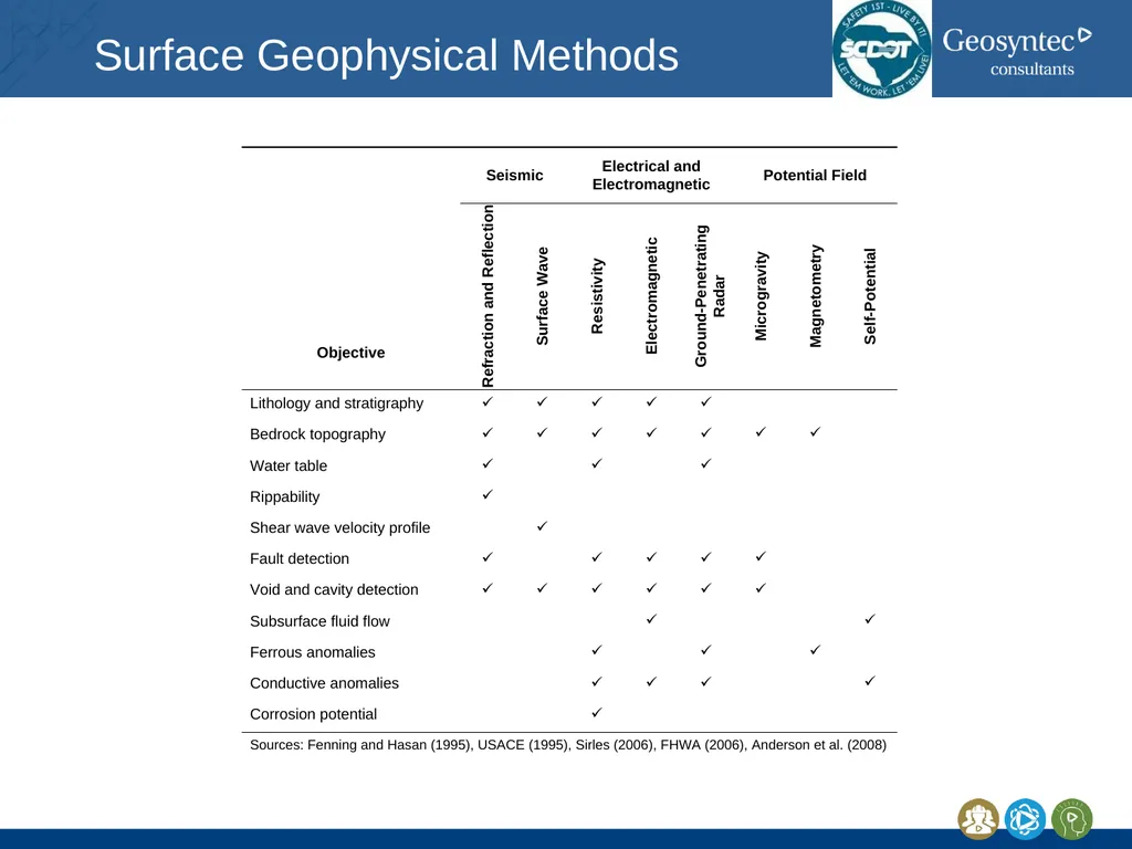
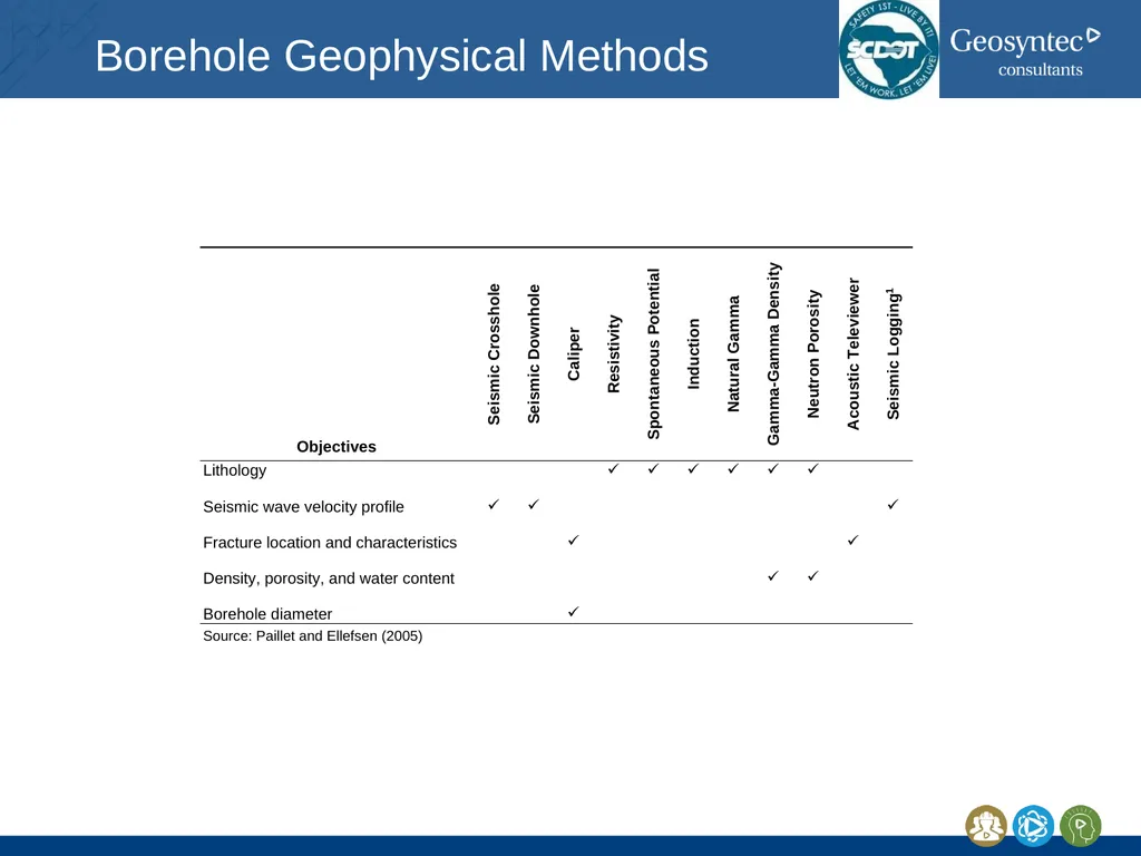
Which methods respond to the physical properties of interest?
Which methods can provide the required levels of detection and resolution for the subsurface features of interest?
Which methods can perform well given conditions at the project site?
Which methods provide complementary information to help improve interpretations based on the observed data?
What direct observations (e.g., borings or soundings) should be performed to constrain the interpretation of geophysical data?
Which methods are most cost effective, and is the overall geophysical investigation cost effective?<br>
12
Detection<br>
13
Resolution Resolution: the minimum separation distance required to distinguish adjacent targets for a given geophysical method
Depends on contrast
Often depends on depth<br>