
STORM WATER Subject: Infrastructure and Transport

Description: STORM WATER Subject: Infrastructure and Transport Planning Topic: Storm Water Presented by: Aditi Arora In Delhi area, there are many factors which influence the rainfall, such as geographic position, Monsoon, topographic, and other factor,
Related Topics
Download Presentation
"STORM WATER Subject: Infrastructure and Transport" is the property of its rightful owner. Permission is granted to download and print the materials on this website for personal, non-commercial use only, and to display it on your personal computer provided you do not modify the materials and that you retain all copyright notices contained in the materials. By downloading content from our website, you accept the terms of this agreement.
Presentation Transcript
slide1. STORM WATER Subject: Infrastructure and Transport Planning
Topic: Storm Water
Presented by: Aditi Arora<br>
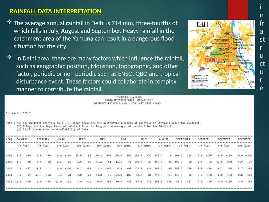
slide2. In Delhi area, there are many factors which influence the rainfall, such as geographic position, Monsoon, topographic, and other factor, periodic or non periodic such as ENSO, QBO and tropical disturbance event. These factors could collaborate in complex manner to contribute the rainfall. The average annual rainfall in Delhi is 714 mm, three-fourths of which falls in July, August and September. Heavy rainfall in the catchment area of the Yamuna can result in a dangerous flood situation for the city. RAINFALL DATA INTERPRETATION infrastructure<br>
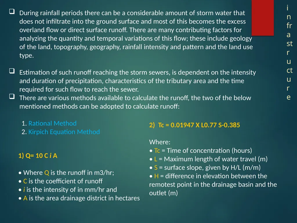
slide3. During rainfall periods there can be a considerable amount of storm water that does not infiltrate into the ground surface and most of this becomes the excess overland flow or direct surface runoff. There are many contributing factors for analyzing the quantity and temporal variations of this flow; these include geology of the land, topography, geography, rainfall intensity and pattern and the land use type.
Estimation of such runoff reaching the storm sewers, is dependent on the intensity and duration of precipitation, characteristics of the tributary area and the time required for such flow to reach the sewer.
There are various methods available to calculate the runoff, the two of the below mentioned methods can be adopted to calculate runoff:
1. Rational Method
2. Kirpich Equation Method 1) Q= 10 C i A
• Where Q is the runoff in m3/hr;
• C is the coefficient of runoff
• i is the intensity of in mm/hr and
• A is the area drainage district in hectares 2) Tc = 0.01947 X L0.77 S-0.385
Where:
• Tc = Time of concentration (hours)
• L = Maximum length of water travel (m)
• S = surface slope, given by H/L (m/m)
• H = difference in elevation between the remotest point in the drainage basin and the outlet (m) infrastructure<br>
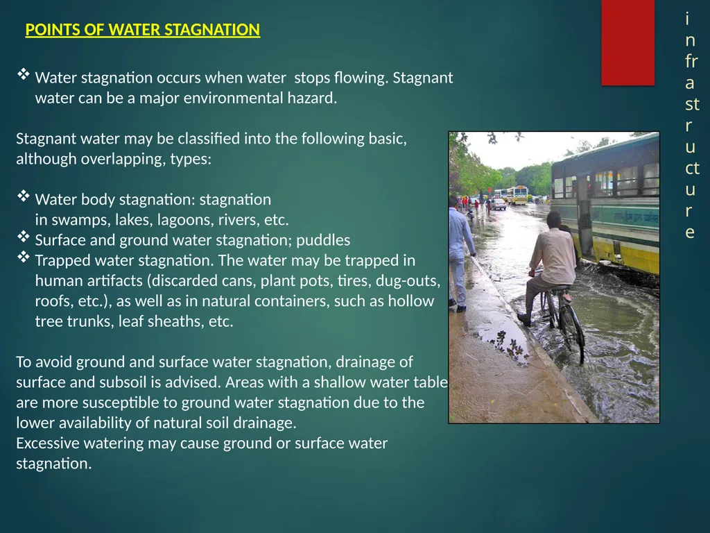
slide4. Water stagnation occurs when water stops flowing. Stagnant water can be a major environmental hazard.
Stagnant water may be classified into the following basic, although overlapping, types:
Water body stagnation: stagnation in swamps, lakes, lagoons, rivers, etc.
Surface and ground water stagnation; puddles
Trapped water stagnation. The water may be trapped in human artifacts (discarded cans, plant pots, tires, dug-outs, roofs, etc.), as well as in natural containers, such as hollow tree trunks, leaf sheaths, etc.
To avoid ground and surface water stagnation, drainage of surface and subsoil is advised. Areas with a shallow water table are more susceptible to ground water stagnation due to the lower availability of natural soil drainage.
Excessive watering may cause ground or surface water stagnation. POINTS OF WATER STAGNATION infrastructure<br>
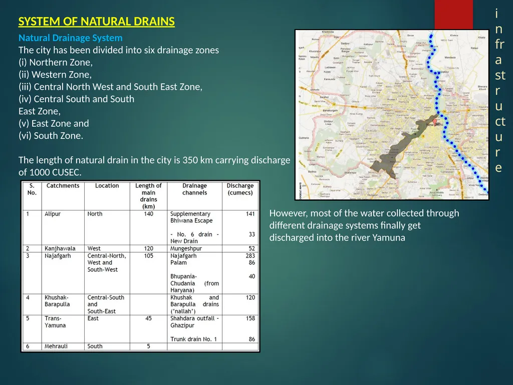
slide5. Natural Drainage System
The city has been divided into six drainage zones
(i) Northern Zone,
(ii) Western Zone,
(iii) Central North West and South East Zone,
(iv) Central South and South
East Zone,
(v) East Zone and
(vi) South Zone.
The length of natural drain in the city is 350 km carrying discharge of 1000 CUSEC. However, most of the water collected through different drainage systems finally get discharged into the river Yamuna SYSTEM OF NATURAL DRAINS infrastructure<br>
Topic: Storm Water
Presented by: Aditi Arora<br>
slide2. In Delhi area, there are many factors which influence the rainfall, such as geographic position, Monsoon, topographic, and other factor, periodic or non periodic such as ENSO, QBO and tropical disturbance event. These factors could collaborate in complex manner to contribute the rainfall. The average annual rainfall in Delhi is 714 mm, three-fourths of which falls in July, August and September. Heavy rainfall in the catchment area of the Yamuna can result in a dangerous flood situation for the city. RAINFALL DATA INTERPRETATION infrastructure<br>
slide3. During rainfall periods there can be a considerable amount of storm water that does not infiltrate into the ground surface and most of this becomes the excess overland flow or direct surface runoff. There are many contributing factors for analyzing the quantity and temporal variations of this flow; these include geology of the land, topography, geography, rainfall intensity and pattern and the land use type.
Estimation of such runoff reaching the storm sewers, is dependent on the intensity and duration of precipitation, characteristics of the tributary area and the time required for such flow to reach the sewer.
There are various methods available to calculate the runoff, the two of the below mentioned methods can be adopted to calculate runoff:
1. Rational Method
2. Kirpich Equation Method 1) Q= 10 C i A
• Where Q is the runoff in m3/hr;
• C is the coefficient of runoff
• i is the intensity of in mm/hr and
• A is the area drainage district in hectares 2) Tc = 0.01947 X L0.77 S-0.385
Where:
• Tc = Time of concentration (hours)
• L = Maximum length of water travel (m)
• S = surface slope, given by H/L (m/m)
• H = difference in elevation between the remotest point in the drainage basin and the outlet (m) infrastructure<br>
slide4. Water stagnation occurs when water stops flowing. Stagnant water can be a major environmental hazard.
Stagnant water may be classified into the following basic, although overlapping, types:
Water body stagnation: stagnation in swamps, lakes, lagoons, rivers, etc.
Surface and ground water stagnation; puddles
Trapped water stagnation. The water may be trapped in human artifacts (discarded cans, plant pots, tires, dug-outs, roofs, etc.), as well as in natural containers, such as hollow tree trunks, leaf sheaths, etc.
To avoid ground and surface water stagnation, drainage of surface and subsoil is advised. Areas with a shallow water table are more susceptible to ground water stagnation due to the lower availability of natural soil drainage.
Excessive watering may cause ground or surface water stagnation. POINTS OF WATER STAGNATION infrastructure<br>
slide5. Natural Drainage System
The city has been divided into six drainage zones
(i) Northern Zone,
(ii) Western Zone,
(iii) Central North West and South East Zone,
(iv) Central South and South
East Zone,
(v) East Zone and
(vi) South Zone.
The length of natural drain in the city is 350 km carrying discharge of 1000 CUSEC. However, most of the water collected through different drainage systems finally get discharged into the river Yamuna SYSTEM OF NATURAL DRAINS infrastructure<br>