
Study of Tectonic Plates Interactions Using IMS
Description: Study of Tectonic Plates Interactions Using IMS Stations: An Example of Inter-NDC Cooperation and Regional Empowerment Introduction Slide Title goes here Font: Arial BoldSize: 16 P5.2-832 U.O. Madu1; D.R. Seif2 and J.K. Mulwa3 This study
Related Topics
Download Presentation
"Study of Tectonic Plates Interactions Using IMS" is the property of its rightful owner. Permission is granted to download and print the materials on this website for personal, non-commercial use only, and to display it on your personal computer provided you do not modify the materials and that you retain all copyright notices contained in the materials. By downloading content from our website, you accept the terms of this agreement.
Presentation Transcript
slide1. Study of Tectonic Plates Interactions Using IMS Stations: An Example of Inter-NDC Cooperation and Regional Empowerment Introduction Slide Title goes here [Font: Arial Bold/Size: 16] P5.2-832 U.O. Madu1; D.R. Seif2 and J.K. Mulwa3 This study provides insights to cooperation between NDCs as it relates to data analysis and the use of the results from such analysis to provide information to policymakers. Three NDCs from Nigeria, Tanzania and Kenya collaborated in the study. It gives an overview how IMS data can be deployed for scientific purpose using the earthquake that occurred on 7 January 2025, in Dingri County within the southern part of the Tibetan Plateau. The epicentre of the earthquakes lies close to the Indian-Eurasian plate boundary. The earthquakes were caused by normal faulting at a shallow depth of 10km with Ms=7.0 and mb=5.8. This study therefore shows the importance of the IMS network of stations towards capacity development and regional cooperation. 1Nigeria Atomic Energy Commission, Abuja, Nigeria
2Tanzania Atomic Energy Commission, Dodoma, Tanzania
3University of Nairobi, Department of Earth and Climate Sciences, Nairobi, Kenya DISCLAIMER: This presentation has been generated for illustration purposes only.<br>
slide2. Introduction Study of Tectonic Plates Interactions Using IMS Stations: An Example of Inter-NDC Cooperation and Regional Empowerment One of the functions of an NDC is to advice policymakers from the results of analysis of verification data from the IMS. Analyzing data and proper interpretation of the analyzed data therefore are important for the operation of NDCs. The IMS data analyse using the IDC products has found use in both scientific and civil applications. An example of such an application is the earthquake that occurred on 7 January 2025, in Dingri County within the southern part of the Tibetan Plateau lying in the Himalayan block of the Gangdise–Himalayas orogenic belt. The epicenter is situated near the intersection of several major faults, including the Tian Shan Fault and the Tarim Basin Fault (Figure 1)
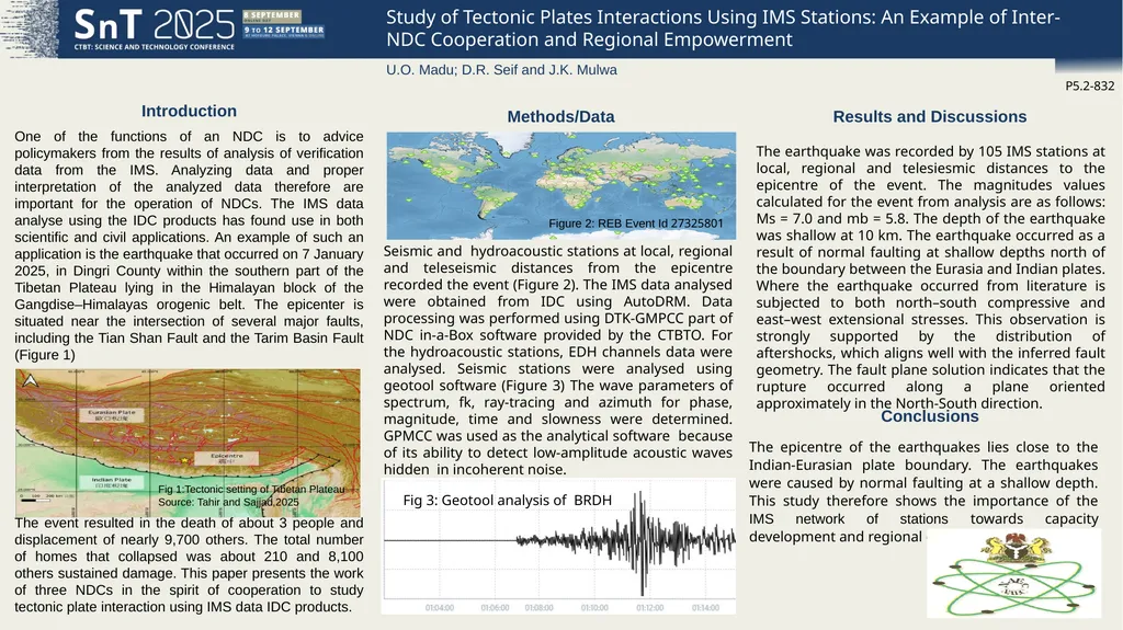
The event resulted in the death of about 3 people and displacement of nearly 9,700 others. The total number of homes that collapsed was about 210 and 8,100 others sustained damage. This paper presents the work of three NDCs in the spirit of cooperation to study tectonic plate interaction using IMS data IDC products. Seismic and hydroacoustic stations at local, regional and teleseismic distances from the epicentre recorded the event (Figure 2). The IMS data analysed were obtained from IDC using AutoDRM. Data processing was performed using DTK-GMPCC part of NDC in-a-Box software provided by the CTBTO. For the hydroacoustic stations, EDH channels data were analysed. Seismic stations were analysed using geotool software (Figure 3) The wave parameters of spectrum, fk, ray-tracing and azimuth for phase, magnitude, time and slowness were determined. GPMCC was used as the analytical software because of its ability to detect low-amplitude acoustic waves hidden in incoherent noise. The earthquake was recorded by 105 IMS stations at local, regional and telesiesmic distances to the epicentre of the event. The magnitudes values calculated for the event from analysis are as follows: Ms = 7.0 and mb = 5.8. The depth of the earthquake was shallow at 10 km. The earthquake occurred as a result of normal faulting at shallow depths north of the boundary between the Eurasia and Indian plates. Where the earthquake occurred from literature is subjected to both north–south compressive and east–west extensional stresses. This observation is strongly supported by the distribution of aftershocks, which aligns well with the inferred fault geometry. The fault plane solution indicates that the rupture occurred along a plane oriented approximately in the North-South direction. P5.2-832 U.O. Madu; D.R. Seif and J.K. Mulwa Methods/Data Results and Discussions Conclusions The epicentre of the earthquakes lies close to the Indian-Eurasian plate boundary. The earthquakes were caused by normal faulting at a shallow depth. This study therefore shows the importance of the IMS network of stations towards capacity development and regional cooperation. Fig 1:Tectonic setting of Tibetan Plateau
Source: Tahir and Sajjad,2025 Figure 2: REB Event Id 27325801 Fig 3: Geotool analysis of BRDH<br>
2Tanzania Atomic Energy Commission, Dodoma, Tanzania
3University of Nairobi, Department of Earth and Climate Sciences, Nairobi, Kenya DISCLAIMER: This presentation has been generated for illustration purposes only.<br>
slide2. Introduction Study of Tectonic Plates Interactions Using IMS Stations: An Example of Inter-NDC Cooperation and Regional Empowerment One of the functions of an NDC is to advice policymakers from the results of analysis of verification data from the IMS. Analyzing data and proper interpretation of the analyzed data therefore are important for the operation of NDCs. The IMS data analyse using the IDC products has found use in both scientific and civil applications. An example of such an application is the earthquake that occurred on 7 January 2025, in Dingri County within the southern part of the Tibetan Plateau lying in the Himalayan block of the Gangdise–Himalayas orogenic belt. The epicenter is situated near the intersection of several major faults, including the Tian Shan Fault and the Tarim Basin Fault (Figure 1)
The event resulted in the death of about 3 people and displacement of nearly 9,700 others. The total number of homes that collapsed was about 210 and 8,100 others sustained damage. This paper presents the work of three NDCs in the spirit of cooperation to study tectonic plate interaction using IMS data IDC products. Seismic and hydroacoustic stations at local, regional and teleseismic distances from the epicentre recorded the event (Figure 2). The IMS data analysed were obtained from IDC using AutoDRM. Data processing was performed using DTK-GMPCC part of NDC in-a-Box software provided by the CTBTO. For the hydroacoustic stations, EDH channels data were analysed. Seismic stations were analysed using geotool software (Figure 3) The wave parameters of spectrum, fk, ray-tracing and azimuth for phase, magnitude, time and slowness were determined. GPMCC was used as the analytical software because of its ability to detect low-amplitude acoustic waves hidden in incoherent noise. The earthquake was recorded by 105 IMS stations at local, regional and telesiesmic distances to the epicentre of the event. The magnitudes values calculated for the event from analysis are as follows: Ms = 7.0 and mb = 5.8. The depth of the earthquake was shallow at 10 km. The earthquake occurred as a result of normal faulting at shallow depths north of the boundary between the Eurasia and Indian plates. Where the earthquake occurred from literature is subjected to both north–south compressive and east–west extensional stresses. This observation is strongly supported by the distribution of aftershocks, which aligns well with the inferred fault geometry. The fault plane solution indicates that the rupture occurred along a plane oriented approximately in the North-South direction. P5.2-832 U.O. Madu; D.R. Seif and J.K. Mulwa Methods/Data Results and Discussions Conclusions The epicentre of the earthquakes lies close to the Indian-Eurasian plate boundary. The earthquakes were caused by normal faulting at a shallow depth. This study therefore shows the importance of the IMS network of stations towards capacity development and regional cooperation. Fig 1:Tectonic setting of Tibetan Plateau
Source: Tahir and Sajjad,2025 Figure 2: REB Event Id 27325801 Fig 3: Geotool analysis of BRDH<br>