
TECHNICAL REPORT Seismic Imaging within the UKCS
KB
Published · 7 slides · 0 views
1 / 1
Description
TECHNICAL REPORT Seismic Imaging within the UKCS Energy Transition Environment. Acronyms Glossary 10 October 2023 Acronyms Glossary 2 Numerical 2D - Seismic survey conducted with a sparse series of lines across a target. 2.5D -
Related Topics
Share
Embed code
Download this presentation From Below
"TECHNICAL REPORT Seismic Imaging within the UKCS" is the property of its rightful owner. Permission is granted to download and print the materials on this website for personal, non-commercial use only, and to display it on your personal computer provided you do not modify the materials and that you retain all copyright notices contained in the materials. By downloading content from our website, you accept the terms of this agreement.
Presentation Transcript
01
TECHNICAL REPORT Seismic Imaging within the UKCS Energy Transition Environment.
Acronyms & Glossary 10 October 2023<br>
Acronyms & Glossary 10 October 2023<br>
02
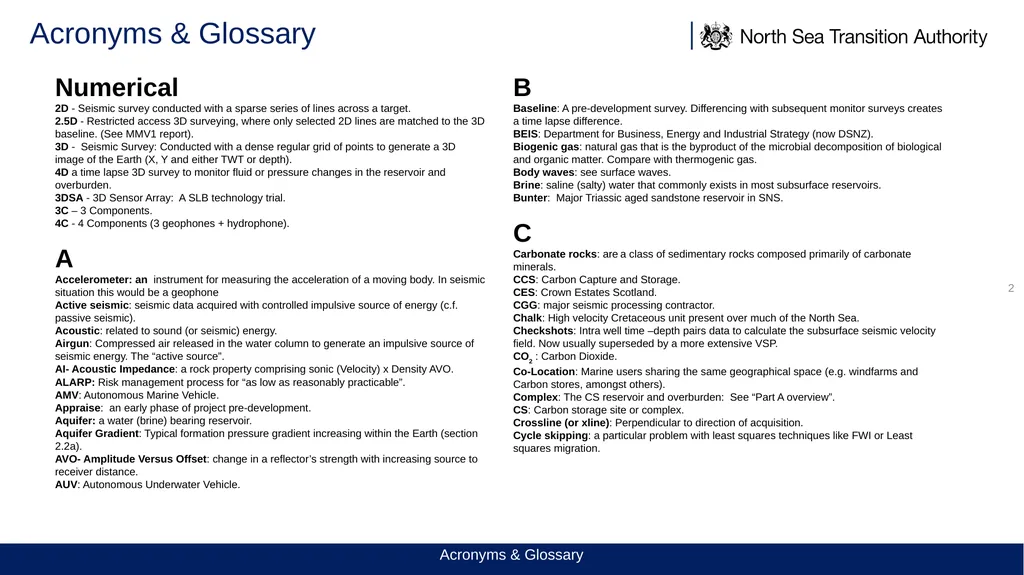
Acronyms & Glossary 2 Numerical
2D - Seismic survey conducted with a sparse series of lines across a target.
2.5D - Restricted access 3D surveying, where only selected 2D lines are matched to the 3D baseline. (See MMV1 report).
3D - Seismic Survey: Conducted with a dense regular grid of points to generate a 3D image of the Earth (X, Y and either TWT or depth).
4D a time lapse 3D survey to monitor fluid or pressure changes in the reservoir and overburden.
3DSA - 3D Sensor Array: A SLB technology trial.
3C – 3 Components.
4C - 4 Components (3 geophones + hydrophone).
A
Accelerometer: an instrument for measuring the acceleration of a moving body. In seismic situation this would be a geophone
Active seismic: seismic data acquired with controlled impulsive source of energy (c.f. passive seismic).
Acoustic: related to sound (or seismic) energy.
Airgun: Compressed air released in the water column to generate an impulsive source of seismic energy. The “active source”.
AI- Acoustic Impedance: a rock property comprising sonic (Velocity) x Density AVO.
ALARP: Risk management process for “as low as reasonably practicable”.
AMV: Autonomous Marine Vehicle.
Appraise: an early phase of project pre-development.
Aquifer: a water (brine) bearing reservoir.
Aquifer Gradient: Typical formation pressure gradient increasing within the Earth (section 2.2a).
AVO- Amplitude Versus Offset: change in a reflector’s strength with increasing source to receiver distance.
AUV: Autonomous Underwater Vehicle. B
Baseline: A pre-development survey. Differencing with subsequent monitor surveys creates a time lapse difference.
BEIS: Department for Business, Energy and Industrial Strategy (now DSNZ).
Biogenic gas: natural gas that is the byproduct of the microbial decomposition of biological and organic matter. Compare with thermogenic gas.
Body waves: see surface waves.
Brine: saline (salty) water that commonly exists in most subsurface reservoirs.
Bunter: Major Triassic aged sandstone reservoir in SNS.
C
Carbonate rocks: are a class of sedimentary rocks composed primarily of carbonate minerals.
CCS: Carbon Capture and Storage.
CES: Crown Estates Scotland.
CGG: major seismic processing contractor.
Chalk: High velocity Cretaceous unit present over much of the North Sea.
Checkshots: Intra well time –depth pairs data to calculate the subsurface seismic velocity field. Now usually superseded by a more extensive VSP.
CO2 : Carbon Dioxide.
Co-Location: Marine users sharing the same geographical space (e.g. windfarms and Carbon stores, amongst others).
Complex: The CS reservoir and overburden: See “Part A overview”.
CS: Carbon storage site or complex.
Crossline (or xline): Perpendicular to direction of acquisition.
Cycle skipping: a particular problem with least squares techniques like FWI or Least squares migration. Acronyms & Glossary<br>
2D - Seismic survey conducted with a sparse series of lines across a target.
2.5D - Restricted access 3D surveying, where only selected 2D lines are matched to the 3D baseline. (See MMV1 report).
3D - Seismic Survey: Conducted with a dense regular grid of points to generate a 3D image of the Earth (X, Y and either TWT or depth).
4D a time lapse 3D survey to monitor fluid or pressure changes in the reservoir and overburden.
3DSA - 3D Sensor Array: A SLB technology trial.
3C – 3 Components.
4C - 4 Components (3 geophones + hydrophone).
A
Accelerometer: an instrument for measuring the acceleration of a moving body. In seismic situation this would be a geophone
Active seismic: seismic data acquired with controlled impulsive source of energy (c.f. passive seismic).
Acoustic: related to sound (or seismic) energy.
Airgun: Compressed air released in the water column to generate an impulsive source of seismic energy. The “active source”.
AI- Acoustic Impedance: a rock property comprising sonic (Velocity) x Density AVO.
ALARP: Risk management process for “as low as reasonably practicable”.
AMV: Autonomous Marine Vehicle.
Appraise: an early phase of project pre-development.
Aquifer: a water (brine) bearing reservoir.
Aquifer Gradient: Typical formation pressure gradient increasing within the Earth (section 2.2a).
AVO- Amplitude Versus Offset: change in a reflector’s strength with increasing source to receiver distance.
AUV: Autonomous Underwater Vehicle. B
Baseline: A pre-development survey. Differencing with subsequent monitor surveys creates a time lapse difference.
BEIS: Department for Business, Energy and Industrial Strategy (now DSNZ).
Biogenic gas: natural gas that is the byproduct of the microbial decomposition of biological and organic matter. Compare with thermogenic gas.
Body waves: see surface waves.
Brine: saline (salty) water that commonly exists in most subsurface reservoirs.
Bunter: Major Triassic aged sandstone reservoir in SNS.
C
Carbonate rocks: are a class of sedimentary rocks composed primarily of carbonate minerals.
CCS: Carbon Capture and Storage.
CES: Crown Estates Scotland.
CGG: major seismic processing contractor.
Chalk: High velocity Cretaceous unit present over much of the North Sea.
Checkshots: Intra well time –depth pairs data to calculate the subsurface seismic velocity field. Now usually superseded by a more extensive VSP.
CO2 : Carbon Dioxide.
Co-Location: Marine users sharing the same geographical space (e.g. windfarms and Carbon stores, amongst others).
Complex: The CS reservoir and overburden: See “Part A overview”.
CS: Carbon storage site or complex.
Crossline (or xline): Perpendicular to direction of acquisition.
Cycle skipping: a particular problem with least squares techniques like FWI or Least squares migration. Acronyms & Glossary<br>
03
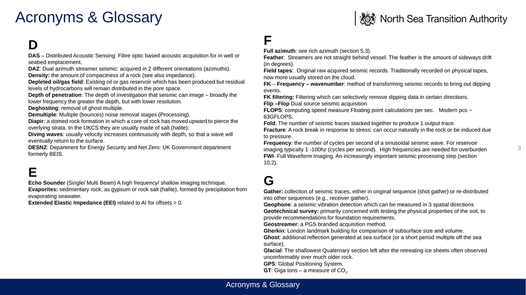
Acronyms & Glossary 3 D
DAS – Distributed Acoustic Sensing: Fibre optic based acoustic acquisition for in well or seabed emplacement.
DAZ: Dual azimuth streamer seismic: acquired in 2 different orientations (azimuths).
Density: the amount of compactness of a rock (see also impedance).
Depleted oil/gas field: Existing oil or gas reservoir which has been produced but residual levels of hydrocarbons will remain distributed in the pore space.
Depth of penetration: The depth of investigation that seismic can image – broadly the lower frequency the greater the depth, but with lower resolution.
Deghosting: removal of ghost multiple.
Demultiple: Multiple (bounces) noise removal stages (Processing).
Diapir: a domed rock formation in which a core of rock has moved upward to pierce the overlying strata. In the UKCS they are usually made of salt (halite).
Diving waves: usually velocity increases continuously with depth, so that a wave will eventually return to the surface.
DESNZ: Department for Energy Security and Net Zero: UK Government department formerly BEIS.
E
Echo Sounder (Single/ Multi Beam) A high frequency/ shallow imaging technique.
Evaporites: sedimentary rock, as gypsum or rock salt (halite), formed by precipitation from evaporating seawater.
Extended Elastic Impedance (EEI) related to AI for offsets > 0. F
Full azimuth: see rich azimuth (section 5.3).
Feather: Streamers are not straight behind vessel. The feather is the amount of sideways drift (in degrees).
Field tapes: Original raw acquired seismic records. Traditionally recorded on physical tapes, now more usually stored on the cloud.
FK – Frequency – wavenumber: method of transforming seismic records to bring out dipping events.
FK filtering: Filtering which can selectively remove dipping data in certain directions.
Flip –Flop Dual source seismic acquisition
FLOPS: computing speed measure Floating point calculations per sec. Modern pcs ~ 63GFLOPS.
Fold: The number of seismic traces stacked together to produce 1 output trace.
Fracture: A rock break in response to stress: can occur naturally in the rock or be induced due to pressure.
Frequency: the number of cycles per second of a sinusoidal seismic wave. For reservoir imaging typically 1 -100hz (cycles per second). High frequencies are needed for overburden
FWI- Full Waveform Imaging. An increasingly important seismic processing step (section 10.2).
G
Gather: collection of seismic traces, either in original sequence (shot gather) or re-distributed into other sequences (e.g., receiver gather).
Geophone: a seismic vibration detection which can be measured in 3 spatial directions
Geotechnical survey: primarily concerned with testing the physical properties of the soil, to provide recommendations for foundation requirements.
Geostreamer: a PGS branded acquisition method.
Gherkin: London landmark building for comparison of subsurface size and volume.
Ghost: additional reflection generated at sea surface (or a short period multiple off the sea surface).
Glacial: The shallowest Quaternary section left after the retreating ice sheets often observed unconformably over much older rock.
GPS: Global Positioning System.
GT: Giga tons – a measure of CO2. Acronyms & Glossary<br>
DAS – Distributed Acoustic Sensing: Fibre optic based acoustic acquisition for in well or seabed emplacement.
DAZ: Dual azimuth streamer seismic: acquired in 2 different orientations (azimuths).
Density: the amount of compactness of a rock (see also impedance).
Depleted oil/gas field: Existing oil or gas reservoir which has been produced but residual levels of hydrocarbons will remain distributed in the pore space.
Depth of penetration: The depth of investigation that seismic can image – broadly the lower frequency the greater the depth, but with lower resolution.
Deghosting: removal of ghost multiple.
Demultiple: Multiple (bounces) noise removal stages (Processing).
Diapir: a domed rock formation in which a core of rock has moved upward to pierce the overlying strata. In the UKCS they are usually made of salt (halite).
Diving waves: usually velocity increases continuously with depth, so that a wave will eventually return to the surface.
DESNZ: Department for Energy Security and Net Zero: UK Government department formerly BEIS.
E
Echo Sounder (Single/ Multi Beam) A high frequency/ shallow imaging technique.
Evaporites: sedimentary rock, as gypsum or rock salt (halite), formed by precipitation from evaporating seawater.
Extended Elastic Impedance (EEI) related to AI for offsets > 0. F
Full azimuth: see rich azimuth (section 5.3).
Feather: Streamers are not straight behind vessel. The feather is the amount of sideways drift (in degrees).
Field tapes: Original raw acquired seismic records. Traditionally recorded on physical tapes, now more usually stored on the cloud.
FK – Frequency – wavenumber: method of transforming seismic records to bring out dipping events.
FK filtering: Filtering which can selectively remove dipping data in certain directions.
Flip –Flop Dual source seismic acquisition
FLOPS: computing speed measure Floating point calculations per sec. Modern pcs ~ 63GFLOPS.
Fold: The number of seismic traces stacked together to produce 1 output trace.
Fracture: A rock break in response to stress: can occur naturally in the rock or be induced due to pressure.
Frequency: the number of cycles per second of a sinusoidal seismic wave. For reservoir imaging typically 1 -100hz (cycles per second). High frequencies are needed for overburden
FWI- Full Waveform Imaging. An increasingly important seismic processing step (section 10.2).
G
Gather: collection of seismic traces, either in original sequence (shot gather) or re-distributed into other sequences (e.g., receiver gather).
Geophone: a seismic vibration detection which can be measured in 3 spatial directions
Geotechnical survey: primarily concerned with testing the physical properties of the soil, to provide recommendations for foundation requirements.
Geostreamer: a PGS branded acquisition method.
Gherkin: London landmark building for comparison of subsurface size and volume.
Ghost: additional reflection generated at sea surface (or a short period multiple off the sea surface).
Glacial: The shallowest Quaternary section left after the retreating ice sheets often observed unconformably over much older rock.
GPS: Global Positioning System.
GT: Giga tons – a measure of CO2. Acronyms & Glossary<br>
04
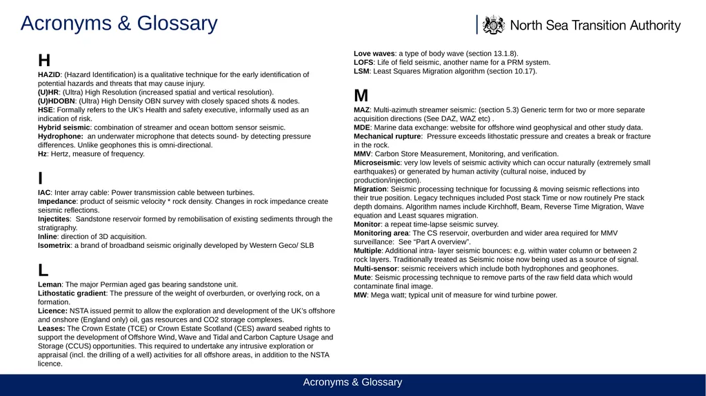
Acronyms & Glossary H
HAZID: (Hazard Identification) is a qualitative technique for the early identification of potential hazards and threats that may cause injury.
(U)HR: (Ultra) High Resolution (increased spatial and vertical resolution).
(U)HDOBN: (Ultra) High Density OBN survey with closely spaced shots & nodes.
HSE: Formally refers to the UK’s Health and safety executive, informally used as an indication of risk.
Hybrid seismic: combination of streamer and ocean bottom sensor seismic.
Hydrophone: an underwater microphone that detects sound- by detecting pressure differences. Unlike geophones this is omni-directional.
Hz: Hertz, measure of frequency.
I
IAC: Inter array cable: Power transmission cable between turbines.
Impedance: product of seismic velocity * rock density. Changes in rock impedance create seismic reflections.
Injectites: Sandstone reservoir formed by remobilisation of existing sediments through the stratigraphy.
Inline: direction of 3D acquisition.
Isometrix: a brand of broadband seismic originally developed by Western Geco/ SLB
L
Leman: The major Permian aged gas bearing sandstone unit.
Lithostatic gradient: The pressure of the weight of overburden, or overlying rock, on a formation.
Licence: NSTA issued permit to allow the exploration and development of the UK’s offshore and onshore (England only) oil, gas resources and CO2 storage complexes.
Leases: The Crown Estate (TCE) or Crown Estate Scotland (CES) award seabed rights to support the development of Offshore Wind, Wave and Tidal and Carbon Capture Usage and Storage (CCUS) opportunities. This required to undertake any intrusive exploration or appraisal (incl. the drilling of a well) activities for all offshore areas, in addition to the NSTA licence. Love waves: a type of body wave (section 13.1.8).
LOFS: Life of field seismic, another name for a PRM system.
LSM: Least Squares Migration algorithm (section 10.17).
M
MAZ: Multi-azimuth streamer seismic: (section 5.3) Generic term for two or more separate acquisition directions (See DAZ, WAZ etc) .
MDE: Marine data exchange: website for offshore wind geophysical and other study data.
Mechanical rupture: Pressure exceeds lithostatic pressure and creates a break or fracture in the rock.
MMV: Carbon Store Measurement, Monitoring, and verification.
Microseismic: very low levels of seismic activity which can occur naturally (extremely small earthquakes) or generated by human activity (cultural noise, induced by production/injection).
Migration: Seismic processing technique for focussing & moving seismic reflections into their true position. Legacy techniques included Post stack Time or now routinely Pre stack depth domains. Algorithm names include Kirchhoff, Beam, Reverse Time Migration, Wave equation and Least squares migration.
Monitor: a repeat time-lapse seismic survey.
Monitoring area: The CS reservoir, overburden and wider area required for MMV surveillance: See “Part A overview”.
Multiple: Additional intra- layer seismic bounces: e.g. within water column or between 2 rock layers. Traditionally treated as Seismic noise now being used as a source of signal.
Multi-sensor: seismic receivers which include both hydrophones and geophones.
Mute: Seismic processing technique to remove parts of the raw field data which would contaminate final image.
MW: Mega watt; typical unit of measure for wind turbine power. Acronyms & Glossary<br>
HAZID: (Hazard Identification) is a qualitative technique for the early identification of potential hazards and threats that may cause injury.
(U)HR: (Ultra) High Resolution (increased spatial and vertical resolution).
(U)HDOBN: (Ultra) High Density OBN survey with closely spaced shots & nodes.
HSE: Formally refers to the UK’s Health and safety executive, informally used as an indication of risk.
Hybrid seismic: combination of streamer and ocean bottom sensor seismic.
Hydrophone: an underwater microphone that detects sound- by detecting pressure differences. Unlike geophones this is omni-directional.
Hz: Hertz, measure of frequency.
I
IAC: Inter array cable: Power transmission cable between turbines.
Impedance: product of seismic velocity * rock density. Changes in rock impedance create seismic reflections.
Injectites: Sandstone reservoir formed by remobilisation of existing sediments through the stratigraphy.
Inline: direction of 3D acquisition.
Isometrix: a brand of broadband seismic originally developed by Western Geco/ SLB
L
Leman: The major Permian aged gas bearing sandstone unit.
Lithostatic gradient: The pressure of the weight of overburden, or overlying rock, on a formation.
Licence: NSTA issued permit to allow the exploration and development of the UK’s offshore and onshore (England only) oil, gas resources and CO2 storage complexes.
Leases: The Crown Estate (TCE) or Crown Estate Scotland (CES) award seabed rights to support the development of Offshore Wind, Wave and Tidal and Carbon Capture Usage and Storage (CCUS) opportunities. This required to undertake any intrusive exploration or appraisal (incl. the drilling of a well) activities for all offshore areas, in addition to the NSTA licence. Love waves: a type of body wave (section 13.1.8).
LOFS: Life of field seismic, another name for a PRM system.
LSM: Least Squares Migration algorithm (section 10.17).
M
MAZ: Multi-azimuth streamer seismic: (section 5.3) Generic term for two or more separate acquisition directions (See DAZ, WAZ etc) .
MDE: Marine data exchange: website for offshore wind geophysical and other study data.
Mechanical rupture: Pressure exceeds lithostatic pressure and creates a break or fracture in the rock.
MMV: Carbon Store Measurement, Monitoring, and verification.
Microseismic: very low levels of seismic activity which can occur naturally (extremely small earthquakes) or generated by human activity (cultural noise, induced by production/injection).
Migration: Seismic processing technique for focussing & moving seismic reflections into their true position. Legacy techniques included Post stack Time or now routinely Pre stack depth domains. Algorithm names include Kirchhoff, Beam, Reverse Time Migration, Wave equation and Least squares migration.
Monitor: a repeat time-lapse seismic survey.
Monitoring area: The CS reservoir, overburden and wider area required for MMV surveillance: See “Part A overview”.
Multiple: Additional intra- layer seismic bounces: e.g. within water column or between 2 rock layers. Traditionally treated as Seismic noise now being used as a source of signal.
Multi-sensor: seismic receivers which include both hydrophones and geophones.
Mute: Seismic processing technique to remove parts of the raw field data which would contaminate final image.
MW: Mega watt; typical unit of measure for wind turbine power. Acronyms & Glossary<br>
05
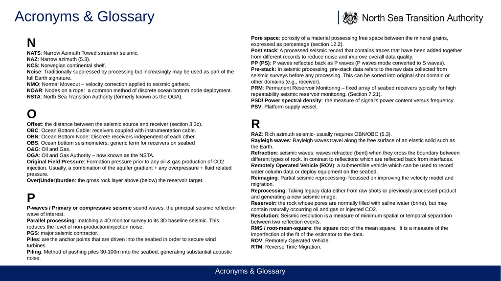
Acronyms & Glossary N
NATS: Narrow Azimuth Towed streamer seismic.
NAZ: Narrow azimuth (5.3).
NCS: Norwegian continental shelf.
Noise: Traditionally suppressed by processing but increasingly may be used as part of the full Earth signature.
NMO: Normal Moveout – velocity correction applied to seismic gathers.
NOAR: Nodes on a rope: a common method of discrete ocean bottom node deployment.
NSTA: North Sea Transition Authority (formerly known as the OGA).
O
Offset: the distance between the seismic source and receiver (section 3.3c).
OBC: Ocean Bottom Cable: receivers coupled with instrumentation cable.
OBN: Ocean Bottom Node: Discrete receivers independent of each other.
OBS: Ocean bottom seismometers: generic term for receivers on seabed
O&G: Oil and Gas.
OGA: Oil and Gas Authority – now known as the NSTA.
Original Field Pressure: Formation pressure prior to any oil & gas production of CO2 injection. Usually, a combination of the aquifer gradient + any overpressure + fluid related pressure.
Over(Under)burden: the gross rock layer above (below) the reservoir target.
P
P-waves / Primary or compressive seismic sound waves: the principal seismic reflection wave of interest.
Parallel processing: matching a 4D monitor survey to its 3D baseline seismic. This reduces the level of non-production/injection noise.
PGS: major seismic contractor.
Piles: are the anchor points that are driven into the seabed in order to secure wind turbines.
Piling: Method of pushing piles 30-100m into the seabed, generating substantial acoustic noise. Pore space: porosity of a material possessing free space between the mineral grains, expressed as percentage (section 12.2).
Post stack: A processed seismic record that contains traces that have been added together from different records to reduce noise and improve overall data quality.
PP (PS): P waves reflected back as P waves (P waves mode converted to S waves).
Pre-stack: In seismic processing, pre-stack data refers to the raw data collected from seismic surveys before any processing. This can be sorted into original shot domain or other domains (e.g., receiver).
PRM: Permanent Reservoir Monitoring – fixed array of seabed receivers typically for high repeatability seismic reservoir monitoring. (Section 7.21).
PSD/ Power spectral density: the measure of signal's power content versus frequency.
PSV: Platform supply vessel.
R
RAZ: Rich azimuth seismic- usually requires OBN/OBC (5.3).
Rayleigh waves: Rayleigh waves travel along the free surface of an elastic solid such as the Earth.
Refraction: seismic waves: waves refracted (bent) when they cross the boundary between different types of rock. In contrast to reflections which are reflected back from interfaces. Remotely Operated Vehicle (ROV): a submersible vehicle which can be used to record water column data or deploy equipment on the seabed.
Reimaging: Partial seismic reprocessing- focussed on improving the velocity model and migration.
Reprocessing: Taking legacy data either from raw shots or previously processed product and generating a new seismic image.
Reservoir: the rock whose pores are normally filled with saline water (brine), but may contain naturally occurring oil and gas or injected CO2.
Resolution: Seismic resolution is a measure of minimum spatial or temporal separation between two reflection events.
RMS / root-mean-square: the square root of the mean square. It is a measure of the imperfection of the fit of the estimator to the data.
ROV: Remotely Operated Vehicle.
RTM: Reverse Time Migration. Acronyms & Glossary<br>
NATS: Narrow Azimuth Towed streamer seismic.
NAZ: Narrow azimuth (5.3).
NCS: Norwegian continental shelf.
Noise: Traditionally suppressed by processing but increasingly may be used as part of the full Earth signature.
NMO: Normal Moveout – velocity correction applied to seismic gathers.
NOAR: Nodes on a rope: a common method of discrete ocean bottom node deployment.
NSTA: North Sea Transition Authority (formerly known as the OGA).
O
Offset: the distance between the seismic source and receiver (section 3.3c).
OBC: Ocean Bottom Cable: receivers coupled with instrumentation cable.
OBN: Ocean Bottom Node: Discrete receivers independent of each other.
OBS: Ocean bottom seismometers: generic term for receivers on seabed
O&G: Oil and Gas.
OGA: Oil and Gas Authority – now known as the NSTA.
Original Field Pressure: Formation pressure prior to any oil & gas production of CO2 injection. Usually, a combination of the aquifer gradient + any overpressure + fluid related pressure.
Over(Under)burden: the gross rock layer above (below) the reservoir target.
P
P-waves / Primary or compressive seismic sound waves: the principal seismic reflection wave of interest.
Parallel processing: matching a 4D monitor survey to its 3D baseline seismic. This reduces the level of non-production/injection noise.
PGS: major seismic contractor.
Piles: are the anchor points that are driven into the seabed in order to secure wind turbines.
Piling: Method of pushing piles 30-100m into the seabed, generating substantial acoustic noise. Pore space: porosity of a material possessing free space between the mineral grains, expressed as percentage (section 12.2).
Post stack: A processed seismic record that contains traces that have been added together from different records to reduce noise and improve overall data quality.
PP (PS): P waves reflected back as P waves (P waves mode converted to S waves).
Pre-stack: In seismic processing, pre-stack data refers to the raw data collected from seismic surveys before any processing. This can be sorted into original shot domain or other domains (e.g., receiver).
PRM: Permanent Reservoir Monitoring – fixed array of seabed receivers typically for high repeatability seismic reservoir monitoring. (Section 7.21).
PSD/ Power spectral density: the measure of signal's power content versus frequency.
PSV: Platform supply vessel.
R
RAZ: Rich azimuth seismic- usually requires OBN/OBC (5.3).
Rayleigh waves: Rayleigh waves travel along the free surface of an elastic solid such as the Earth.
Refraction: seismic waves: waves refracted (bent) when they cross the boundary between different types of rock. In contrast to reflections which are reflected back from interfaces. Remotely Operated Vehicle (ROV): a submersible vehicle which can be used to record water column data or deploy equipment on the seabed.
Reimaging: Partial seismic reprocessing- focussed on improving the velocity model and migration.
Reprocessing: Taking legacy data either from raw shots or previously processed product and generating a new seismic image.
Reservoir: the rock whose pores are normally filled with saline water (brine), but may contain naturally occurring oil and gas or injected CO2.
Resolution: Seismic resolution is a measure of minimum spatial or temporal separation between two reflection events.
RMS / root-mean-square: the square root of the mean square. It is a measure of the imperfection of the fit of the estimator to the data.
ROV: Remotely Operated Vehicle.
RTM: Reverse Time Migration. Acronyms & Glossary<br>
06
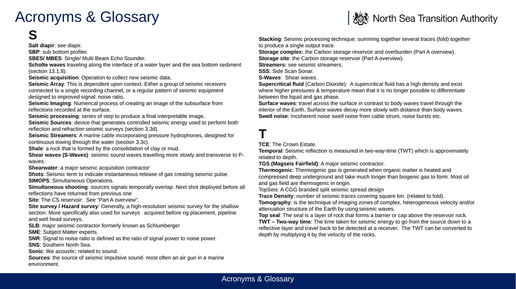
Acronyms & Glossary S
Salt diapir: see diapir.
SBP: sub bottom profiler.
SBES/ MBES: Single/ Multi Beam Echo Sounder.
Scholte waves traveling along the interface of a water layer and the sea bottom sediment (section 13.1.8).
Seismic acquisition: Operation to collect new seismic data.
Seismic Array: This is dependent upon context. Either a group of seismic receivers connected to a single recording channel, or a regular pattern of seismic equipment designed to improved signal: noise ratio.
Seismic Imaging: Numerical process of creating an image of the subsurface from reflections recorded at the surface.
Seismic processing: series of step to produce a final interpretable image.
Seismic Sources: device that generates controlled seismic energy used to perform both reflection and refraction seismic surveys (section 3.3d).
Seismic Streamers: A marine cable incorporating pressure hydrophones, designed for continuous towing through the water (section 3.3c).
Shale: a rock that is formed by the consolidation of clay or mud.
Shear waves (S-Waves): seismic sound waves travelling more slowly and transverse to P-waves.
Shearwater: a major seismic acquisition contractor
Shots: Seismic term to indicate instantaneous release of gas creating seismic pulse.
SIMOPS: Simultaneous Operations.
Simultaneous shooting: sources signals temporally overlap. Next shot deployed before all reflections have returned from previous one
Site: The CS reservoir: See “Part A overview”.
Site survey / Hazard survey: Generally, a high-resolution seismic survey for the shallow section. More specifically also used for surveys acquired before rig placement, pipeline and well head surveys.
SLB: major seismic contractor formerly known as Schlumberger
SME: Subject Matter experts.
SNR: Signal to noise ratio is defined as the ratio of signal power to noise power.
SNS: Southern North Sea.
Sonic: like acoustic: related to sound.
Sources: the source of seismic impulsive sound- most often an air gun in a marine environment. Stacking: Seismic processing technique: summing together several traces (fold) together to produce a single output trace.
Storage complex: the Carbon storage reservoir and overburden (Part A overview).
Storage site: the Carbon storage reservoir (Part A overview).
Streamers: see seismic streamers.
SSS: Side Scan Sonar.
S-Waves: Shear waves.
Supercritical fluid (Carbon Dioxide): A supercritical fluid has a high density and exist where higher pressures & temperature mean that it is no longer possible to differentiate between the liquid and gas phase.
Surface waves: travel across the surface in contrast to body waves travel through the interior of the Earth. Surface waves decay more slowly with distance than body waves.
Swell noise: Incoherent noise swell noise from cable strum, noise bursts etc.
T
TCE: The Crown Estate.
Temporal: Seismic reflection is measured in two-way-time (TWT) which is approximately related to depth.
TGS (Magseis Fairfield): A major seismic contractor.
Thermogenic: Thermogenic gas is generated when organic matter is heated and compressed deep underground and take much longer than biogenic gas to form. Most oil and gas field are thermogenic in origin.
TopSeis: A CGG branded split seismic spread design
Trace Density: number of seismic traces covering square km. (related to fold).
Tomography: is the technique of imaging zones of complex, heterogeneous velocity and/or attenuation structure of the Earth by using seismic waves.
Top seal: The seal is a layer of rock that forms a barrier or cap above the reservoir rock.
TWT – Two-way time: The time taken for seismic energy to go from the source down to a reflective layer and travel back to be detected at a receiver. The TWT can be converted to depth by multiplying it by the velocity of the rocks. Acronyms & Glossary<br>
Salt diapir: see diapir.
SBP: sub bottom profiler.
SBES/ MBES: Single/ Multi Beam Echo Sounder.
Scholte waves traveling along the interface of a water layer and the sea bottom sediment (section 13.1.8).
Seismic acquisition: Operation to collect new seismic data.
Seismic Array: This is dependent upon context. Either a group of seismic receivers connected to a single recording channel, or a regular pattern of seismic equipment designed to improved signal: noise ratio.
Seismic Imaging: Numerical process of creating an image of the subsurface from reflections recorded at the surface.
Seismic processing: series of step to produce a final interpretable image.
Seismic Sources: device that generates controlled seismic energy used to perform both reflection and refraction seismic surveys (section 3.3d).
Seismic Streamers: A marine cable incorporating pressure hydrophones, designed for continuous towing through the water (section 3.3c).
Shale: a rock that is formed by the consolidation of clay or mud.
Shear waves (S-Waves): seismic sound waves travelling more slowly and transverse to P-waves.
Shearwater: a major seismic acquisition contractor
Shots: Seismic term to indicate instantaneous release of gas creating seismic pulse.
SIMOPS: Simultaneous Operations.
Simultaneous shooting: sources signals temporally overlap. Next shot deployed before all reflections have returned from previous one
Site: The CS reservoir: See “Part A overview”.
Site survey / Hazard survey: Generally, a high-resolution seismic survey for the shallow section. More specifically also used for surveys acquired before rig placement, pipeline and well head surveys.
SLB: major seismic contractor formerly known as Schlumberger
SME: Subject Matter experts.
SNR: Signal to noise ratio is defined as the ratio of signal power to noise power.
SNS: Southern North Sea.
Sonic: like acoustic: related to sound.
Sources: the source of seismic impulsive sound- most often an air gun in a marine environment. Stacking: Seismic processing technique: summing together several traces (fold) together to produce a single output trace.
Storage complex: the Carbon storage reservoir and overburden (Part A overview).
Storage site: the Carbon storage reservoir (Part A overview).
Streamers: see seismic streamers.
SSS: Side Scan Sonar.
S-Waves: Shear waves.
Supercritical fluid (Carbon Dioxide): A supercritical fluid has a high density and exist where higher pressures & temperature mean that it is no longer possible to differentiate between the liquid and gas phase.
Surface waves: travel across the surface in contrast to body waves travel through the interior of the Earth. Surface waves decay more slowly with distance than body waves.
Swell noise: Incoherent noise swell noise from cable strum, noise bursts etc.
T
TCE: The Crown Estate.
Temporal: Seismic reflection is measured in two-way-time (TWT) which is approximately related to depth.
TGS (Magseis Fairfield): A major seismic contractor.
Thermogenic: Thermogenic gas is generated when organic matter is heated and compressed deep underground and take much longer than biogenic gas to form. Most oil and gas field are thermogenic in origin.
TopSeis: A CGG branded split seismic spread design
Trace Density: number of seismic traces covering square km. (related to fold).
Tomography: is the technique of imaging zones of complex, heterogeneous velocity and/or attenuation structure of the Earth by using seismic waves.
Top seal: The seal is a layer of rock that forms a barrier or cap above the reservoir rock.
TWT – Two-way time: The time taken for seismic energy to go from the source down to a reflective layer and travel back to be detected at a receiver. The TWT can be converted to depth by multiplying it by the velocity of the rocks. Acronyms & Glossary<br>
07
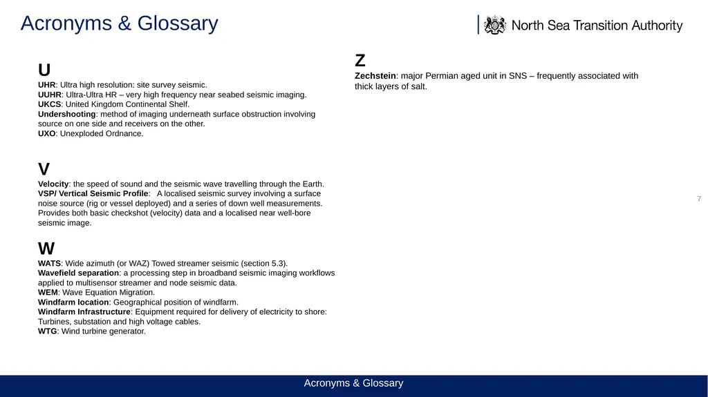
Acronyms & Glossary 7 U
UHR: Ultra high resolution: site survey seismic.
UUHR: Ultra-Ultra HR – very high frequency near seabed seismic imaging.
UKCS: United Kingdom Continental Shelf.
Undershooting: method of imaging underneath surface obstruction involving source on one side and receivers on the other.
UXO: Unexploded Ordnance.
V
Velocity: the speed of sound and the seismic wave travelling through the Earth.
VSP/ Vertical Seismic Profile: A localised seismic survey involving a surface noise source (rig or vessel deployed) and a series of down well measurements. Provides both basic checkshot (velocity) data and a localised near well-bore seismic image.
W
WATS: Wide azimuth (or WAZ) Towed streamer seismic (section 5.3).
Wavefield separation: a processing step in broadband seismic imaging workflows applied to multisensor streamer and node seismic data.
WEM: Wave Equation Migration.
Windfarm location: Geographical position of windfarm.
Windfarm Infrastructure: Equipment required for delivery of electricity to shore: Turbines, substation and high voltage cables.
WTG: Wind turbine generator. Z
Zechstein: major Permian aged unit in SNS – frequently associated with thick layers of salt. Acronyms & Glossary<br>
UHR: Ultra high resolution: site survey seismic.
UUHR: Ultra-Ultra HR – very high frequency near seabed seismic imaging.
UKCS: United Kingdom Continental Shelf.
Undershooting: method of imaging underneath surface obstruction involving source on one side and receivers on the other.
UXO: Unexploded Ordnance.
V
Velocity: the speed of sound and the seismic wave travelling through the Earth.
VSP/ Vertical Seismic Profile: A localised seismic survey involving a surface noise source (rig or vessel deployed) and a series of down well measurements. Provides both basic checkshot (velocity) data and a localised near well-bore seismic image.
W
WATS: Wide azimuth (or WAZ) Towed streamer seismic (section 5.3).
Wavefield separation: a processing step in broadband seismic imaging workflows applied to multisensor streamer and node seismic data.
WEM: Wave Equation Migration.
Windfarm location: Geographical position of windfarm.
Windfarm Infrastructure: Equipment required for delivery of electricity to shore: Turbines, substation and high voltage cables.
WTG: Wind turbine generator. Z
Zechstein: major Permian aged unit in SNS – frequently associated with thick layers of salt. Acronyms & Glossary<br>