Welcome Hon’ble Chairman & SEAC members at
Author : lindy-dunigan | Published Date : 2025-06-20
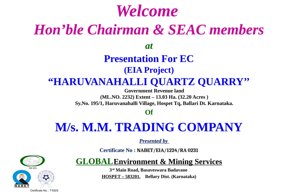
Description: Welcome Honble Chairman SEAC members at Presentation For EC EIA Project HARUVANAHALLI QUARTZ QUARRY Government Revenue land MLNO 2232 Extent 1303 Ha 3220 Acres SyNo 1951 Haruvanahalli Village Hospet Tq Ballari Dt
Presentation Embed Code
Download Presentation
Download
Presentation The PPT/PDF document
"Welcome Hon’ble Chairman & SEAC members at" is the property of its rightful owner.
Permission is granted to download and print the materials on this website for personal, non-commercial use only,
and to display it on your personal computer provided you do not modify the materials and that you retain all
copyright notices contained in the materials. By downloading content from our website, you accept the terms of
this agreement.
Transcript:Welcome Hon’ble Chairman & SEAC members at:
Welcome Hon’ble Chairman & SEAC members at Presentation For EC (EIA Project) “HARUVANAHALLI QUARTZ QUARRY’’ Government Revenue land (ML.NO. 2232) Extent – 13.03 Ha. (32.20 Acres ) Sy.No. 195/1, Haruvanahalli Village, Hospet Tq, Ballari Dt. Karnataka. Of M/s. M.M. TRADING COMPANY Presented by Certificate No : NABET/EIA/1224/RA 0231 GLOBAL Environment & Mining Services 3rd Main Road, Basaveswara Badavane HOSPET – 583201, Bellary Dist. (Karnataka) Certificate No. : T-5323 VIEW OF HARUVANAHALLI QUARTZ QUARRY INTRODUCTION & LOCATION A Haruvanahalli Quartz Mine ML .No. 2232 (Extent 13.03 Ha. (32.20 acres), Govt. Revenue land) in Survey No.195/1 Haruvanahalli Village, Hospet Tq, Ballari Dt Karnataka, is recommended to M/s. M.M Trading Company. INTRODUCTION & LOCATION STANDARD TERMS OF REFERENCE (TOR) & PUBLIC HEARING. TERMS OF REFERENCE (TOR) 5 KEY PLAN GOOGLE PLAN 1.27 km is distance from quarry to connecting tar road. The nearest village Haruvanahalli located at distance of 0.90km towards NW from the lease area. SURFACE PLAN AND TOPOGRAPHY The elevation difference is 55m. i.e, highest elevation is 625 mRL and the lowest elevation is 570 mRL. GEOLOGICAL PLAN Maximum depth of Quartz band is 48m from top of the hill. LANDUSE OF STUDY AREA List of MAJOR Plants in Study Area FAUNA IN STUDY PERIOD BASELINE INFORMATION OF STUDY AREA (DURING STUDY PERIOD DEC-2020 TO FEB-2021 27 Rainfall: The Maximum is 2.80mm rainfall in the month of April-19 and minimum rainfall of 1.40mm is observed in the month of May-19. Maximum & Minimum Relative Humidity: The humidity data collected during the study period is shows that the highest humidity 95% in Jan-2021 and lowest humidity is 23% in Feb-2021. BASELINE INFORMATION OF STUDY AREA (DURING STUDY PERIOD DEC-2020 TO FEB-2021 28 Maximum & Minimum Temperatures : The perusal of mean monthly temperature data shows that lowest & highest temperature of 0.0ºC and 23.2ºC. Wind rose Diagram of March 2019 to May 2019 BASELINE INFORMATION LANDUSE OF STUDY AREA Description of total area and percentage area for each class Table No - 4.4 Description of total area and percentage area for each class LOCATION OF MONITORING STATIONS (AMBIENT AIR, WATER, NOISE, & SOIL) SUMMARY OF AMBIENT AIR QUALITY (Period Dec - 2020 to Feb - 2021) SUMMARY OF THE NOISE LEVEL (Period Dec - 2020 to Feb - 2021) SUMMARY OF GROUND WATER & SURFACE WATER ANALYSIS (Period Dec -2020 to Feb - 2021) Summary of Ground Water Analysis Summary of Surface