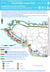
/
Baggy Point Croyde North Devon walk using the South W Baggy Point Croyde North Devon walk using the South W

Baggy Point Croyde North Devon walk using the South W - PDF document

yoshiko-marsland
yoshiko-marsland . @yoshiko-marsland
Follow
417 views
Uploaded On 2015-04-19

Baggy Point Croyde North Devon walk using the South W - PPT Presentation

From the viewpoint you can either return along the same path or follow a higher path but this involves a short steep climb and descent Due to the lack of passing places wheelchair use is not recommended past point 6 Sheep are used to help maintain t ID: 51999

From the viewpoint you

Share:

Link:

Embed:

Download Presentation from below link

Download Pdf The PPT/PDF document "Baggy Point Croyde North Devon walk usin..." is the property of its rightful owner. Permission is granted to download and print the materials on this web site for personal, non-commercial use only, and to display it on your personal computer provided you do not modify the materials and that you retain all copyright notices contained in the materials. By downloading content from our website, you accept the terms of this agreement.


Presentation Transcript

Baggy Point, Croyde, North DevonA walk using the South West Coast Path that is likely to be suitable for people with impaired mobility or with a pushchair, wheelchair, or mobility scooter. THE OFFICIAL GUIDE TO THE Key to symbols Car Park P Pub Gate ( accessible) Location of photos The Coast Path out to a viewpoint at Baggy Point (¾ mile each way) has been levelled and compacted to make access easier for everyone. From the viewpoint you can either return along the same path, or Seating Viewpoint 1 N P WC CROYDE 1 2 3 4 5 6 7 8 9 10 11 12 13 14 15 16 17 18 19 20 Woolacombe BaggyPoint Café Continuation of Coast Path (more difficult terrain) Path Surfaces: (for more details see photos overleaf) Tarmac road A reasonably smooth path with a rolled stonesurface and a gentle gradient (less than 1:10). Sections of path at least 1m wide, with a firm surface, but with a steeper gradients (more than 1:10). Stile 0 500m Sections of path with a firm surface, and gentle gradients but not suitable for wheelchair use (few passing places). This map is based on Ordnance Survey material with the permission of Ordnance Survey on behalf of the Controller of Her Majesty's Stationary Office © Crown copyright. Unauthorised reproduction infringes Crown copyright and may lead to prosecution or civil proceedings. Devon County Council. LA: 100019783.2006. The Ordnance Survey mapping is included purely to provide a contextual backdrop for the walk and cannot be used for any other purpose. One of a series of walks that can be found at www.nationaltrail.co.uk/southwestcoastpath From the National Trust car park, the Coast Path runs along a dead-end tarmac road on Just before the last house, the Coast Path leaves the tarmac road to follow a The camber on this path is generally about 1:12. The compacted stone path descends to cross a shallow valley. For about 10 metres, the camber across the path is about 1:7. The tarmac road continues for several hundred metres rising very gently. THE OFFICIAL GUIDE TO THE Baggy Point, Near Croyde 1 2 3 4 1:10 1:810m direction of slopemax gradient of slope slope across the pathmax gradient of slope Location of photos Key: 1 1:10125m 1:1075m 1:20275m 1:1240m 1:1055m 1:7 1:12 One of a series of walks that can be found at www.nationaltrail.co.uk/southwestcoastpath On the far side of the stream a one way opening gate (1.2 metres wide) is across the , before descending again. The path continues to steadily climb out towards the viewpoint on the headland. This path is approximately 1 metre wide, and between here and the viewpoint at Baggy Point there are only 2 places where it is wide enough for two wheelchairs to pass (450 metres and 620 metres from the gate), and so wheelchair use is not recommended past this point, unless you can turn within the width of the track. This is the view looking back along the path towards Croyde. When you reach the fingerpost, take a look at the steep path on the right. This is the path you will have to descend if you choose to THE OFFICIAL GUIDE TO THE Baggy Point, Near Croyde 5 6 7 8 1:10 1:810m direction of slopemax gradient of slope slope across the pathmax gradient of slope Location of photos Key: 1 1:1010m 1:1230m 1:890m 1:15100m 1.2 m One of a series of walks that can be found at www.nationaltrail.co.uk/southwestcoastpath At Pencil Rock, the exposed rock has forced the path to become narrower and this section is only 80cm wide. The last section before reaching the viewpoint crosses a slight depression. From the viewpoint at Baggy Point, you can either return back along the path you came The higher path is a steep, but relatively short climb. Part way up the slope, s stone surface from washing away have Beyond Pencil Rock the path continues to climb steadily towards Baggy Point. THE OFFICIAL GUIDE TO THE Baggy Point, Near Croyde 1:10 1:810m direction of slopemax gradient of slope slope across the pathmax gradient of slope Location of photos Key: 1 9 10 11 12 1:710 m 1:1020m 1:8100m 80 cm 1:1260m 1:15100m Viewpoint Viewpointarea Higher path 1:450m One of a series of walks that can be found at www.nationaltrail.co.uk/southwestcoastpath 50 metres before reaching the seat on the plateau, the compacted stone path ends, and Where the path goes around the corner onto the north side of the headland, the bedrock is Just around this corner is a seat, from where you get great views across Morte Bay to oolacombe and Morte Point. The Coast Path onwards from here is not particularly , (about 30cm wide) and at the next field boundary is The coast path leading northwards past the wreck post and out onto the other side of the The initial section is virtually flat, before climbing gently to THE OFFICIAL GUIDE TO THE Baggy Point, Near Croyde 1:10 1:810m direction of slopemax gradient of slope slope across the pathmax gradient of slope Location of photos Key: 1 1:6100m 1:520m 1:7200m 13 14 15 16 Seat Wreck post One of a series of walks that can be found at www.nationaltrail.co.uk/southwestcoastpath The higher path back to Croyde is along a bumpy, uneven, stone farm track. The field gate across the track swings easily, and is one-way opening. The main farm track bears inland (and is private), and the path continues onwards . The surface is a coarse, loose stone. The final section where the higher path drops down steeply to rejoin the Coast Path is, ficult on this route. The surface has loose stones and the path slopes to the The track continues to steadily descend back towards Croyde. THE OFFICIAL GUIDE TO THE Baggy Point, Near Croyde 1:10 1:810m direction of slopemax gradient of slope slope across the pathmax gradient of slope Location of photos Key: 1 1:7200m 1:10125 m 1:5150 m 1:330 m 17 18 19 20 1:7100 m 1:10175 m 1:430 m 1:6 One of a series of walks that can be found at www.nationaltrail.co.uk/southwestcoastpath