/
GIS for NG911 May 18 th , 2022 GIS for NG911 May 18 th , 2022

GIS for NG911 May 18 th , 2022 - PowerPoint Presentation

Dollface
Dollface . @Dollface
Follow
342 views
Uploaded On 2022-08-04

GIS for NG911 May 18 th , 2022 - PPT Presentation

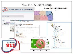
Thurston County Fairgrounds Jason Guthrie 3607042735 JasonGuthrietcomm911org Basics 911 Call Where in the world Send responders 911 Call ANI Coordinates ECRF Spatial call routing uses the calling device location to route to the correct PSAP sector based routing may sti ID: 935388

gis address ali points address gis points ali data msag call road location psap centerlines addresses spatial validation addressing

Share:

Link:

Embed:

Download Presentation from below link

Download Presentation The PPT/PDF document "GIS for NG911 May 18 th , 2022" is the property of its rightful owner. Permission is granted to download and print the materials on this web site for personal, non-commercial use only, and to display it on your personal computer provided you do not modify the materials and that you retain all copyright notices contained in the materials. By downloading content from our website, you accept the terms of this agreement.


Presentation Transcript

Slide1

GIS for NG911

May 18

th

, 2022

Thurston County Fairgrounds

Jason Guthrie 360-704-2735

Jason.Guthrie@tcomm911.org

Slide2

Basics

911 Call / Where in the world? / Send responders.

Slide3

911 Call

ANI

Coordinates

ECRF: Spatial call routing uses the calling device location to route to the correct PSAP. (sector based routing may still be used.)PSAP Polygons cover the state without gaps or overlaps

Slide4

Where in the world?

Traditional phones have a civic address (ALI) associated

Cell phones provide latitude and longitude. Handset or tower sector.

Address points are critical to converting to a dispatchable civic address.Cellular over WIFI. Associate civic address with WIFI connection.

VoIP phones have ALI as well as a VoIP Positioning Center (VPC)

Slide5

Send Responders

Fire/Law/EMS polygons cover the state without gaps or overlaps

Where the incident is located drives who should be sent.

Agency and units. (e.g.E31 or tenders)CAD picks units based on GIS data and documents the call.

Agency and perhaps station may be recommended on call handling equipment (CHE) at call setup.Where are they going. Map it!How do I get there. Route it!

Slide6

Essential GIS Layers

Address Points

Where exactly is the incident occurring? Civic address from latitude and longitude.

Need to be as comprehensive as possible.

Road CenterlinesHow do I get there from here? More detail the better (driveways?) Connectivity is important.Emergency Service Boundaries: PSAP, Fire, Law, EMSContext: Lakes, streams, railroad, communities, common places, gates, parcels, imagery, parks, schools, state/federal land, etc.

Slide7

Where does the information come from?

Addressing authorities. (Database, email, PDF, etc.)

Communication and coordination is key

Feedback on proposed addresses PSAP mapping

Documentation of address assignments and changesFeedback from first responders, GIS user, general publicCalling Service Providers (CSPs)

Slide8

GIS Data Flow

Local authoritative mapping

Data exported and uploaded to GeoComm

NENA GIS Data Model StandardComtech Spatial MSAG

CSP ALI validation (LVF)ECRFQuality Control checks at every stage!

Slide9

Questions?

If you need clarification, others probably do too.

Slide10

Why are address points important?

Reverse Geocoding

Location Validation

Addressing Clarity

Call HistoryPrecise Response Recommendation

Slide11

Reverse Geocoding

Coordinates are known as in a phase II cell call.  GIS uses these coordinates to search for the nearest civic address.

Road centerlines only give a rough approximation where good address points are likely to give you a specific, dispatchable location. 

Potentially even 3D if address points have been built out to include units on all floors. 

AVL of responding units may also show them next to a specific address.  This could be important to know if they have stopped checking in with dispatch and we need to send additional personnel to check on them.

Slide12

Location Validation

When an ALI location is validated against a spatial MSAG, it can get very specific using address points. If an address point is not found but it is road centerline valid, then the validated ALI is either incorrect or an address point is missing. 

If address points include fully parsed sub address information (building, room, floor, unit, seat), then the ALI record could store this in a standardized form instead of a free form location field.

Slide13

Addressing Clarity

Knowing where exactly each address refers to can be extremely helpful.  Even with the best of intentions, addresses may not be assigned as systematically as they should be.  Address points represent the actual addresses as they exist as opposed to an orderly and theoretic system as diagramed with road centerlines. 

Often, only one address is attached to a parcel but there may actually be several addresses in use for multiple dwelling units. 

Often, addressing authorities ask for feedback from emergency services and it can be very helpful to reference your address points, giving more meaningful feedback.  Perhaps even spur them to correct some existing errors.

Slide14

Call History

Sometimes calls are created at locations that may not have an address posted like a park or a storm pond.  With address points, the call can be created at a consistent address and history searched at this address.

Slide15

Precise Response Recommendation

Along Black Lake, there are many houses outside the city limits so the response should be the sheriff’s office and fire district 9. 

The road itself is in the city of Tumwater so if the call is on the road it should be Tumwater PD and Tumwater FD. 

With address points on structures, we can accurately identify the correct location about half a mile off the road.  With the road centerlines, the location is about 30 feet off the center and thus in the wrong jurisdiction.

Slide16

Questions?

There are no dumb questions. Well maybe some, but they are YOUR questions.

Slide17

SSAP versus RCL

Road centerlines represent the addressing system (ranges, odds/evens)

Site structure address points show precisely where the actual address is

“Fishbones” are lines that show the relationship of SSAP to the RCL Examples

Sometimes RCL does wellOften SSAP is the only way to clearly communicate where.

Slide18

Slide19

Slide20

Slide21

Slide22

Slide23

Slide24

Slide25

Slide26

Slide27

Slide28

Questions?

There must be something you are excited to ask…

Slide29

GIS Work Group Priorities

Maintain accurate and current GIS Data

Support spatial call routing.

Address points and road centerlines are the basis of the new Spatial MSAG and LVF. Run internal quality control checks to catch editing errors.

Submit data to GeoComm monthly or more frequentlyZero Critical errorsEdge matching along PSAP boundaries.

Slide30

GIS Deliverables

CPD4/S5 MSAG/Mapping/GIS Coordinators

Maintain, deliver, and improve GIS data (Road Centerlines and Address Points) for location validation (LVF).

Site Structure Address Points (SSAP) data MUST be submitted. By the end of the contract period (June 30), SSAPs published must at least be equivalent to 10% of the total number of ALI records.

To check the total SSAP required, no later than August 31 of the contract period, the GIS Coordinator will report to the SECO GIS Manager the number of ALI Records they have.ALI discrepancy reports (DR) WILL be submitted via Comtech’s ALI DBMS.90% of all Spatial MSAG location validation (LVF) change requests (CR) MUST be acknowledged within three (3) business days of being notified via email, and the remainder acknowledged within 10 business days. Acknowledgement of CRs is made by logging into the ALI DBMS and making a status change or entering a comment on CR.

Required GIS data layers pass critical quality checks and are published at least quarterly. More frequently is recommended and preferred, but not required.Participate in 66% of any scheduled GIS Workgroup meetings held during the contract period.

Slide31

Critical Errors

NGUID: Unique IDs not unique

NENA mandatory field not populated

MSAG critical fields missing values (Legacy)Invalid PSAP URI or discrepancy agency ID

Multipart geometryPolygons: Significant gaps and overlapsRCL: Range overlapsSSAP: Duplicate address points not distinguished by sub address

Slide32

Five Parts of GIS

Relatively Stable

Hardware: Need occasional refresh

Software: Routine updatesData: Continual maintenance after initial development push

Difficult to MaintainProcedures: May be stable if well documented and implemented with standard toolsPeople: Qualified people can be hard to find and expensive to train

Slide33

GIS/MSAG Coordinators

E911: Addressing authorities need to coordinate MSAG and GIS

MSAG Coordinator uses the web interface for the ALI DBMS (

Intrado

then Comtech) to maintain MSAG, ALI, and ELT for ESN. GIS Coordinator maintains map data for the PSAP to locate callers. All addresses in the ALI DB should be mappable. Not exact duplicate of MSAG.NG911: MSAG and GIS Coordinators may become the same personAddress data flows to one point of contactAddress points and road centerlines are mapped and then used as the spatial MSAG. ALI is validated against the map that will later be used to plot it during a 911 call.Emergency service boundaries are mapped out and replace ESN/ELT.

Slide34

Sharing 911 Map Data

Sharing authoritative data widely helps to prevent conflicting versions of reality and gets more eyes checking for accuracy.

Map services like Google Maps are often used for applications like those mapping 911 calls on smart phones carried by emergency personnel.

Third party

databases like HERE are often used to validate addresses when setting up WIFI calling.WAMAS is trying to maintain a Master Address Service for Washington in order to make state government more efficient and consistent.The National Address Database (NAD) is trying to assemble authoritative address data nationwide.A public facing Location Validation Function would help various people validate addresses including those used by small VoIP providers.

Slide35

Thank you for your time and attention.

Jason Guthrie

360-704-2735

Jason.Guthrie@tcomm911.org

IT System Administrator/GISThurston 9-1-1 Communications2703 Pacific Avenue SE, Suite A, Olympia, WA  98501www.tcomm911.org