PPT-Columbia River Gorge Commission Meeting
Author : alexa-scheidler | Published Date : 2018-10-10
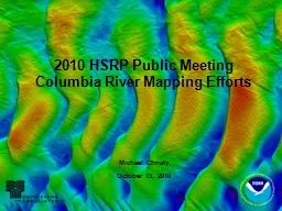
January 13 2015 Vancouver WA Air QualityVisibility Update on Columbia River Gorge Oregon Department of Environmental Quality Washington Department of Ecology Washington
Presentation Embed Code
Download Presentation
Download Presentation The PPT/PDF document "Columbia River Gorge Commission Meeting" is the property of its rightful owner. Permission is granted to download and print the materials on this website for personal, non-commercial use only, and to display it on your personal computer provided you do not modify the materials and that you retain all copyright notices contained in the materials. By downloading content from our website, you accept the terms of this agreement.
Columbia River Gorge Commission Meeting: Transcript
Download Rules Of Document
"Columbia River Gorge Commission Meeting"The content belongs to its owner. You may download and print it for personal use, without modification, and keep all copyright notices. By downloading, you agree to these terms.
Related Documents