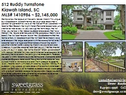
Town of Kiawah Island Municipal Center 4475 Betsy Kerrison Parkway Kiawah Island SC 29455 February 6 2019 SDP0000142018 A Preliminary Subdivision Plat Approval of Beachwalker East Parcel 13 Southern Pines Lane ROW ID: 830253
Download The PPT/PDF document "Town of Kiawah Island Planning Commissio..." is the property of its rightful owner. Permission is granted to download and print the materials on this web site for personal, non-commercial use only, and to display it on your personal computer provided you do not modify the materials and that you retain all copyright notices contained in the materials. By downloading content from our website, you accept the terms of this agreement.
Slide1
Town of Kiawah IslandPlanning Commission
Town of Kiawah Island Municipal Center4475 Betsy Kerrison ParkwayKiawah Island, SC 29455February 6, 2019
Slide2#SDP-000014-2018
A Preliminary Subdivision Plat Approval of Beachwalker East
Parcel 13 - Southern Pines Lane ROW
Applicant/Owner: Kiawah Resort Associates, LP
Surveyor: SW & A Surveying, LLC.
Parcel(s): 207-05-00-001; -118; -122; -123; 124
Zoning District: R-3/C
Acres: 22.604 (14.88 highlands)
Lot(s): 2 Lots (20.811 acres, 13.667 highlands)
2 ROWs (1.215 acres)
Insert Aerial If Necessary
Delete If Not
Slide4Insert Aerial If Necessary
Delete If Not
Slide5Insert Plat
Approved Revised Final Plat
Slide6Insert Plat
Proposed Preliminary Plat
Slide7#SDP-000014-2018
Abbreviated Time Line of Beachwalker East Parcel 13
The Planning Commission (
PC
) approved a preliminary subdivision plat at the May 2016
PC
meeting. The
PC
agreed to have the applicant come to the following June 2016
PC
meeting to address specific concerns raised (traffic, security and access).
At the June 2016 PC meeting the applicant provided a detailed explanation of the Conceptual Master Plan for Parcel 13 including the depicted circulation pattern and residential (R-3) land use pattern also affirming there will be no connection to Duneside Road.
Subsequently in the plat approval process, a conditional subdivision plat was approved by planning staff in August 2016. A revised conditional plat was approved in October 2017 conveying a portion of Parcel 12A to Parcel 13 Lot 2.
A final subdivision plat
was approved by the Planning Commission in May 2018, showing
the placement of 5’ vehicular non-access easement between Southern Pines and Duneside Road.
Slide8#SDP-000014-2018
Abbreviated Time Line of Beachwalker East Parcel
13 – Proposed Development Standards
October 4, 2018 KRA submitted a preliminary subdivision plat for review. (ref. SDP-000014-2018).
The applicant prepared a summary of proposed development standards to be linked with the submitted preliminary plat, that was to be followed with a formal agreement between KRA and KICA. The summary of proposed development standards addressed concerns raised by KICA providing assurances to minimizing future development impacts within the immediate area of Parcel 13, by self imposing restrictions during construction and occupancy of future development in the area.
November 20, 2018 KRA submitted a copy of the signed MOU between KRA/KDPII and KICA. The MOU outlines the following proposed development standards (ref. Supplementary Packet):
Southern Pines Lane ROW will terminate to a cul-de-sac with no connection to Beachwalker Road/Cape Point Road, directly or through an adjacent property.
Access and Dwelling Units
Access via Southern Pines Lane to and from Duneside Road will be provided only to Parcels 13A, 13C and a portion of 13B
“Parcel 13B Outparcel”
as shown in Exhibit B. Additionally, Parcel 13B Outparcel (north of Southern Pines Lane) shall have access limited to four (4) buildings.
Slide9Insert Plat
KRA/KDPII & KICA - MOU Exhibit B
Slide10Insert Plat
Southern Pines Lane
Duneside Road
Beachwalker Drive
Cape Point Road
KRA/KDPII & KICA - MOU Exhibit B
Parcel 13A and Parcel 13B Outparcel access Southern Pines/Duneside Road
Parcel 13A
Parcel 13B Outparcel
Cul-de-sac terminus of Southern Pines Lane with
no connection
to Cape Point/Beachwalker Drive
Parcel 13A and 13B Outparcel limited to no more than 120 residential DUs and related amenities
Additional DUs of Parcel 13B shall access via Beachwalker Drive and or Cape Point Road
Parcel 13A and Parcel 13B Outparcel access Southern Pines/Duneside Road
Abandoned 5’ vehicular non access easement
Parcel 13B Outparcel limited to no more than four (4) buildings
Slide11#SDP-000014-2018
Abbreviated Time Line of Beachwalker East Parcel 13 – Proposed
Development Standards Continued
Additional residential dwelling units within Parcel 13B shall be accessed from Beachwalker Road and or Cape Point Road and shall not have vehicular access to and from Duneside Road and or Southern Pines Lane.
The MOU defines a specific area accessible by Duneside Road/Southern Pines Lane which is limited to no more than 120 residential dwelling units and related amenities. (ref. Exhibit B)
*Current D.A. has an allotment or entitlement of 234 units for Parcel 13. Timbers Ocean Club Residences - 21 DU allocation. Parcel 13 holds a 213 remaining DU allowance.
Potential Western Kiawah Island Club
Any future west Kiawah Island “Club” located on or adjacent to Parcel 13A shall have primary access to and from Beachwalker Road but shall have the ability to offer up to thirty (30) parking spaces accessed from Duneside Road via Southern Pines Lane through Parcel 13A. This parking
shall not
tie into any portion of the club facilities that have access to Cape Point Road or Beachwalker Drive. Additional club member parking, commercial deliveries, service and employee access to and from the Club shall be via Beachwalker Road and Cape Point Road.
Slide12Insert Plat
KRA/KDPII & KICA - MOU Exhibit B
Any future KI Club on or adjacent to Parcel 13A shall have primary access to and from Beachwalker Road
Allotment of thirty (30) parking spaces accessed from Southern Pines/Duneside for a future KI Club with no internal connection of facilities accessing Cape Point Road or Beachwalker
Additional club member parking, commercial deliveries, service and employee access to and from the Club shall be via Beachwalker Road and Cape Point Road
Southern Pines Lane
Duneside Road
Beachwalker Drive
Cape Point Road
Parcel 13B Outparcel
Parcel 13A
Slide13#SDP-000014-2018
Abbreviated Time Line of Beachwalker East Parcel 13 – Proposed
Development Standards Continued
Site Development and Construction
Primary access for construction vehicles and commercial traffic associated with the site development and construction of the Club facility and residential and amenity structures within Parcels 13A and 13B Outparcel shall where feasible be via Beachwalker Road and Cape Point Road.
Access for construction vehicles and or commercial traffic via Southern Pines Lane shall be limited and utilized only when access via Beachwalker Road and Cape Point Road is not feasible under the circumstances.
Temporary connectivity to Duneside Road or Southern Pines Lane for construction or development activities on these parcels shall be blocked with appropriate fencing, bollards, or other material that prevents vehicular access to these roads.
Slide14#SDP-000014-2018
Abbreviated Time Line of Beachwalker East Parcel 13 – Proposed
Development Standards Continued
Restrictive Covenants
Should a plat be approved and recorded by the Town of Kiawah Island, KP shall execute and simultaneously record Restrictive Covenants (ref. Exhibit C) prohibiting the extension of Southern Pines Lane to provide a connection to or access from Cape Point Road/Beachwalker Road to Duneside Road.
Duneside Road Improvements
KP to contribute funds to support the design, development, and construction of pedestrian related improvements along Duneside Road to address safety concerns expressed by members of the neighboring communities.
Slide15Insert Plat
Approved Preliminary Plat
May 4, 2016
Slide16Insert Plat
Approved Conditional Plat
August 29, 2016
Slide17Insert Plat
Approved Revised Conditional Plat
October 23, 2017
Slide18Insert Plat
KRA/KDPII & KICA - MOU Exhibit B
Slide19Insert Plat
KRA/KDPII & KICA - MOU Exhibit B
Slide20#SDP-000014-2018
The Planning Department has reviewed this document for PRELIMINARY APPROVAL of this subdivision to be known as Beachwalker East and find that it is consistent with
Article 12c, Subdivision Regulations
.
Acreage Chart
Highland Acreage
Acreage Below DHEC-OCRM Setback Line
Acreage DHEC-OCRM Critical Area
Lot 1
6.724
0.276
Lot 2
6.309
6.734
Conveyance Area
0.634
0.134
Southern Pines Lane ROW
0.803
Cape
Point ROW
0.412
Cape
Point ROW Extension
0.578
Total
15.460
6.868
0.276
TOTAL ACREAGE
22.604 (including Cape Point ROW Ext.)
The subdivision request is situated at the western end of the island. The total area is approximately 22.604 acres in size containing 2 Lots (approximately 13.667 highland acres) and 2 Right-of-Ways (approximately 1.215 acres)
The proposed Southern Pines ROW alters the currently approved final plat for the area by proposing the connection of the existing Duneside Road to the existing Southern Pines Lane along with disconnecting Southern Pines Lane with Cape Point. The terminus of Southern Pines Lane proposes a circular turnaround at the western end.
Slide21#SDP-000014-2018
The Planning Department has reviewed this document for PRELIMINARY APPROVAL of this subdivision to be known as Beachwalker East and find that it is consistent with
Article 12c, Subdivision Regulations
.
In the event the Planning Commission decides to approve the application for Preliminary Approval of the subdivision to be known as Beachwalker East (TMS# 207-05-00-0011; -118; -122; -123; -124) the planning department asks the Planning Commission to consider the following conditions:
Prior to approval of the
final
plat, the current approved Access and Construction Easement designated to and from Southern Pines Lane to Lot 3 of Parcel 13 via Cape Point shall be amended to acknowledge an appropriate and alternative vehicular access to and from Southern Pines Lane to Lot 3 and future development of Parcel 13 via Duneside Road.
The subject preliminary plat and sequential approved plats shall be noted with the development provisions outlined by the referenced MOU between Kiawah Resort Associates, LP (KRA) and the Kiawah Island Community Association (KICA), referencing the signed MOU exhibit that depicts future development patterns for the area.
Slide22#SDP-000014-2018
Abbreviated Time Line Since December 5
th
Planning Commission Meeting
October 4, 2018 KRA submitted a preliminary subdivision plat for review. (ref. SDP-000014-2018).
November 20, 2018 KRA submitted a copy of the signed MOU between KP and KICA highlighting specific development standards for Parcel 13.
At the
December 5, 2018
Planning Commission (
PC
) meeting, the applicant and the
PC
mutually agreed to reconvene on January 24, 2019 to revisit the application after an independent traffic and safety study was completed.
The Town contracted with
Kimley-Horn
to complete the requested traffic and safety study.
To provide all interested parties sufficient time to review the completed study, the applicant and
PC
mutually agreed to reconvene at the scheduled
February 6
th
PC
meeting
.
Slide23#SDP-000014-2018
Abbreviated Time Line Since December 5
th
Planning Commission Meeting
The traffic and safety study produced two general findings:
T
here does not appear to be capacity concerns with allowing a connection from Duneside Road onto Southern Pines Lane
in any of the three alternatives analyzed.
There are
pedestrian, vehicular, and bicycle safety concerns that should be addressed along both Duneside Road and Southern Pines Lane.
“
West Beach Community Areawide Improvements
” exhibit provided by the applicant.
50+ public comments letters
received.
Slide24Duneside Traffic & Safety Study Presentation
Kimley-Horn
Slide25Insert Plat
Proposed Preliminary Plat