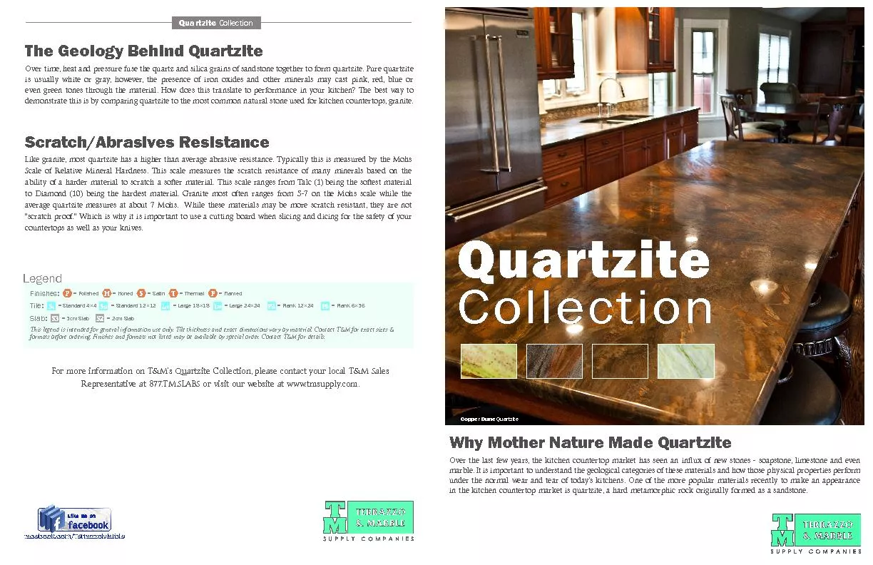
/
Gully Initiation on the Quartzite Ridges of Ibadan, South West, Nigeria Gully Initiation on the Quartzite Ridges of Ibadan, South West, Nigeria

Gully Initiation on the Quartzite Ridges of Ibadan, South West, Nigeria - PowerPoint Presentation

belinda
belinda . @belinda
Follow
65 views
Uploaded On 2023-10-26

Gully Initiation on the Quartzite Ridges of Ibadan, South West, Nigeria - PPT Presentation

1 Fashae Olutoyin Adeola 1 Obateru Rotimi Oluseyi 1 Olusola Adeyemi Oludapo 1 Department of Geography University of Ibadan Nigeria INTRODUCTION Patton and Schumm 1975 ID: 1024833

soil gully gullies amp gully soil amp gullies development 2012 relationship area sectional initiation ridges erosion ibadan sar esp

Share:

Link:

Embed:

Download Presentation from below link

Download Presentation The PPT/PDF document "Gully Initiation on the Quartzite Ridges..." is the property of its rightful owner. Permission is granted to download and print the materials on this web site for personal, non-commercial use only, and to display it on your personal computer provided you do not modify the materials and that you retain all copyright notices contained in the materials. By downloading content from our website, you accept the terms of this agreement.


Presentation Transcript

1. Gully Initiation on the Quartzite Ridges of Ibadan, South West, Nigeria1Fashae Olutoyin Adeola, 1Obateru Rotimi Oluseyi, 1Olusola Adeyemi Oludapo1Department of Geography, University of Ibadan, Nigeria.

2. INTRODUCTIONPatton and Schumm, 1975; Imeson and Kwaad, 1980; Poesen et al. 2003- Gullies occur when a geomorphologic threshold is exceeded.Schumm et al. (1974) ,Poesen et al. (2002), Zhu, 2012, Vendrusculo, 2014, Menendez-Duartz et al., Kumar et al. (2020), Poesen (1993) – reveals it occurs in several climes, caused by several factors with varying characteristics.And so many other definitions……..But all definitions point to the fact that Gullies are characterized by: 1. Depressions greater than rills . 2. Their development is initiated by the action of concentrated overland flow on soil materials.

3. GULLY EROSION STUDIES FROM NIGERIAOkagbue and Uma, 1987)- Examined the different dimensions/forms of Gullies on the Southeastern sedimentary basin.Several other studies (Ofomata, 1965; Nwajide and Hoque, 1979; Henry et al. 2016) – Affirmed the role of soil and geology on the process of gully evolution, still in the SE sedimentary basin.Adediji, et al. (2013), Faniran and Areola, 1974; Conforti, et al. 2011- concluded that human activities are responsible for gully initiation and acceleration on the basement complex terrains of southwestern regions.

4. Why study Gully erosion on the Basement complex of NigeriaGullying processes on the sedimentary terrain have received significant attention from researchers while such processes are often overlooked in the Basement Complex areas because of their perceived resistance to denudation.

5. Aim and Objectives Aim – Assess the development and the initiation of gully erosion on the quartzite ridges of Ibadan, Nigeria. Objectives :assess the morphological characteristics of gullies on the quartzite ridges, and examine the factors of gully development on the ridges and their relationship with gully morphology.

6. Study areaThe study sites are Mokola ridge, Mapo ridge and Eleyele Hill – All in Ibadan.The geomorphology of Ibadan – consists of HILLS, PLAINS & VALLEYS.Rainfall-Elevation -174 m and 365 m above sea levelIbadan is underlained by Basement Complex rocks which mainly consist of the metamorphic rock types of Pre-Cambrian age, but with some intrusions of granites and porphyrite of Jurassic age. The Hills / Ridges are Quartzitic with intrusions of some schist.

7. Field MeasurementGully length, width & depth were measured at an interval of 5 metres with a measuring tapeGully slope was measured using abney level and ranging poles. Soil samples at depth 0 – 15 cm was collected from each gully section using soil auger and core sampler. Soil samples were kept in opaque cellophane bags to preserve their original properties while they are being transported to the laboratory for analyses. Photographic shots and coordinates of the gullies would be obtained using digital camera and Global Positioning System (GPS).

8. Morphological characterizationDerived variablesFormulaeCross-sectional area (Ehiorobo and Audu, 2012)Where, A = gully cross-sectional area, h = depth of gully, b = gully breadth, and s = side slopeGully Volume/Soil loss (VL) (Schoffield, 1993)Where, Where, VL = volume of soil loss between the sections; A1 = cross-sectional area of the first section; A2 = cross-sectional area of the second section; and Am = cross-sectional area of section mid-way between first and second sections.Gully density (D) (Gawrysiak L, Harasimiuk, 2012) Gully frequency (F) (Gawrysiak and Harasimiuk, 2012) Gully shape (Xu et al. 2012)Derived variablesFormulaeCross-sectional areaGully Volume/Soil loss (VL)Gully density (D)Gully frequency (F)Gully shape

9. Laboratory and Statistical AnalysesThe soil samples were analyzed in the laboratory for pH, Electrical conductivity (EC), organic matter (OM), sodium absorption ratio (SAR), and exchangeable sodium percentage (ESP) using standard laboratory procedures.Spearman Rank Correlation was used to infer the relationship between variables.

10. Table 1. Characterization of Gully Systems on Quartzite Ridges in IbadanGully SystemGully SiteAltitude (m)Wmax (m)Wav(m)Dmax (m)Dav (m)L (m)Straight Length (m)Wb (m)OrderMokola HillMk 1235.602.762.031.741.1839.4031.500.601Mk 2241.201.210.820.960.855.985.710.711244.100.910.510.910.755.204.200.421246.708.305.701.601.5610.109.605.202Mk 3221.705.124.522.402.213.9012.802.471237.601.711.641.661.6224.8022.701.601213.705.705.503.122.9548.3038.704.902Mk 4234.404.904.851.211.140.5037.905.402Mk 5241.106.235.702.241.9350.2039.403.301192.2026.4025.38.167.1529.2026.1023.402224.803.883.625.524.850.2049.400.983Mapo RidgeKB 1197.302.802.571.401.239.5927.302.2312.202.101.341.262.101.901.8025.415.871.851.680.2372.621.621KB 2187.504.274.111.301.110.369.544.0113.453.213.483.3218.1013.202.9027.256.423.753.4265.6958.216.20130.1029.002.1028.876.1228.101ID 1133.702.412.311.300.926.8018.602.1112.492.320.910.958.1032.602.2026.095.883.30319.8014.205.702Eleyele HillEL 1190.301.861.731.561.437.9141.700.841EL 2191.602.041.401.651.4382.0083.400.651

11. Figure 1. Mokola hill gully system

12. Figure 2. Gully morphology at Eleyele Hill

13. Figure 3. Soil textural composition, pH & Exchangeable acidity of the gully systems

14. Figure 4. Organic matter, electrical conductivity (EC), sodium absorption ratio (SAR) & exchangeable sodium percentage (ESP).

15. Factors of Gully DevelopmentTopography – Gentle sloping concave valley side of the ridge.Lineament – lines of weaknessSoil properties – Sodic composition (SAR & ESP) and high EC.Land use – Improper land use, footpaths, bush burning, farming, construction.

16. Relationship between morphology and gully developmentThe relationship between topography and gully development was asserted by identifying the degree of association between hill slope elevation and gully width/depth ratio. Correlation analysis returned a negative coefficient of r = -0.462 (p < 0.05). Therefore, there is an inverse relationship between the altitude and gully development. The occurrence of the gullies on gentle slopes of the ridges is supported by the findings of Le Roux and Sumner (2012); Tamene et al. (2006); Kakembo et al. (2009)SAR (r = 0.794) and ESP (r = 0.867) are positively correlated with gully cross-sectional area (p < 0.05). Organic matter content and electrical conductivity are not statistically significant (p > 0.05). Similarly, strong positive relationship was observed between SAR (r = 0.758, p < 0.05), ESP (r = 0.661, p < 0.05) and gully volume at 0.05 level of significance. This suggests that sodic rich mineral content of the parent material of the gully systems exact strong influence on the process of gully development. This inference is in line with previous researches conducted by Poesen et al. (2002), Romero Diaz et al. (2007) and Samani et al. (2008).

17. Relationship between morphology and gully development cont’dFrom the results, we posit that gullies formed on gentle slopes are usually characterised by wide and U-shaped channels. These gullies are largely discontinuous, not too deep, and their slope ranges between 30 - 70. Whereas, the gullies on the steep slope (150 - 300) are crusted with bedrocks that are characterised by deep and narrow channels.The relationship between SAR and ESP suggests that sodic soils encourage gully initiation. This implies that gully initiation processes are dominant on gently sloping terrain due to the availability of large surface area and weathered regolith that will enhance fluvial processes of material detachment on the one hand and subsurface processes like piping on the other hand.

18. CONCLUSIONAs observed from the study, topography, lineament, soil properties and human activities encourage the initiation and development of the gullies. Also, the study concluded that the presence of excessive amounts of exchangeable sodium reverses the process of compaction and causes soil aggregates to disperse into their constituent individual soil particles. And finally, further geomorphological assessment of landform units in Ibadan is necessary with a view of identifying potential geomorphic risk prone areas, an essential component of risk management of the dense urban areas of the humid tropics.

19. REFERENCESEhiorobo, J.O. & Audu, H.A.P. (2012). Monitoring of Gully Erosion in an Urban Area Using Geoinformation Technology. Journal of Emerging Trends in Engineering and Applied Sciences (JETEAS) 3 (2): 270-275Gawrysiak, L. & Harasimiuk, M. (2012). Spatial diversity of gully density of the Lublin Upland and Roztocze Hills (SE Poland). Ann UMCS 67:27–43. Kakembo, V., Xanga, W.W. & Rowntree, K. (2009). Topographic thresholds in gully development on the hillslopes of communal areas in Ngqushwa Local Municipality, Eastern Cape, South Africa. Geomorphology 110: 188–194.Le Roux, J. J. & Sumner, P. D. (2012). Factors controlling gully development: comparing continuous and discontinuous gullies. Land Degradation & Development, 23(5), 440-449.Menéndez-Duarte, R. Marquínez, J. Fernández-Menéndez, S. & Santos, R. (2007). Incised channels and gully erosion in Northern Iberian Peninsula: Controls and geomorphic setting. Catena, 71(2), 267-278Poesen, J. Vandekerckhove, L. Nachtergaele, J. Oostwoud Wijdenes, D. Verstraeten, G. van Wesemael, B. (2002). Gully erosion in dryland environments. In: Bull, L.J. Kirkby, M.J. (Eds.), Dryland Rivers: Hydrology and Geomorphology of Semi-Arid Channels. Wiley, Chichester, UK, pp. 229–262.Romero Diaz, A. P. Marin Sanleandro, A. Sanchez Soriano, F. Belmonte Serrato, H. Faulkner, (2007). The causes of piping in a set of abandoned agricultural terraces in southeast Spain. Catena 69, 282-293.Rowntree, K.M. (1991) Morphological characteristics of gully networks and their relationship to Host Materials, Baringo District, Kenya. GeoJournal 23.1 19-27. Samani, A.A. Nazari, H. Ahmadi, M. Jafari, J. Ghoddousi (2008). Effect of incipient gullying mechanisms on topographic threshold conditions for gully initiation in southwestern Iran (Boushehr-Samal watershed). DESERT 13 (2008) 31-43Schoffield, W. (1993). Engineering Surveying. Butterworth – Heineman Ltd, Oxford U.KTamene, L., Park, S.J., Dikau, R. & Vlek, P.L.G. (2006). Analysis of factors determining sediment yield variability in the highlands of northern Ethiopia. Geomorphology 76: 76– 91.Xu, Z., Fachao, Q., Bin, Z., Qingchun, D., Hui, L., Jie, J., & Liangtao, S. (2012). The morphological characteristics of gully systems and watersheds in Dry-Hot Valley, SW China. Acta Geochim. https://doi.org/10.1007/s11631-018-0299-y

20. toyinafashae@yahoo.com