/
Measuring and Describing Outcrops That You Can’t Actually Touch Measuring and Describing Outcrops That You Can’t Actually Touch

Measuring and Describing Outcrops That You Can’t Actually Touch - PDF document

calandra-battersby
calandra-battersby . @calandra-battersby
Follow
383 views
Uploaded On 2016-07-04

Measuring and Describing Outcrops That You Can’t Actually Touch - PPT Presentation

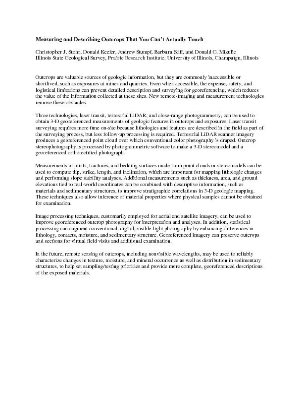
Christopher J Stohr Donald Keefer Andrew Stumpf Barbara Stiff and Donald G Mikulic Illinois State Geological Survey Prairie Research Institute University of Illinois Champaign Illinois ID: 389960

Christopher Stohr Donald Keefer

Share:

Link:

Embed:

Download Presentation from below link

Download Pdf The PPT/PDF document "Measuring and Describing Outcrops That Y..." is the property of its rightful owner. Permission is granted to download and print the materials on this web site for personal, non-commercial use only, and to display it on your personal computer provided you do not modify the materials and that you retain all copyright notices contained in the materials. By downloading content from our website, you accept the terms of this agreement.


Presentation Transcript

Measuring and Describing Outcrops That You Can’t Actually Touch Christopher J. Stohr, Donald Keefer, Andrew Stumpf, Barbara Stiff, and Donald G. Mikulic Illinois State Geological Survey, Prairie Research Institute, University of Illinois, Champaign, Illinois Outcrops are valuable sources of geologic information, but they are commonly inaccessible or shortlived, such as exposures at mines and quarries. Even when accessible, the expense, safety, and logistical limit ations can prevent detailed description and surveying for georeferencing, which reduces the value of the information collected at these sites. New remote - imaging and measurement technologies remove these obstacles. Three technologies, laser transit, terr estrial LiDAR, and close - range photogrammetry, can be used to obtain 3 - D georeferenced measurements of geologic features in outcrops and exposures. Laser transit surveying requires more time on - site because lithologies and features are described in the fiel d as part of the surveying process, but less follow - up processing is required. Terrestrial LiDAR scanner imagery produces a georeferenced point cloud over which conventional color photography is draped. Outcrop stereophotography is processed by photogramme tric software to make a 3 - D stereomodel and a georeferenced orthorectified photograph. Measurements of joints, fractures, and bedding surfaces made from point clouds or stereomodels can be used to compute dip, strike, length, and inclination, which are i mportant for mapping lithologic changes and performing slope stability analyses. Additional measurements such as thickness, area, and ground elevations tied to real - world coordinates can be combined with descriptive information, such as materials and sedim entary structures, to improve stratigraphic correlations in 3 - D geologic mapping. These techniques also allow inference of material properties where physical samples cannot be obtained for examination. Image processing techniques, customarily employed fo r aerial and satellite imagery, can be used to improve georeferenced outcrop photography for interpretation and analyses. In addition, statistical processing can augment conventional, digital, visible - light photography by enhancing differences in lithology , contacts, moisture, and sedimentary structure. Georeferenced imagery can preserve outcrops and sections for virtual field visits and additional examination. In the future, remote sensing of outcrops, including nonvisible wavelengths, may be used to rel iably characterize changes in texture, moisture, and mineral occurrence as well as distribution in sedimentary structures, to help set sampling/testing priorities and provide more complete, georeferenced descriptions of the exposed materials.