/
Opelousas, Gulf and Northern Railroad “Rails to Trails” Opelousas, Gulf and Northern Railroad “Rails to Trails”

Opelousas, Gulf and Northern Railroad “Rails to Trails” - PowerPoint Presentation

calandra-battersby
calandra-battersby . @calandra-battersby
Follow
345 views
Uploaded On 2019-11-21

Opelousas, Gulf and Northern Railroad “Rails to Trails” - PPT Presentation

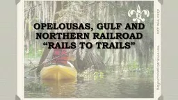
Opelousas Gulf and Northern Railroad Rails to Trails Route of the Original OG TRACK from Melville LA to Port Barre LA Transverses the upper western side of the Atchafalaya Basin Terminus at the Atchafalaya River in Melville ID: 766328

lake atchafalaya port bayou atchafalaya lake bayou port area points baton barre rouge railway melville bayous parish hiking club

Share:

Link:

Embed:

Download Presentation from below link

Download Presentation The PPT/PDF document "Opelousas, Gulf and Northern Railroad ..." is the property of its rightful owner. Permission is granted to download and print the materials on this web site for personal, non-commercial use only, and to display it on your personal computer provided you do not modify the materials and that you retain all copyright notices contained in the materials. By downloading content from our website, you accept the terms of this agreement.


Presentation Transcript

Opelousas, Gulf and Northern Railroad “Rails to Trails”

Route of the Original “OG TRACK” from Melville, LA, to Port Barre, LA Transverses the upper western side of the Atchafalaya Basin Terminus at the Atchafalaya River in Melville Terminus at the banks of Bayou Teche and Bayou Cortableau in Port Barre

Deep local historical significance for this area Unspoiled beauty of bayous, swamps, heavy forests 15.8 miles of trail, most of it currently maintained by the local and parish governments Multiple easy access points Can be tied into other areas in surrounding parishes

Tremendous appeal for outdoor enthusiasts for camping, boating, fishing, hiking, exploring and biking A great opportunity to educate about American Indians, the Acadians, shipping, and the social and economic relevance of the railway The well developed railway base and the greatly undeveloped area is conducive to an easily transformed public recreational gem

Remnants of the old railway are still visible Several key crossings of bayous have pilings that can likely still be used

Crossings

Pilings visible

Benefits Easily developed access points are key Melville, Old Ferry Ramp Second Lake Pleasure Club Depot Location, WPA Road US Hwy 71 Port Barre, Bayou Cortableau Crossing

Native American Presence Second Lake Pleasure Club Depot, an early 1900s Rod and Gun Club Paddlewheel shipping route Swayze Lake, location of the famous Dunbar child kidnapping The Railway as a investor based alternative for shipping to Memphis and Baton Rouge SELLING POINTS Enthusiastic support among landowners, community leaders and the area business owners Ties directly into the Bayou Teche Water Trail Is strategically located an hour from Alexandria, Lafayette and Baton Rouge

Recreational Opportunities Camping Water Skiing Fishing Hiking Photography Cycling SELLING POINTS Showcases northeastern St. Landry Parish Intimate Atchafalaya experience Revolutionary economic impact for Melville and Port Barre and all of St. Landry Parish

impediments 5 Hiking/Biking Bridges would be necessary for crossing bayous State Canal Side Lake Second Lake Half Moon Bayou Levee Barrow Pit near Hwy 71

Steven Fullen | Executive Director Atchafalaya National Heritage Area Office of Lt. Governor Billy Nungesser Louisiana Department of Culture, Recreation & Tourism Mail: P.O. Box 44243, Baton Rouge, LA 70804-4243 Courier: 1051 N. Third St., Room B-20, Baton Rouge, LA 70802 Phone: 225.219.0768 Fax: 225. 219.3010 Email: sfullen@crt.la.gov Website: Atchafalaya.org