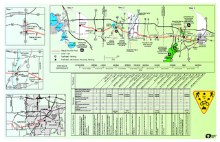
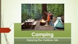
/
SOUTHERN UNITKETTLE MORAINESTATE FOREST(Camping, swimming,picnicing, w SOUTHERN UNITKETTLE MORAINESTATE FOREST(Camping, swimming,picnicing, w

SOUTHERN UNITKETTLE MORAINESTATE FOREST(Camping, swimming,picnicing, w - PDF document

calandra-battersby
calandra-battersby . @calandra-battersby
Follow
383 views
Uploaded On 2015-07-28

SOUTHERN UNITKETTLE MORAINESTATE FOREST(Camping, swimming,picnicing, w - PPT Presentation

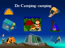
PARKSANCTUARY DANE COJEFFERSON COJEFFERSON COWAUKESHA CO Glacial Drumlin TrailOther Trail PinewoodsCampground 0 05 km5 mi L MendotaL MononaLWaubesaL KegonsaRockLCrawfish Rock 12 51 12 51 1 ID: 95738

PARKSANCTUARY DANE CO.JEFFERSON CO.JEFFERSON CO.WAUKESHA CO. Glacial

Share:

Link:

Embed:

Download Presentation from below link

Download Pdf The PPT/PDF document "SOUTHERN UNITKETTLE MORAINESTATE FOREST(..." is the property of its rightful owner. Permission is granted to download and print the materials on this web site for personal, non-commercial use only, and to display it on your personal computer provided you do not modify the materials and that you retain all copyright notices contained in the materials. By downloading content from our website, you accept the terms of this agreement.


Presentation Transcript

SOUTHERN UNITKETTLE MORAINESTATE FOREST(Camping, swimming,picnicing, water)LAPHAM PEAK UNITKETTLE MORAINESTATE FOREST(Water, picnicing,backpack camping)AZTALANSTATE PARK(Water, picnicing,no camping)SANDHILLSTATION STATECAMPGROUNDPOHLMAN CO. PARK(Water, picnicing,no camping)LAKE KEGONSASTATE PARK(Camping, picnicing,water, swimming) PARKSANCTUARY DANE CO.JEFFERSON CO.JEFFERSON CO.WAUKESHA CO. Glacial Drumlin TrailOther Trail PinewoodsCampground 0 05 km5 mi L. MendotaL. MononaL.WaubesaL. KegonsaRockL.Crawfish Rock 12 51 12 51 12 151 12 151 12 12 12 18 12 18 12 18 12 18 43 94 43 94 43 94 43 90 43 90 43 90 73 89 26 67 83 164 83 59 59 59 67 26 89OA Y D D P E C C G G D E E DE TT X X G P F F YAA N NQ NQ 73 134 134 30OWaterville Rd.Switzke Rd.Sunset Dr.Mickle Rd. Madison KORTHPARK 6.7 mi / 10.8 km3.2 mi / 5.1 km5.8 mi / 9.3 km5.5 mi / 8.9 km3.5 mi / 5.6 km2.1 mi /3.4 km5.9 mi / 9.5 km5.8 mi / 9.3 km5.4 mi / 8.7 km6.5 mi / 10.5 kmCOTTAGE GROVEDEERFIELDLONDONLAKE MILLSJEFFERSONSWITZKE RD.HELENVILLESULLIVANDOUSMANWALESWAUKESHADISTANCEREFERENCE WAUKESHBrandy BrookMcArthur Rd.SentryPrairieFox R. 94 94 TT G X TT 18 18 18 59 59Sunset ParkE.B. Shurts EnvironmentalLearningCenter Meadowbrook Rd.Summit Ave.W. St. Paul Ave. Grandview Blvd.Pewaukee Rd. Elmhurst Rd. Main St. ClarkSt. BB BB N TT N 94 94Rest Rooms Junction Rd. Switzke Rd. JEFFERSON Y Y 26 18 18 BGlacialDrumlinTrailMarsh Rd. 94 94JOHNSONCREEKRock RiverJahn Rd. OverpassIndian Head Rd.Schreiber Ln.Tower Rd. N 26 BUS26 PRINTED NRECYCLEDPAPER TrailheadCottage Grove 200 S. Main St, 53527 Deerfield 212 N. Main St, 53531 London Holly Ridge Ln, Cambridge, 53523Korth Park W8390 Cty Hwy S, Lake Mills, 53551Lake Mills 1213 S. Main St, 53551Jefferson Junction N5322 Schreiber Ln, Johnson Creek, 53038 HelenvilleOn Helenville Rd, North of US Hwy 18Pohlmann ParkN4809 Duck Creek Rd, Helenville, 53137Sullivan907 Front St, 53178Dousman On Main St @ Elm St, 53118Delafield On US Hwy 18 @ Cushing Park Rd, 53018WalesOn James St @Universal St, 53183County Highway TTBetween McArthur Rd and Sunset Dr, 53188McArthur Road 2101 McArthur Rd, Waukesha, 53188Sunset ParkS30 W28452 Sunset Dr, Waukesha, 53188Waukesha 810 College Ave, Waukesha 53188Services DNR Trail Pass Self-Pay StationAuthorized Trail Pass VendorParking AreaBike Rentals*Bike Repair*Drinking Water (Seasonal)Restrooms (Seasonal)Picnic Areagas*DNR Campground/CampsiteLodging*Restaurant/Bar & Grill*Groceries*Local trails that connect to GDTLocation Description**Some trailheads and other trails that connect to the GDT are operated by agencies other than WI DNR. Please obey their rules and regulaltions for usage of those facilities. *As of this printingServicesFollow State Highway 89 to County Highway A. Look for the train depot.Follow signage off of Hwy 26 (Exit Business 26).Trailhead is on County Highway D north of US Highway 18.**http://www.jeffersoncountywi.govTrailhead is directly across from the Post Office on County Highway N. See http://www.cityofmadison.com/bikeMadison/ for biking to MadisonGlacial River TrailKorth Park TrailsFt AtkinsonFt AtkinsonTrailhead is on State Highway 73 on the north edge of downtown.Take State Highway 134 (County Highway O) to Main St. Trail parking is on Holly Ridge north of Main. CambridgeCambridgeNext to 6 St. Paul Bus Stop http://www.ci.waukesha.wi.us/waukeshametro/rt6_main**Trailhead is Sunset Park on Sunset Drive 1 mile west of County Highway TT. http://www.towngenesee.org/**Trailhead is at E.B. Shurts Enviornmental Learning Center in the Fox River Sanctuary.Trailhead is on Palmyra Street south of US Highway 18.Trailhead is on Main Street south of US Highway 18.This trail connects the GDT to Lapham Peak and Delafield.Trailhead is on James Street 5 blocks east of Main Street.**Trail parking and access to the trail is in Korth Park. http://www.jeffersoncountywi.govLake Mills Dousman Dousman Cushing Park TrailFox River TrailDelafield WaukeshaWaukeshaDelafield Map 1Map 2Map 3Map 1Map 2Map 3 YIELD