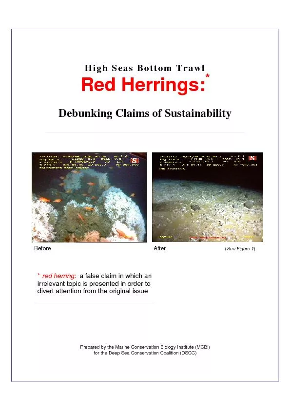
/
Geog 126: Maps in Science and SocietyCartographic Red Herrings: Frobis Geog 126: Maps in Science and SocietyCartographic Red Herrings: Frobis

Geog 126: Maps in Science and SocietyCartographic Red Herrings: Frobis - PDF document

celsa-spraggs
celsa-spraggs . @celsa-spraggs
Follow
383 views
Uploaded On 2016-03-04

Geog 126: Maps in Science and SocietyCartographic Red Herrings: Frobis - PPT Presentation

147Somebody had blundered148Dishonest cartographyMistakesStupidityIgnoranceAstonishing persistenceIrrational belief Some examplesFrobishers Gold and the North West PassageThe strait of Anian and ID: 241034

“Somebody had blundered”Dishonest cartographyMistakesStupidityIgnoranceAstonishing persistenceIrrational

Share:

Link:

Embed:

Download Presentation from below link

Download Pdf The PPT/PDF document "Geog 126: Maps in Science and SocietyCar..." is the property of its rightful owner. Permission is granted to download and print the materials on this web site for personal, non-commercial use only, and to display it on your personal computer provided you do not modify the materials and that you retain all copyright notices contained in the materials. By downloading content from our website, you accept the terms of this agreement.


Presentation Transcript

Geog 126: Maps in Science and SocietyCartographic Red Herrings: Frobisher’s Gold, Inland Seas and Frisland Topic 4: Perceptions of Foreign LandsThe age of exploration and the expansion of nation states increased knowledge of foreign lands and peoplesHowever, historical stereotypes and misconceptions persisted for centuriesPerception is not always reality, bias, misinformation and ignorance can lead to false impressions “Somebody had blundered”Massive geographical ignoranceDishonest cartographyMistakes and deliberate falsehoodsStupidityIgnoranceAstonishing persistenceIrrational belief ap accompanying Thomas J. Maslen’s The Friend of Australia (1830) Three examplesFrobishersGold and the North West PassageThe straits of Anianand the Inland SeaFrislandand the Zeno Brothers Sir Martin Frobisher(c. 1535 or 1539 November 22, 1594) Map of the New World: 1540 The Irony: It does exist! Frobisher Bay The World View First VoyageIn search of a Northwest Passage as a traderoute to India and China (referred to at that time as Cathay).After 15 years, in 1576 Frobisher convinced the Muscovy Company to license his expedition (first major chartered joint stock company)Three barks: the GabrielMichael,25 tons each, and a pinnace of ten tons, with a total crew of 35, left Blackwall, via the Shetland Is.28 July, with only Michael left: sighted landReached Frobisher Bay "whether he might carry himself through the same into some open sea on the back side."Baffin Island reached 18 August 1576Took on a native guide. Several crew held hostage, none returned.Returned to London on 9 October. Returned with a "piece of a black stone"Assayers were unimpressed Muscovy Company used this assessment to lobby for investment for another voyage “Company of Cathay” Second VoyageElizabeth I sold the Royal Navy ship Aydeto the Company of Cathay and gave £1000 and a royal charterCompany had exclusive right of sailing in every direction but east. Frobisher appointed high admiral of all lands and waters that might be discovered Ayde, GabrielMichael, with 150 men, including miners, refiners, gentlemen, and soldiers left 25 May 1577 Sailed north of Scotland reached Hall's Island at the mouth of Frobisher Bay on 17 July. Took possession in the queen's name."defer the further discovery of the passage until another time.“Parley and skirmishing with the natives, did not recover the men captured the previous year.Aydereached Milford Haven on 23 September. The GabrielMichaellater arrived separately at Bristol and Yarmouth.Frobisher was received and thanked by the queen at WindsorMuch fuss about the 200 tons of ore. Disputes begin. The Ayde: 200 tons Black Stone: Fools Gold Lapworth Museum, U. Birmingham Third VoyageElizabeth named new land MetaIncognitaSought a new expedition to establish of a colony of 100 menLeft Harwich 30 June 1578 with fifteen vesselsStopped at south of GreenlandFrobisher Bay was sighted July 2nd. Stormy weather wrecked the barqueDennisand drove the fleet into a new strait (Hudson). Sailed sixty miles up this "mistaken strait," then returned to Frobisher Bay.Tried to create settlement, but dissension and discontent Returned August to OctoberThe ore was taken to a specially constructed smelting plant at Powder Mill Lane in Deptford, Kent. Despite many attempts, the ore was apparently not worth smelting and was eventually used in Elizabethan road construction Countess of Warwick's Island, now Kodlunarn Island. Ship trench Reservoir trench Title page of Hakluyt's (1589) account of Frobisher's voyages The value: Best’s narrative Smelting Later travelsWent to sea with a trading expedition sailing to the Guinea coast of AfricaThe following year on another expedition to Guinea he was held hostage for several months before being freedBy 1565, he is referred to as Captain Martin Frobisher and in 15711572 as being in the public service at sea off the coast of Ireland.As an English privateer/pirate, he collected riches from French ships(Drake circumnavigation 1577Later knighted for his service in repelling the Spanish Armada in 1588Frobisher was charged with piracy at least three times, although the cases never went to trial The Spanish Armada: 1588 Best’s Map: 1578+ George BestSailed with Frobisher as navigator on the second voyage in 1577Best’s narratives of the voyages, first published in 1578 passed through several editions. "The Three Voyages of Martin Frobisher" by George Best was edited from the original 1578 text by Stefansson (1937). A true discourse of the late voyages of discouerie, for the finding of a passage to Cathaya, by the Northweastvnderthe conduct of Martin Frobisher Generall, etc. / George Beste. 3v. London: Henry Bynnyman William Sanson 1687 e Martini Forbisseri Angli nauigatione in regiones occidentis et septentrionis narratio historica. . . . Noribergae [Nuremberg], 1580 A Chart of The North Part of America. Describing The Sea Coast of GroenlandDavies StreightsBaffinsBay HudsonsStreightsButtons Bay, 1678 The Zeno BrothersNicolò(c. 1326c. 1402) and Antonio Zeno(died c. Italian navigators from VeniceBrothers of the Venetian naval hero Carlo ZenoFamily held the franchise for transportation between Venice and the Holy Land during the CrusadesLetters a map published in the year 1558 by one of Nicolò'sdescendants, also named NicolòZeno. Allegedly written by the brothers around 1400, purportedly describe a voyage of exploration in the North Atlantic by a prince named ZichmniThe letters and map are controversial and are regarded by most historians as a hoax, either by the Zeno brothers themselves or by the descendant who published themNevertheless, Frislandtreated as fact for hundreds of years The letters The Zeno Map Zeno map Mercator, Gerhard, 1512"Septentrionalium Terrarum descriptio" [1595]. The real northwest passage Wytfliet, Corneille, d. ca. 1597."Estotilandia Et Laboratoris Terra" [1597]. Blaeu, Willem Janszoon, 1571"Regiones Sub Polo Arctico" [ca. 1638] Wit, Frederik de, 1630"Poli Arctici, et Circumiacentium Terrarum Descriptio Novissima" [ca. 1676] Thornton / Mount & Page, New Found Land to Hudson Bay, The English Pilot Fourth Book. London, ca 1750 Islands of the Atlantic: Sansun 1600 Partie de l’Amerique Septentrionale, qui comprend le Canada, la Louisiane, le Labrador,, le Groenland, la Nouvelle Angleterre, la Floride &c....., 1776, by Rigobert Bonne and Jean Lattre, Paris ‘PARTIE DE LA CARTE DU CAPITAINE CLUNY AUTEUR D’UN OUVRAGE ANGLOIS INTITULÉ AMERICAN TRAVELLER PUBLIÉE À LONDRES EN 1769’. Northern Western hemisphere on Mercator’s projection showing North America and Europe and the supposed NorthWest passage between Hudson and Baffin Bay and the Arctic Ocean. A short ‘R. de l’Ouest’ is indicated from the Californian coast inland. Robert de Vaugondy after Cluny’s map of 1769, publ. in Diderot’s Encyclopaedia ca. 1773 Bartholomew de Fonte 1708 edition of the English periodical The Monthly Miscellany or Memoirs for the Curiousrecounteda journey, some five decades prior, “to find out if there was any North West Passage from the AtlantickOcean into the South and TartarianSea.” Claimed to have sailed from Lima and navigated to the presentday Pacific Northwest, where he entered an intricate system of watery arteries that beckoned him inland. Janvier The North West PassageFirst navigated by Roald Amundsen in 1903Until 2009, the Arctic pack ice prevented regular marine shipping throughout most of the yearClimate change has reduced the pack iceContested sovereignty claims over the waters may complicate future shipping through the regionThe Canadian government considers the Northwestern Passages part of Canadian Internal WatersUnited States and various European countries maintain they are an international strait or transit passage, allowing free and unencumbered passage Russia has laid claim to the pole by submarine RUSSIA CLAIMS 463,000 SQUARE MILES OF ARCTIC TERRITORYNewsweek 8/4/15 SummaryExploration, discovery and blunders go hand in hand!Once a place appears on a map, it is hard to correctInland sea within North America idea persisted for centuriesExamined Frobisher’s gold, Zeno map, North West Passage/ Straights of AnianIronically, NWP now exists!