/
Modified   PM Page of Visualizing Census Tracts in Google Earth FCC Form  Google Earth Modified   PM Page of Visualizing Census Tracts in Google Earth FCC Form  Google Earth

Modified PM Page of Visualizing Census Tracts in Google Earth FCC Form Google Earth - PDF document

celsa-spraggs
celsa-spraggs . @celsa-spraggs
Follow
636 views
Uploaded On 2014-11-21

Modified PM Page of Visualizing Census Tracts in Google Earth FCC Form Google Earth - PPT Presentation

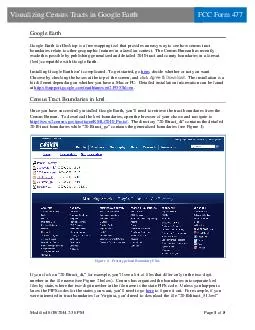
The Census Bureau has recently made this possible by publishing generalized and detailed 2010 tract and county boundaries in a format kml compatible with Google Earth Installing Google Earth isnt complicated To get started go here decide whether or ID: 14390

The Census Bureau has

Share:

Link:

Embed:

Download Presentation from below link

Download Pdf The PPT/PDF document "Modified PM Page of Visualizing Census..." is the property of its rightful owner. Permission is granted to download and print the materials on this web site for personal, non-commercial use only, and to display it on your personal computer provided you do not modify the materials and that you retain all copyright notices contained in the materials. By downloading content from our website, you accept the terms of this agreement.


Presentation Transcript

�� &#x/Att;¬he; [/; ott;&#xom ];&#x/BBo;&#xx [6;.76;4 3;.14;’ 5;a.9; 49;&#x.785; ]/;&#xSubt;&#xype ;&#x/Foo;&#xter ;&#x/Typ; /P; gin; tio;&#xn 00;&#x/Att;¬he; [/; ott;&#xom ];&#x/BBo;&#xx [6;.76;4 3;.14;’ 5;a.9; 49;&#x.785; ]/;&#xSubt;&#xype ;&#x/Foo;&#xter ;&#x/Typ; /P; gin; tio;&#xn 00;Modified 6/18/2014 2:36 PMPage of VisualizingCensus Tractsin Google Earth Google Earth Google Earth for Desktop is free mapping tool that provides an easy ay to see how census tract boundaries relate to other geographic features in a familiar context. The Census Bureau has recently made this possible decide whether or not you want Chrome by checking the boxes at the topof the screen https://support.google.com/earth/answer/21955?hl=en . Once youhave successfully installed Google Earth, you’ll need to retrieve the tract boundaries from the Census Bureau. To download the kml boundaries, open the browser of your choice and navigate to http://www2.census.gov/geo/tiger/KML/2010_Proto/ 2010 tract boundaries while “2010tract_gz” contains the generalized boundaries(see Figure 1) Figure : Prototype kml Boundary FilesIf you click on “ to figure it out. For example, if you were interested in tract boundaries for Virginia, you’d need to download the file “2010dttract_51.kml �� &#x/Att;¬he; [/; ott;&#xom ];&#x/BBo;&#xx [6;.76;4 3;.14;’ 5;a.9; 49;&#x.785; ]/;&#xSubt;&#xype ;&#x/Foo;&#xter ;&#x/Typ; /P; gin; tio;&#xn 00;&#x/Att;¬he; [/; ott;&#xom ];&#x/BBo;&#xx [6;.76;4 3;.14;’ 5;a.9; 49;&#x.785; ]/;&#xSubt;&#xype ;&#x/Foo;&#xter ;&#x/Typ; /P; gin; tio;&#xn 00;Modified 6/18/2014 2:36 PMPage of VisualizingCensus Tractsin Google Earth FCC Form 477since Virginia’s FIPS code is 51. Just right click the file, select Save Link As…and save the file locally. Figure : Census Tract Boundaries in kml Format by State Viewing Census Tract Boundaries in Google Earth At this point, launch Google Earth, click File…Open…navigate to the location of the kml file or files you downloaded from the Census Bureau, select the file, and click Open. Youshould see something like Figure 3 beloFigure Virginia Census Tracts, First Look �� &#x/Att;¬he; [/; ott;&#xom ];&#x/BBo;&#xx [6;.76;4 3;.14;’ 5;a.9; 49;&#x.785; ]/;&#xSubt;&#xype ;&#x/Foo;&#xter ;&#x/Typ; /P; gin; tio;&#xn 00;&#x/Att;¬he; [/; ott;&#xom ];&#x/BBo;&#xx [6;.76;4 3;.14;’ 5;a.9; 49;&#x.785; ]/;&#xSubt;&#xype ;&#x/Foo;&#xter ;&#x/Typ; /P; gin; tio;&#xn 00;Modified 6/18/2014 2:36 PMPage of VisualizingCensus Tractsin Google Earth FCC Form 477While it’s pretty clear that the file downloaded is indeed for Virginia, the tract boundaries areimpossibleto see. This is because the default settings are white tract polygons with white boundaries. Fortunately it’s easy to changthe lookof these polygons. Rightclick the tract boundary file (the file name appears as “tract_51” under Temporary Places in the screen shot above), select Properties, select Style, Colo, then Share Stylehange the Linestryred and a width of 2.0) and the rea (try “Outlined”). Figure : Changing the LookFigure : Virginia Census Tracts, Improved �� &#x/Att;¬he; [/; ott;&#xom ];&#x/BBo;&#xx [6;.76;4 3;.14;’ 5;a.9; 49;&#x.785; ]/;&#xSubt;&#xype ;&#x/Foo;&#xter ;&#x/Typ; /P; gin; tio;&#xn 00;&#x/Att;¬he; [/; ott;&#xom ];&#x/BBo;&#xx [6;.76;4 3;.14;’ 5;a.9; 49;&#x.785; ]/;&#xSubt;&#xype ;&#x/Foo;&#xter ;&#x/Typ; /P; gin; tio;&#xn 00;Modified 6/18/2014 2:36 PMPage of VisualizingCensus Tractsin Google Earth FCC Form 477You can save the changes in the appearance of the tract boundaries by rightclicking “tract_51” under Temporary Places, Save Place As…, then save the file locally as either kml or kmz(kmz is a compressed version of kml, so it requires less storage) Useful Features Zooming in more closely will allow you to see how tract boundaries relate to the area your company serves. Figure 6 below shows how you can zoom in on a particular area and identify a particular tract. Clicking on the tract polygon will bring up a small window that containsThe notuseful name of the polygon (in this case, “kml_65789”)The GEOIDwhich is the complete 11digit census tract code (here, 51087201101 = Virginia FIPS code = 51 + Henrico County = 087 + Tract 2011.01). For more information about tract codes, see More bout Census Tracts . The NAMEwhich is the census tract name (in this case, 2011.01)Figure Census Tract Boundaries in the Richmond, VA AreaWhile not the most efficient tool for geocoding, you can nonetheless use Google Earth todetermine the census tract for an address.Using this approach allows you to see the point on the Earththat Google’s geocoding engine associates with an address. �� &#x/Att;¬he; [/; ott;&#xom ];&#x/BBo;&#xx [6;.76;4 3;.14;’ 5;a.9; 49;&#x.785; ]/;&#xSubt;&#xype ;&#x/Foo;&#xter ;&#x/Typ; /P; gin; tio;&#xn 00;&#x/Att;¬he; [/; ott;&#xom ];&#x/BBo;&#xx [6;.76;4 3;.14;’ 5;a.9; 49;&#x.785; ]/;&#xSubt;&#xype ;&#x/Foo;&#xter ;&#x/Typ; /P; gin; tio;&#xn 00;Modified 6/18/2014 2:36 PMPage of VisualizingCensus Tractsin Google Earth FCC Form 477Enter an address into the Search field at the upper left of the screen then click Search. After you’rezoomto the location, you can click the polygon that contains the address to show the census tract. Figure 7 shows a search I did for 1300 E. Main St., Richmond, Virginia 23219 (the address of the Virginia State Corporation Commission)Clicking on the tract polygon revealed that it’s located in tract 51760030500.