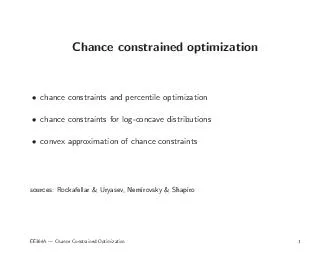
/
Top-Down Constraints on Emissions: Opportunities and Challe Top-Down Constraints on Emissions: Opportunities and Challe

Top-Down Constraints on Emissions: Opportunities and Challe - PowerPoint Presentation

cheryl-pisano
cheryl-pisano . @cheryl-pisano
Follow
448 views
Uploaded On 2016-08-10

Top-Down Constraints on Emissions: Opportunities and Challe - PPT Presentation

Randall Martin with contributions from Shailesh Kharol Gray OByrne Akhila Padmanabhan Aaron van Donkelaar 2013 China Emissions Workshop Beijing 28 June 2013 Lok ID: 440962

nox emissions satellite so2 emissions nox so2 satellite retrievals omi error observations no2 top 2006 2010 pm2 slope tropospheric

Share:

Link:

Embed:

Download Presentation from below link

Download Presentation The PPT/PDF document "Top-Down Constraints on Emissions: Oppor..." is the property of its rightful owner. Permission is granted to download and print the materials on this web site for personal, non-commercial use only, and to display it on your personal computer provided you do not modify the materials and that you retain all copyright notices contained in the materials. By downloading content from our website, you accept the terms of this agreement.


Presentation Transcript

Slide1

Top-Down Constraints on Emissions: Opportunities and Challenges from Satellite Observations of Atmospheric Composition

Randall Martinwith contributions fromShailesh Kharol, Gray O’Byrne, Akhila Padmanabhan, Aaron van Donkelaar

2013 China Emissions Workshop, Beijing28 June 2013

Lok

Lamsal

(Dalhousie

NASA),

Chulkyu

Lee (Dalhousie

 K

MA

)

Jintai

Lin (PKU

),

Daven

Henze

(CU Boulder),

Guannan

Geng

,

Qiang

Zhang, and

Yuxuan

Wang (Tsinghua)Slide2

Satellite-derived PM2.5 for 2001-2006

van Donkelaar et al., EHP, 2010Evaluation in

North America:r=0.77slope = 1.07N=1057Outside Canada/USN = 244 (84 non-EU)r = 0.83 (0.83)Slope = 0.86 (0.91)Bias = 1.15 (-2.64) μg/m3Slide3

PM2.5 Nearly as Sensitive to Emissions of NOx as to SO2

Kharol et al., GRL, 2013

GEOS-

Chem Calculation of Annual PM2.5 Response to 10% Change in Emissions

Δ

NO

x

Emissions

Δ

SO

2

Emissions

Δ

NH

3

Emissions

25%

41%

34%

Δ

PM

2.5 (ug m-3)

-0.5 0 1 2

But How Accurate are the Emissions Used in this Calculation?

How Accurate are Emissions in General?

What Can We Learn about Emissions from Satellite Observations? Slide4

Major Nadir-viewing Space-based Measurements of Tropospheric Trace Gases and Aerosols (Not Exhaustive)

SensorMOPITT

MISRMODIS

AIRS

SCIA-MACHY

TES

OMI

CALIOP

GOME-2

IASI

GOSAT

VIIRS

TROP-OMI

Platform (launch)

Terra Aqua

(1999) ( 2002)

Envisat (2002)

Aura

(2004)

Calipso

(2006)

MetOp

(2006)

IBUKI (2009)

NPP (2011)

Sent-5 Precur (2014)Typical Res (km)22x2218x1810x1014 x1460x308x5>24x1340x4080x4012 x1211x116x67x7AerosolXXXXXXXXNO2XXXXHCHOXXXXCOXXXXXXXOzoneXXXXXXSO2XXXXXNH3XXCH4XXXXXCO2XXXX

Solar Backscatter

&

Thermal InfraredSlide5

Close Relationship of NOx and SO2 Emissions With Satellite Tropospheric NO2

and SO2 ColumnsEmission

NO

NO

2

HNO

3

lifetime hours

Nitrogen Oxides (NO

x

)

Sulfur Dioxide (SO

2

)

Emission

SO

2

OH, cloud

SO

42-day

BOUNDARY

LAYER

Satellite

NO

/

NO2   W ALTITUDETropospheric NO2 column ~ ENOxTropospheric SO2 column ~ ESO2 DepositionSlide6

Top-Down

(Mass Balance) Estimates of

NOx & SO2 Emissions

SCIAMACHY Tropospheric NO

2

(10

15

molec cm

-2

)

NO

x

emissions (10

11

atoms N cm-2 s-1)

Lee et al., 2011

2004-2005

SO

2 emissions (1011 atoms N cm-2 s-1)OMI SO2 (1016

molec cm-2)200649.9 Tg S yr-1

Martin et al., 2006 Slide7

Lamsal

et al., GRL, 2011Streets et al., AE, in pressApplication of Satellite Observations for Timely Updates to NOx Emission Inventories

Use GEOS-Chem to Calculate Local Sensitivity of Changes in Trace Gas Column to Changes in Emissions

Forecast Inventory for 2010 Based on Bottom-up for 2005 and Monthly OMI NO

2

for 2005-2010

2.5%

increase in global emissions

27%

increase in Asian emissions

23%

decrease in North American emissionsSlide8

Integration of Top-down Information In Bottom-up ApproachExample Evaluation of Spatial Proxies

Guannan Geng (Tsinghua) et al. in prepPopulation

, Outdated Road NetworkIndustrial GDP, New Road NetworkSlide9

ComplicationsSatellite Retrievals

Inverse Modeling Slide10

Need to Account for Average Kernel in IR Satellite RetrievalsIASI Provides Some Constraint on NH3

EmissionsKharol et al., GRL, 2013

Using NH

3

emissions

from

Streets et

al. (2003) reduced

by

30% following Huang et al. (2012)

with Averaging Kernels

Total ColumnSlide11

Need to Account for Vertical Profile and Atmospheric Scattering (Air Mass Factor; AMF)

in UV-Vis Retrievals dt()

Io

I

B

EARTH SURFACE

Radiative Transfer Model

Scattering weight

Atmospheric Chemistry Model

“a-priori” Shape factor

Calculate

w

(

) as function of:

solar and viewing zenith angle

surface albedo, pressure

cloud pressure, aerosol

OMI O

3 column

INDIVIDUAL

OMI SCENES

SO

2 mixing ratio CSO2()() is temperature dependent cross-sectionsigma ()Slide12

Local Air Mass Factor and Offset Correction Improves Agreement with Aircraft Observations (INTEX-A and B)

Lee et al., JGR, 2009SCIAMACHYOMI

Orig: slope = 1.3, r=0.78 New: slope = 1.1, r=0.89Orig: slope = 1.6, r = 0.71 New: slope = 0.95, r = 0.92

SCIAMACHYOMISlide13

Need to Account for Multiple Effects of Aerosols on UV-Vis Trace Gas Retrievals

Accounting for Aerosol Haze Can Increase R2 (0.720.96) of OMI NO2 vs Ground-based DOAS Observations in China Jintai Lin (PKU) et al., in prep, ACPSlide14

Expected OMI NO2 Retrieval Bias for Snow-Covered ScenesDue to Errors in Accounting for Transient Snow & Ice

O’Byrne et al., JGR, 2010

With Cloud

Fraction

Threshold (f < 0.3)

-0.5

0

1.0

All

Cloud

Fractions

0.5Slide15

Aerosol Retrievals Susceptible to Bias over Bright SurfacesAerosol Optical Depth (AOD) from MODIS and MISR over 2001-2006

MODIS1-2 days for global coverage (w/o clouds)AOD retrievals at 10 km x 10 kmRequires assumptions about surface reflectivityMISR6-9 days for global coverage (w/o clouds)AOD retrievals at 18 km x 18 kmSimultaneous retrieval of surface reflectance and aerosol optical properties

0 0.1 0.2 0.3AOD [unitless]van Donkelaar et al., EHP, 2010Slide16

Can Remove Biased Data Using Sunphotometer Observations Excluded Retrievals

for Land Types with Monthly Error vs AERONET >0.1 or 20%

MODIS

r = 0.39

(vs. in-situ PM

2.5

)

MISR

r = 0.39

(vs. in-situ PM

2.5

)

Combined

MODIS/MISR

r = 0.61

(vs. in-situ PM

2.5)

0.30.250.20.15

0.10.050

AOD [unitless]

van Donkelaar et al., EHP, 2010Slide17

Δ

Adjoint Reduces Inversion Error vs Mass BalanceTest to Recover 30% Increased NOx Emissions in Four Locations Using a Week of Synthetic Observations of NO2 ColumnsNovember JulyMass BalanceAdjoint

Inversion – Truth (ΔNOx Emissions molec cm-2 s-1)

Padmanabhan et al., in prep

NME=3x10

-3

NME=6x10

-3

NME=4x10

-4

NME=5x10

-4

NME = Normalized Mean ErrorSlide18

How Well Do Models Represent SO2 Lifetime in China?Evaluation of GEOS-Chem SO

2 Lifetime vs Calculations from In Situ Measurements in Eastern US

U Maryland Research Flights for Eastern U.S.

Hains, Dickerson, et al., 2007

June - August

C is SO

2

from EPA Network H is GEOS Mixed Layer Depth

Lee et al., JGR,

2011Slide19

Inversion Relies on Relative Error in Bottom-up and Top-down Approaches: Embrace UncertaintyNeed information on uncertainty (σ)

Observed Trace Gas

a priori emissionsa posteriori

emissions

a

priori

error

observational error

Inverse problem seeks emissions

E

that minimize cost function

J

Error

weighting

A posteriori emissions

E

A Priori

NOx

Emissions

(Ea)

Observed NO2 Columns (Ω)

Model F(E)σ

σ

aSlide20

Uncertainty in SO2 Retrievals Due to Clouds, Surface Reflectance, SO2 Vertical Profile, and Aerosols

Lee et al., JGR, 2009

Cloud-free Fraction of Scene

Cloudy Fraction of SceneSlide21

Most Satellites Observe at Specific Times of DayRequires Attention to the Diurnal Profile of EmissionsSlide22

ConclusionsSubstantial opportunities and challengesIntegrate

top-down and bottom-up methods & communitiesAccount for retrieval assumptions in inversion (e.g. trace gas profile)Avoid bias (e.g. aerosol, snow) in satellite data products and algorithms Quantify uncertainty in both top-down and bottom-up methodsAcknowledgements:NSERC, Environment Canada