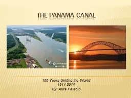
100 Years Uniting the World 19142014 By Aura Palacio Where is Panama is located in Central America bordering both the Caribbean Sea and the North Pacific Ocean between Colombia and Costa Rica ID: 530071
Download Presentation The PPT/PDF document "THE PANAMA CANAL" is the property of its rightful owner. Permission is granted to download and print the materials on this web site for personal, non-commercial use only, and to display it on your personal computer provided you do not modify the materials and that you retain all copyright notices contained in the materials. By downloading content from our website, you accept the terms of this agreement.
Slide1
THE PANAMA CANAL
100 Years Uniting the World1914-2014By: Aura PalacioSlide2
Where is Panama?
is located in Central America, bordering both the Caribbean Sea and the North Pacific Ocean, between Colombia and Costa RicaSlide3
The French failure
In 1880, the French attempted to construct a waterway pass across the Isthmus but failed mainly because the very sick and dead among the French employees on the Isthmus.Slide4
Colombia rejected United States plans to build a canal across the Isthmus of Panama leading later a revolution where Panama became a Republic in 1903.Slide5
It is estimated that over 80,000 persons took part in the construction and that over 30,000 lives were lost in both French and American
efforts.
U.S President Theodore Roosevelt
Visiting the canal construction site.Slide6
The Panama canal 1904-1914
The building of the Panama Canal took 34 years from the initial effort in 1880 to actually opening the canal in 1914. The building of the canal is considered one of the greatest engineering triumphs in history.Slide7
Why build THE Canal?
Initially, for military purposesSave moneyTransport goods fasterQuick access to the Atlantic and Pacific oceans Slide8
Why build THE Canal?
Traveling from Atlantic to Pacific, ships navigated around Cape Horn, the treacherous southern extremity of South America. A New York to San Francisco journey measured some 13,000 miles and took months.Slide9
How it works…..Slide10
How it works…..
It is a three sets lock systemLifts a ship up 85 feet to the ocean and down againIt has a total of six steps (three up, three down)The total length of the lock structure, is over 1.9 milesSlide11
How it works…..
There are two independent transit lanes (each lock is built double)Double lanes allows ships to pass in opposite directions at the same time (large ships pass in one direction only)Each lock chamber requires 26,700,000 US gal of water to fill it from the lowered to the raised position. The same amount of water must be drained againWater is moved by gravity and is controlled by big valves
Chamber can be filled in eight minutesSlide12
How it works…..
The gates of the lakes are doubled for safety.Ships are guided by electric locomotives as an important safety featureSlide13
The panama canal in operation
http://www.bing.com/videos/search?q=panama%20canal%20&FORM=BVLH1#view=detail&mid=5AE0FB63473FC7EEA69D5AE0FB63473FC7EEA69DSlide14
The Expansion….
The Panama Canal expansion project (also called the Third Set of Locks Project) will double the capacity of the Panama Canal by 2015 by creating a new lane of traffic and allowing more and larger ships to transit.The project will:Build two new locks, one each on the Atlantic and Pacific sides. Each will have three chambers with water-saving basins.Excavate new channels to the new locks.Widen and deepen existing channels.
Raise the maximum operating level of Gatun Lake.[1]
(
http://en.wikipedia.org/wiki/Panama_Canal_expansion_project)Slide15
References
http://www.binal.ac.pa/binal/http://www.history.com/videos/panama-canal-lockshttp://es.wikipedia.org/wiki/Canal_de_Panam%C3%A1http://micanaldepanama.com/educadores/preguntas-frecuentes/http://www.slideshare.net/guest03ed30/unit-6-panama-canal-great-powerpointSlide16
Muchas
gracias
por
su
atención
…..
http://www.bing.com/videos/search?q=musica+folklorica+panamena&FORM=VIRE3&adlt=strict#view=detail&mid=AB4707652BC20ABF922BAB4707652BC20ABF922BSlide17
Activity - Passing by the panama canal
Objective(s):Learn how to plan a vacation to the Panama CanalKnow the geography of the Caribbean IslandsKnow the history of the Panama CanalMaterials:White paper (passports)StaplerGlueStampFlags (countries to be visited)
Decals or stamps Color paper to labelPanama canal map (please enlarge for a better view)Caribbean map (enlarge for a better view)Slide18
Passing by the panama canal…
Methodology:Students create a ship(identify the ship with a flag) and a passport for their imaginary trip (student must be creative)After presenting students the facts about the Panama Canal operation and the geography of the Caribbean Islands, students are ready for the imaginary trip. Use the Panama Canal map to guide them to the Cuenca (Chagres river, Gatun, Alajuela lake, and explain them that it is the main water supplier for the city as well as the water used to operate the canal. Let students use their ship and stop there.Now point to the locks and explain them that each ship has to cross the Gatun lock, the Miraflores lock and the Pedro Miguel in about 8-10 hours. Allow the students to move to the locks with their ship.Students are ready to view different ships that cross the canal every day. Students take turn to place their ship from different countries on the map.
Let students share their experience/write a reflectionSlide19
Passing by the panama canal continuing…..
Basic Information (Refer to these websites)http://history.state.gov/milestones/1899-1913/panama-canalhttp://geography.about.com/od/specificplacesofinterest/a/panamacanal.htmhttp://www.pbs.org/wgbh/americanexperience/features/general-article/tr-panama/
http://filebox.vt.edu/users/kbartell/Lesson%20Plan%20Panama%20Canal.pdf Slide20
Map of the panama canalSlide21
Passing by the panama canal continuing………….