/
The Pulse of UCF James Doty The Pulse of UCF James Doty

The Pulse of UCF James Doty - PowerPoint Presentation

danika-pritchard
danika-pritchard . @danika-pritchard
Follow
355 views
Uploaded On 2018-12-05

The Pulse of UCF James Doty - PPT Presentation

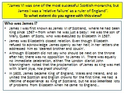
EEL 6788 University of Central Florida 19 April 2010 Introduction The primary goal of the Pulse of UCF project was to create a mobile application that would help find certain locations on campus ID: 736050

iphone data view app data iphone app view server location find grid web minimal google map noise locations 30m

Share:

Link:

Embed:

Download Presentation from below link

Download Presentation The PPT/PDF document "The Pulse of UCF James Doty" is the property of its rightful owner. Permission is granted to download and print the materials on this web site for personal, non-commercial use only, and to display it on your personal computer provided you do not modify the materials and that you retain all copyright notices contained in the materials. By downloading content from our website, you accept the terms of this agreement.


Presentation Transcript

Slide1

The Pulse of UCF

James Doty

EEL 6788

University of Central Florida

19 April 2010Slide2

Introduction

The primary goal of the Pulse of UCF project was to create a mobile application that would help find certain locations on campus:

Busiest

Most exciting

Most popular place to study

It was designed for the

iPhoneSlide3

Requirements

Capture data from an

iPhone

app:

Latitude

Longitude

Noise level (% maximum)

Time of Day

Device ID

Log data to a server wirelesslySlide4

Requirements

Provide a website that would allow a user to find the three locations previously mentioned

Provide the same data through the

iPhone

application

Provide a map view of the data collectedSlide5

Design – High Level

Raw Data

Analyzed

LocationsSlide6

iPhone App

Designed on a custom PC running OSX Leopard (10.5.7)

Xcode

3.1.4

Needed an x86 processor, so couldn’t just use the iMac G4

iPhone

OS 3.1.3

iPhone

3GS on AT&T

Written in Objective-CSlide7

iPhone App Block Diagram

AppDelegate

View Controller

SCListener

Location Service

CoreLocation

APISlide8

iPhone App Description

CoreLocation

API provides location only on move event

Must register a callback

Location Service class handles this

View Controller (main GUI class) has a timer that “ticks” every 5 seconds

Each tick, the current location is pulled from the Location Service and the noise is pulled from the

SCListener

class

Sent out with HTTP POST

GUI elements are updatedSlide9

Web Server

iMac G4

Apache

MySQL

Since OSX is a

unix

variant, minimal work needed to get server up and running

Programming done in PythonSlide10

Web Server Block Diagram

p

ostdata.py

MySQL

DB

index.html

getpulse.py

exciting.py

busiest.py

study.pySlide11

Database Tables

d

ata

id integer unique primary key

udid

char(40)

l

atitude double

longitude double

noise double

t

od timeTOD calculated on the server side with now() function

campusgrid unique primary keylatmax double

latmin doublelonmax doublelonmin doubleDivides campus into a grid of plots about 30m x 30mSlide12

Functionality

Displays data from sensors

Indicates server status

Allows the user to temporarily stop sending data to the server

Displays a web view of the data analysis siteSlide13

Web ViewSlide14

Data MapSlide15

Data Map

Generated as a KML (Google Earth XML) file

Can be viewed in Google Earth or Google Maps

Google Earth view updates every 5 seconds to show a live view of data being gathered

Each point is clickable to show the measured noise levelSlide16

Challenges – Objective C

Difficult language to learn, especially coming from a C++/C# background

I’ve never used Smalltalk before

The syntax was odd

iPhone

development requires an Intel Mac, so my old PPC iMac wouldn’t cut it

Had to get OSX to install on a non-Apple PC

AMD processor made things more difficult

Apple kernel built only for IntelSlide17

Challenges - Databases

Gathering data and storing it was simple

Interpreting it was a challenge

My SQL experience didn’t extend far beyond simple queries and table joins

As a result, most actual data processing was done in the Python CGI scripts

Had to determine a simple way to group points by location fast enough to process in real-timeSlide18

Technical Limitations

30m by 30m grids are fixed

Small grid would increase processing time, potentially miss big spread out groups

Larger grid would have the opposite problem

iPhone

GPS is not 100% accurate

iPhone

microphone levels vary widely based on how the phone is carried

App must be running to gather data

Shortens battery life

No privacy or security implemented

Each device UDID is recorded – identity can be determined based on locations visitedSlide19

Future Work

Make grid worldwide, not just UCF

Display color-coded grid map rather than just individual points

Anonymize

device UDID

Improve UI

Allow time filtering on searches

Find most crowded place right now

Find most crowded place on a typical Saturday night

Find

lonliest

/least crowded placesChallenging because low crowds mean minimal dataSlide20

Commercialization

Since it depends entirely on voluntary user data collection, the app would most likely have to be free

Any business plan would either be based on selling advertisements in-program or selling the collected data to other data-mining companies

Without at least a minimal number of users, the app is useless

Would need some sort of advertising blitz to get people interested

Maybe pay students a minimal amount of money to gather initial dataSlide21

Demo