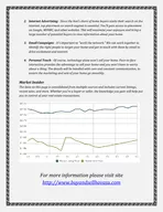
PPT-Examining Lake Michigan Spring
Author : debby-jeon | Published Date : 2016-05-20
Euphotic Depth Z eu Anomalies u tilizing 10 years of MODISAqua data a t 4 kilometer resolution James G Acker NASA GES DISC Wyle IS LLC 2012 Gregory G Leptoukh
Presentation Embed Code
Download Presentation
Download Presentation The PPT/PDF document "Examining Lake Michigan Spring" is the property of its rightful owner. Permission is granted to download and print the materials on this website for personal, non-commercial use only, and to display it on your personal computer provided you do not modify the materials and that you retain all copyright notices contained in the materials. By downloading content from our website, you accept the terms of this agreement.
Examining Lake Michigan Spring: Transcript
Euphotic Depth Z eu Anomalies u tilizing 10 years of MODISAqua data a t 4 kilometer resolution James G Acker NASA GES DISC Wyle IS LLC 2012 Gregory G Leptoukh Online Giovanni Workshop. Reproduction without permission is strictly prohibited Visit transitchicagocommaps for latest version Lake Michigan. Nearshore. . Monitoring. John Hummer and Guan Wang. Great Lakes Commission. Summer Webinar. July 24, 2013. Recognized as necessary component of the Great Lakes ecosystem. What is the “. Danielle . Tarpley. , Courtney K. Harris, Carl T. . Friedrichs. Virginia Institute of Marine Science. Rinehimer. , 2008. ETM. STM. Gloucester Point. Scully and . Friedrichs. , 2007. Motivation: Sediment availability impacts sediment distribution. Grant E. Gunn. 1. , Claude R. . Duguay. 2. , Don Atwood. 3. 1. Department of Geography, Environment and Spatial Sciences, Michigan State University, 673 Auditorium Road, East Lansing, Michigan, 48825, United States. Jay Wesley. Lake Michigan Basin Coordinator. https://. www.youtube.com/watch?v=wLiG4wwYM6M. Balanced Food Pyramid. 1950’s-1982 Unbalanced. 1982 -1990 Unbalanced. 1990-2002 Balanced. 2003-2016 Sometimes Balanced And Changing. Image:. Michigan. Historical. Museum. How did the Great Lakes form?. 15,000 years ago, the . Laurentide. Ice Sheet . covered all of Michigan (maximum extent was 18,000 years ago). Lake Michigan Lobe. Jay Wesley. Lake Michigan Basin Coordinator. https://www.youtube.com/watch?v=wLiG4wwYM6M. Balanced Food Pyramid. 1950’s-1982 Unbalanced. 1982 -1990 Unbalanced. 1990-2002 Balanced. 2003-2017 Sometimes Balanced And Changing. Salmon in Indiana Your purchase of fishing equipment and motor boat fuel supports boating access and Sport Fish Restoration. Indiana Fishing Regulation Gu Channel Drive Swimming Lagoon Jack RabbitMeadows Upper Oak Knolls Spring Lake Newanga AveVioletti RdSullivan Ridge TrailKerfoot Trail Upper GroupPicnic AreaLower Group Bay Area Ridge Trail Fishermans 2 1917 Indiana does her part, and more than her part, in General Meetings The following general meetings have been arranged Beechwood Academy Students' Aid Fund One of the first men to donate money fo Salmon in Indiana Your purchase of fishing equipment and motor boat fuel supports boating access and Sport Fish Restoration. Indiana Fishing Regulation Gu WaubunMASE AREA B MASA Region 7BarnumCarlton ChisholmCloquet Cook County Cromwell Deer River Duluth Ely Esko Eveleth-Gilbert Floodwood Grand Rapids Hermantown Hibbing Hill City International Falls Lak popopopopopopopopopopopopopopopopopopopopopopopopopopopopopopopopopopopopopopopopopopopopopopopopo312726252073363394041737450484253615257563083536373865516677677168767978298184838232854512601418Monito vices Eat Safe Fish Eat Safe Fish Guide Guide Some sh contain chemicals that can harm your health. MDHHS tests lets of sh taken from Michigan’s lakes an
Download Document
Here is the link to download the presentation.
"Examining Lake Michigan Spring"The content belongs to its owner. You may download and print it for personal use, without modification, and keep all copyright notices. By downloading, you agree to these terms.
Related Documents