/
ILLINOISKENTUCKYKENTUCKYILLINOISILLINOISKENTUCKYTENNESSEE ILLINOISKENTUCKYKENTUCKYILLINOISILLINOISKENTUCKYTENNESSEE

ILLINOISKENTUCKYKENTUCKYILLINOISILLINOISKENTUCKYTENNESSEE - PDF document

debby-jeon
debby-jeon . @debby-jeon
Follow
367 views
Uploaded On 2016-02-29

ILLINOISKENTUCKYKENTUCKYILLINOISILLINOISKENTUCKYTENNESSEE - PPT Presentation

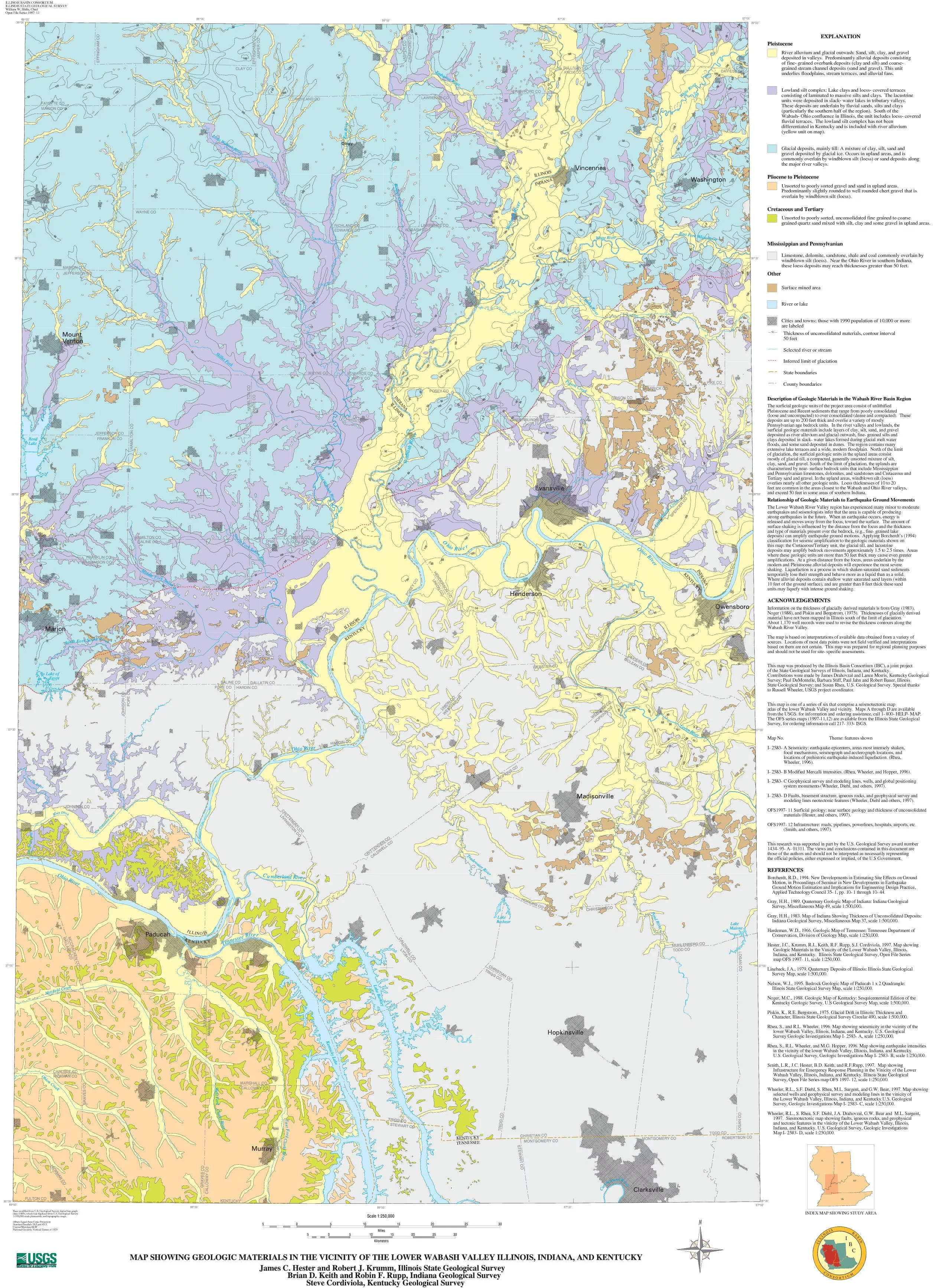
River alluvium and glacial outwash Sand silt clay and graveldeposited in valleys Predominantly alluvial deposits consistingof fine grained overbank deposits clay and silt and coarsegrained s ID: 235883

River alluvium and glacial outwash:

Share:

Link:

Embed:

Download Presentation from below link

Download Pdf The PPT/PDF document "ILLINOISKENTUCKYKENTUCKYILLINOISILLINOIS..." is the property of its rightful owner. Permission is granted to download and print the materials on this web site for personal, non-commercial use only, and to display it on your personal computer provided you do not modify the materials and that you retain all copyright notices contained in the materials. By downloading content from our website, you accept the terms of this agreement.


Presentation Transcript

ILLINOISKENTUCKYKENTUCKYILLINOISILLINOISKENTUCKYTENNESSEE River alluvium and glacial outwash: Sand, silt, clay, and graveldeposited in valleys. Predominantly alluvial deposits consistingof fine- grained overbank deposits (clay and silt) and coarse-grained stream channel deposits (sand and gravel). This unitunderlies floodplains, stream terraces, and alluvial fans. Lowland silt complex: Lake clays and loess- covered terracesconsisting of laminated to massive silts and clays. The lacustrineunits were deposited in slack- water lakes in tributary valleys.These deposits are underlain by fluvial sands, silts and clays(particularly the southern half of the region). South of theWabash- Ohio confluence in Illinois, the unit includes loess- coveredfluvial terraces. The lowland silt complex has not beendifferentiated in Kentucky and is included with river alluvium(yellow unit on map). Glacial deposits, mainly till: A mixture of clay, silt, sand andgravel deposited by glacial ice. Occurs in upland areas, and iscommonly overlain by windblown silt (loess) or sand deposits alongthe major river valleys. Unsorted to poorly sorted gravel and sand in upland areas.Predominantly slightly rounded to well rounded chert gravel that isoverlain by windblown silt (loess). Unsorted to poorly sorted, unconsolidated fine grained to coarsegrained quartz sand mixed with silt, clay and some gravel in upland areas. Limestone, dolomite, sandstone, shale and coal commonly overlain bywindblown silt (loess). Near the Ohio River in southern Indiana,these loess deposits may reach thicknesses greater than 50 feet. Surface mined area River or lake Cities and towns; those with 1990 population of 10,000 or moreare labeled Thickness of unconsolidated materials, contour interval50 feet Selected river or stream Inferred limit of glaciation State boundaries County boundariesThe surficial geologic units of the project area consist of unlithifiedPleistocene and Recent sediments that range from poorly consolidated(loose and uncompacted) to over consolidated (dense and compacted). Thesedeposits are up to 200 feet thick and overlie a variety of mostlyPennsylvanian age bedrock units. In the river valleys and lowlands, thesurficial geologic materials include layers of clay, silt, sand, and graveldeposited as river alluvium and glacial outwash, fine- grained silts andclays deposited in slack- water lakes formed during glacial melt waterfloods, and some sand deposited in dunes. The region contains manyextensive lake terraces and a wide, modern floodplain. North of the limitof glaciation, the surficial geologic units in the upland areas consistmostly of glacial till, a compacted, generally unsorted mixture of silt,clay, sand, and gravel. South of the limit of glaciation, the uplands arecharacterized by near- surface bedrock units that include Mississippianand Pennsylvanian limestones, dolomites, and sandstones and Cretaceous andTertiary sand and gravel. In the upland areas, windblown silt (loess)overlies nearly all other geologic units. Loess thicknesses of 10 to 20feet are common in the areas closest to the Wabash and Ohio River valleys,and exceed 50 feet in some areas of southern Indiana.The Lower Wabash River Valley region has experienced many minor to moderateearthquakes and seismologists infer that the area is capable of producingstrong earthquakes in the future. When an earthquake occurs, energy isreleased and moves away from the focus, toward the surface. The amount ofsurface shaking is influenced by the distance from the focus and the thicknessand type of materials present over the bedrock, (e.g., fine- grained lakedeposits) can amplify earthquake ground motions. Applying Borcherdt’s (1994)classification for seismic amplification to the geologic materials shown onthis map: the Cretaceous/Tertiary unit, the glacial till, and lacustrinedeposits may amplify bedrock movements approximately 1.5 to 2.5 times. Areaswhere these geologic units are more than 50 feet thick may cause even greateramplifications. At a given distance from the focus, areas underlain by themodern and Pleistocene alluvial deposits will experience the most severeshaking. Liquefaction is a process in which shaken saturated sand sedimentstemporarily lose their strength and behave more as a liquid than as a solid.Where alluvial deposits contain shallow water saturated sand layers (within10 feet of the ground surface), and are greater than 8 feet thick these sandunits may liquefy with intense ground shaking.Information on the thickness of glacially derived materials is from Gray (1983),Noger (1988), and Piskin and Bergstrom, (1975). Thicknesses of glacially derivedmaterial have not been mapped in Illinois south of the limit of glaciation.About 1,170 well records were used to revise the thickness contours along theThe map is based on interpretations of available data obtained from a variety ofsources. Locations of most data points were not field verified and interpretationsbased on them are not certain. This map was prepared for regional planning purposesand should not be used for site- specific assessments.This map was produced by the Illinois Basin Consortium (IBC), a joint projectof the State Geological Surveys of Illinois, Indiana, and Kentucky.Contributions were made by James Drahovzal and Lance Morris, Kentucky GeologicalSurvey; Paul DuMontelle, Barbara Stiff, Paul Jahn and Robert Bauer, IllinoisState Geological Survey; and Susan Rhea, U.S. Geological Survey. Special thanksto Russell Wheeler, USGS project coordinator.This map is one of a series of six that comprise a seismotectonic mapatlas of the lower Wabash Valley and vicinity. Maps A through D are availablefrom the USGS. for information and ordering assistance, call 1- 800- HELP- MAP.The OFS series maps (1997-11,12) are available from the Illinois State GeologicalSurvey, for ordering information call 217- 333- ISGS.Map No. Theme: features shownI- 2583- A Seismicity: earthquake epicenters, areas most intensely shaken, focal mechanisms, seismograph and acclerograph locations, and locations of prehistoric earthquake-induced liquefaction. (Rhea, Wheeler, 1996).I- 2583- B Modified Mercalli intensities. (Rhea, Wheeler, and Hopper, 1996).I- 2583- C Geophysical survey and modeling lines, wells, and global positioning system monuments (Wheeler, Diehl, and others, 1997).I- 2583- D Faults, basement structure, igneous rocks, and geophysical survey and modeling lines neotectonic features (Wheeler, Diehl and others, 1997).OFS1997- 11 Surficial geology: near surface geology and thickness of unconsolidated materials (Hester, and others, 1997).OFS1997- 12 Infrastructure: roads, pipelines, powerlines, hospitals, airports, etc. (Smith, and others, 1997).This research was supported in part by the U.S. Geological Survey award number1434- 95- A- 01311. The views and conclusions contained in this document arethose of the authors and should not be interpreted as necessarily representingthe official policies, either expressed or implied, of the U.S Government.Borcherdt, R.D., 1994. New Developments in Estimating Site Effects on Ground Motion, in Proceedings of Seminar in New Developments in Earthquake Ground Motion Estimation and Implications for Engineering Design Practice, Applied Technology Council 35- 1, pp. 10- 1 through 10- 44.Gray, H.H., 1989. Quaternary Geologic Map of Indiana: Indiana Geological Survey, Miscellaneous Map 49, scale 1:500,000.Gray, H.H., 1983. Map of Indiana Showing Thickness of Unconsolidated Deposits: Indiana Geological Survey, Miscellaneous Map 37, scale 1:500,000.Hardeman, W.D., 1966. Geologic Map of Tennessee: Tennessee Department of Conservation, Division of Geology Map, scale 1:250,000.Hester, J.C., Krumm, R.J., Keith, R.F. Rupp, S.J. Cordiviola, 1997. Map showing Geologic Materials in the Vinicity of the Lower Wabash Valley, Illinois, Indiana, and Kentucky. Illinois State Geological Survey, Open File Series map OFS 1997- 11, scale 1:250,000.Lineback, J.A., 1979. Quaternary Deposits of Illinois: Illinois State Geological Survey Map, scale 1:500,000.Nelson, W.J., 1995. Bedrock Geologic Map of Paducah 1 x 2 Quadrangle: Illinois State Geological Survey Map, scale 1:250,000.Noger, M.C., 1988. Geologic Map of Kentucky: Sesquicentennial Edition of the Kentucky Geologic Survey, U.S Geological Survey Map, scale 1:500,000.Piskin, K., R.E. Bergstrom, 1975. Glacial Drift in Illinois: Thickness and Character, Illinois State Geological Survey Circular 490, scale 1:500,000.Rhea, S., and R.L. Wheeler, 1996. Map showing seiesmicity in the vicinity of the lower Wabash Valley, Illinois, Indiana, and Kentucky. U.S. Geological Survey Geologic Investigations Map I- 2583- A, scale 1:250,000.Rhea, S., R.L. Wheeler, and M.G. Hopper, 1996. Map showing earthquake intensities in the vicinity of the lower Wabash Valley, Illinois, Indiana, and Kentucky. U.S. Geological Survey, Geologic Investigations Map I- 2583- B, scale 1:250,000.Smith, L.R., J.C. Hester, B.D. Keith, and R.F.Rupp, 1997. Map showing Infrastructure for Emergency Response Planning in the Vinicity of the Lower Wabash Valley, Illinois, Indiana, and Kentucky. Illinois State Geological Survey, Open File Series map OFS 1997- 12, scale 1:250,000.Wheeler, R.L., S.F. Diehl, S. Rhea, M.L. Sargent, and G.W. Bear, 1997. Map showing selected wells and geophysical survey and modeling lines in the vinicity of the Lower Wabash Valley, Illinois, Indiana, and Kentucky.U.S. Geological Survey, Geologic Investigations Map I- 2583- C, scale 1:250,000.Wheeler, R.L., S. Rhea, S.F. Diehl, J.A. Drahovzal, G.W. Bear and M.L. Sargent, 1997. Siesmotectonic map showing faults, igneous rocks, and geophysical and tectonic features in the vinicity of the Lower Wabash Valley, Illinois, Indiana, and Kentucky. U.S. Geological Survey, Geologic Investigations Map I- 2583- D, scale 1:250,000. 50 Base modified from U.S. Geological Survey digital line graphdata (1989), which was digitized from U.S. Geological Survey1:100,000-scale planimetric and topographic maps.Albers Equal-Area Conic ProjectionStandard Parallels 29.5 and 45.5Central Meridian 88 WNational Geodetic Vertical Datum of 1929ILLINOIS BASIN CONSORTIUMILLINOIS STATE GEOLOGICAL SURVEYWilliam W. Shilts, ChiefOpen File Series 1997- 11 INDEX MAP SHOWING STUDY AREA ICBILLINOISCONSORTIUMBASIN

Related Contents


Next Show more