/
Mineral Block Mineral Block

Mineral Block - PDF document

dorothy
dorothy . @dorothy
Follow
342 views
Uploaded On 2021-09-15

Mineral Block - PPT Presentation

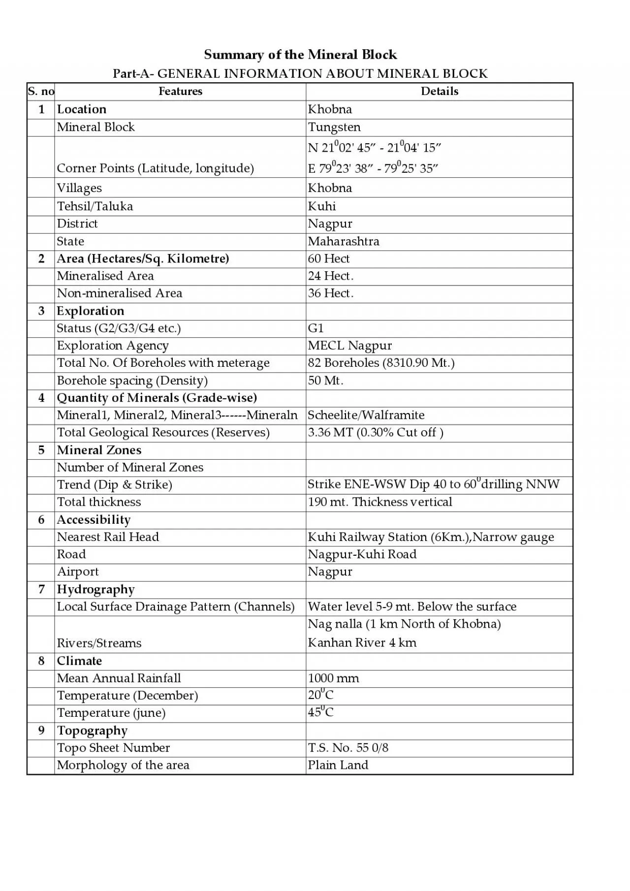
S noFeaturesDetails1LocationKhobnaTungstenCorner Points Latitude longitudeN 21002x0027 45 21004x0027 15 E 79023x0027 38 7925x0027 35VillagesKhobnaTehsilTalukaKuhiDistrictNagpurStateMaharashtra2Ar ID: 881856

area hect status mineral hect area mineral status land x0027 total nagpur clearances consent line khobna particulars state block

Share:

Link:

Embed:

Download Presentation from below link

Download Pdf The PPT/PDF document "Mineral Block" is the property of its rightful owner. Permission is granted to download and print the materials on this web site for personal, non-commercial use only, and to display it on your personal computer provided you do not modify the materials and that you retain all copyright notices contained in the materials. By downloading content from our website, you accept the terms of this agreement.


Presentation Transcript

1 S. no Features Details 1 Location Khobna
S. no Features Details 1 Location Khobna Mineral Block Tungsten Corner Points (Latitude, longitude) N 21 0 02' 45” - 21 0 04' 15” E 79 0 23' 38” - 79 25' 35” Villages Khobna Tehsil/Taluka Kuhi District Nagpur State Maharashtra 2 Area (Hectares/Sq. Kilometre) 60 Hect Mineralised Area 24 Hect. 36 Hect. 3 Exploration Status (G2/G3/G4 etc.) G1 Exploration Agency MECL Nagpur Total No. Of Boreholes with meterage 82 Boreholes (8310.90 Mt.) Borehole spacing (Density) 50 Mt. 4 Quantity of Minerals (Grade-wise) Mineral1, Mineral2, Mineral3------Mineraln Scheelite/Walframite Total Geological Resources (Reserves) 3.36 MT (0.30% Cut off ) 5 Mineral Zones Number of Mineral Zones Trend (Dip & Strike) Strike ENE-WSW Dip 40 to 60 0 drilling NNW Total thickness 190 mt. Thickness vertical 6 Accessibility Nearest Rail Head Kuhi Railway Station (6Km.),Narrow gauge Road Nagpur-Kuhi Road Airport Nagpur 7 Hydrography Local Surface Drainage Pattern (Channels) Water level 5-9 mt. Below the surface Rivers/Streams Nag nalla (1 km North of Khobna) Kanhan River 4 km 8 Climate Mean Annual Rainfall 1000 mm Temperature (December) 20 0 C Temperature (june) 45 0 C 9 Topography T

2 .S. No. 55 0/8 Morphology of the area Pl
.S. No. 55 0/8 Morphology of the area Plain Land Summary of the Mineral Block Part-A- GENERAL INFORMATION ABOUT MINERAL BLOCK S. no Particulars Details/Status 1 Forest Clearance To be Obtained by the successful Bidder. 2 Wild life clearances (Sanctuary, reserve or special zone clearances) ---do-- 3 Environmental clearances ---do-- 4 Consent to establish ---do-- 5 Explosive license ---do-- 6 Permission for mining opening ---do-- 7 Permission for installation/trial operation of equipment ---do-- 8 Ground water clearance (Centre/State) ---do-- 9 Railway siding approval ---do-- 10 Approval for Diesel Storage ---do-- 11 Power line from State Discom Available 12 Clearances relating to work under an existing transmission line or shifting of the transmission line. Not Applicable 13 Gram Sabha Consent To be Obtained by the successful Bidder. S.No. Area Details 1 Total Concession Area 60.00 Hect. 2 Forest Land with Status Nil 3 Government Land with Status 5.77 Hect. 4 Private land with Status 54.23 Hect. 5 Revenue Survey detail of the area --- PART B- PARTICULARS OF STATUTORY LICENSES, PERMITS, PERMISSIONS, CONCESSIONS, APPROVALS AND CONSENT RELATED TO MINING OPERATIONS PART C- PARTICULARS OF LAND