/
A magnitude 2.9 earthquake occurred in the East Midlands re A magnitude 2.9 earthquake occurred in the East Midlands re

A magnitude 2.9 earthquake occurred in the East Midlands re - PowerPoint Presentation

ellena-manuel
ellena-manuel . @ellena-manuel
Follow
413 views
Uploaded On 2016-04-07

A magnitude 2.9 earthquake occurred in the East Midlands re - PPT Presentation

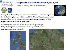
Magnitude 29 LOUGHBOROUGH LEICS UK Friday 18 January 2013 at 052044 UTC The earthquake was felt in the towns of Loughborough Derby Nottingham and Leicester Shaking was felt as far away as Buxton and Warwick ID: 275777

loughborough magnitude january earthquake magnitude loughborough earthquake january 2013 utc friday leics bgs british earthquakes http seismicity survey www

Share:

Link:

Embed:

Download Presentation from below link

Download Presentation The PPT/PDF document "A magnitude 2.9 earthquake occurred in t..." is the property of its rightful owner. Permission is granted to download and print the materials on this web site for personal, non-commercial use only, and to display it on your personal computer provided you do not modify the materials and that you retain all copyright notices contained in the materials. By downloading content from our website, you accept the terms of this agreement.


Presentation Transcript

Slide1

A magnitude 2.9 earthquake occurred in the East Midlands region of the United Kingdom on 18 January 2013. The earthquake occurred at a depth of 13 km (8 miles). Approximately 26 earthquakes of this magnitude occur in the UK every year.

Magnitude 2.9 LOUGHBOROUGH, LEICS, UK

Friday, 18 January, 2013 at 05:20:44 UTC

The earthquake was felt in the towns of

Loughborough

, Derby, Nottingham and Leicester. Shaking was felt as far away as Buxton and Warwick.Slide2

Magnitude 2.9 LOUGHBOROUGH, LEICS, UK

Friday, 18 January, 2013 at 05:20:44 UTC

Where was it felt?

Maximum recorded intensity was IV in Loughborough

Modified

Mercalli

Intensity Scale (courtesy of University of Alberta)

Location of earthquake felt reports (image courtesy of BGS)Slide3

Magnitude 2.9 LOUGHBOROUGH, LEICS, UK

Friday, 18 January, 2013 at 05:20:44 UTC

Earthquake and historic seismicity

The earthquake

epicentre

(red star) is plotted on the map with regional seismicity since 1960.

Historic seismicity of the British Isles

Historic seismicity

in the region of the mainshock (image courtesy of BGS)Small earthquakes have been known to occur in this region of the UK before. Slide4

Magnitude 2.9 LOUGHBOROUGH, LEICS, UK

Friday, 18 January, 2013 at 05:20:44 UTC

Tectonic interpretation

Although the UK does not lie on an active tectonic plate boundary (one of its nearest plate boundary being the Mid-Atlantic Ridge), stress within the plate is released along pre-existing faults within the crust. In areas of low seismicity, such as the British Isles, it is difficult to identity the causative fault. Furthermore, with such low-magnitude events, it is not possible to determine the earthquake’s focal mechanism.

Mid-Atlantic

RidgeSlide5

Magnitude 2.9 LOUGHBOROUGH, LEICS, UK

Friday, 18 January, 2013 at 05:20:44 UTC

Aftershocks

Since the earthquake, two aftershocks have been recorded by the British Geological survey. The largest of these occured

on 04/02/13 with a magnitude of 2.4, and was located to the south-east of the mainshock.

Aftershocks (red circles) recorded by the British Geological Survey in this region following the

mainshock (red star).Slide6

Magnitude 2.9 LOUGHBOROUGH, LEICS, UK

Friday, 18 January, 2013 at 05:20:44 UTC

Seismogram recordings from UK schools

Paulet High School, Burton on Trent (PAUL)

Loughborough High School (LHSUK)

School Seismometer at the

University of Liverpool (DEOS)Slide7

Magnitude 2.9 LOUGHBOROUGH, LEICS, UK

Friday, 18 January, 2013 at 05:20:44 UTC

Seismogram recordings from BGS network and locating the earthquake

By finding the arrival time difference between the P and S waves, we can calculate the distance of the earthquake from the seismometer station. If we do this for several stations, we can determine the approximate

epicentre

of the earthquake by finding where these circles intersect.Slide8

Find out more…

BGS (British Geological Survey) – seismology and earthquakes – frequently asked questions

http://www.earthquakes.bgs.ac.uk/education/faqs/faq_index.html

IRIS (Incorporated Research Institutions for Seismology) – learning about earthquakes

http://www.iris.edu/hq/programs/education_and_outreach/students

UK School Seismology Project – classroom activities, videos and support documents

http://www.bgs.ac.uk/schoolseismology/home.html

USGS (United States Geological Survey) – FAQs, glossary, posters, animations

http://earthquake.usgs.gov/learn/EMSC (European Mediterranean Seismological Centre) http://www.emsc-csem.org/Magnitude 2.9 LOUGHBOROUGH, LEICS, UK Friday, 18 January, 2013 at 05:20:44 UTC