PPT-AGU, 2003 Greenland Iceland
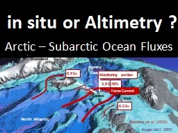
Shet land Faroes imageAGU 2003 Combining satellite altimetry and in situ observations to monitor transports of volume heat and salt in the Faroe Current Bogi
Download Presentation
"AGU, 2003 Greenland Iceland" is the property of its rightful owner. Permission is granted to download and print materials on this website for personal, non-commercial use only, provided you retain all copyright notices. By downloading content from our website, you accept the terms of this agreement.
Presentation Transcript
Transcript not available.