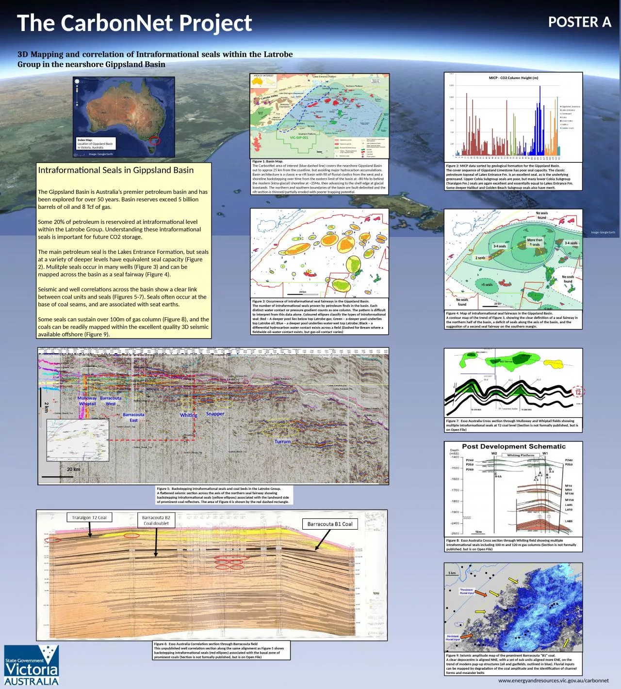
PPT-Figure 2: MICP data sorted by geological formation for the Gippsland Basin.
Author : heavin | Published Date : 2023-10-04
The cover sequence of Gippsland Limestone has poor seal capacity The classic petroleum topseal of Lakes Entrance Fm is an excellent seal as is the underlying greensand
Presentation Embed Code
Download Presentation
Download Presentation The PPT/PDF document "Figure 2: MICP data sorted by geological..." is the property of its rightful owner. Permission is granted to download and print the materials on this website for personal, non-commercial use only, and to display it on your personal computer provided you do not modify the materials and that you retain all copyright notices contained in the materials. By downloading content from our website, you accept the terms of this agreement.
Figure 2: MICP data sorted by geological formation for the Gippsland Basin.: Transcript
The cover sequence of Gippsland Limestone has poor seal capacity The classic petroleum topseal of Lakes Entrance Fm is an excellent seal as is the underlying greensand Upper Cobia Subgroup seals are poor but many lower Cobia Subgroup Traralgon Fm seals are again excellent and essentially equal to Lakes Entrance Fm Some deeper Halibut and Golden Beach Subgroup seals also have merit. The Gippsland Massacres. Fighting against the invasion. The Gippsland Massacres was . the fight between . the Australian . i. ndigenous tribe . of Gunai (Kurnai) . and . the European settlers in Gippsland, Victoria from 1840-1850. Eregli-Ulukisla. Basin. Ayfer ÖZDEMİR. CONTENT. Aim. Why. ?. Study. . Area. Geology. of . the. . study. . area. Petroleum Reservoir Rock Properties . of . Guney . Formation. Petrographic . Examinations. . Assistance for County Plans. David E. Tabet, Manager. Energy and Minerals Program. Utah Geological Survey. 1594 W. North Temple, suite 3100. 801-537-3373. davidtabet@Utah.gov. January 13, 2016. Outline. Challenge Reconnaissance. 27 April 2017. Challenge Recon Background. First Annual Challenge Reconnaissance. Dedicated . to . Bn, Squadron or parent unit KIA. Pre-requisites: . Active Duty Marine, team comes from the same command, LCpl or above, current. Precaspian. petroleum basin at the present stage. Speaking notes for. . XI KAZENERGY Eurasia Forum . A global trend for transfer to renewable energy is on the rise and this encouraging phenomenon of the present time is demonstrated convincingly at the EXPO 2017 International specialized exhibition “Future Energy” in Astana, has given impetus and laid the basis for. Sorting can be custom according to the type of nodes. Offers speedups over non-sorted list. Inserting into a sorted linked list. Similar to before, but we will remove the need to “append” nodes to our list. 1. GIS Term Project. Julien Botto. What is geological carbon sequestration ?. 2. M. ain . parameters for GCS in deep saline aquifers . 3. Potential formation candidates. Mt.Simon. sandstone is the best candidate. La gamme de thé MORPHEE vise toute générations recherchant le sommeil paisible tant désiré et non procuré par tout types de médicaments. Essentiellement composé de feuille de morphine, ce thé vous assurera d’un rétablissement digne d’un voyage sur . ; -3 , By L. ' - Geologic ^UNITED UNITED Secretary GEOLOGICAL Director For CONTENTS Page Abstract. rocks.________________________________-______--------- IV ILLUSTRATIONS Pillars 4. TABLE Geo 281: geology for engineers. Geology and Geophysics Department. King Saud University. ROCK . DEFORMATION (STRESS). Tectonic forces exert different types of stress on rocks in different geologic environments. . DESCRIPTION OF A GEOLOGICAL MAP. Preamble. The main objective of training in geological map interpretation is to identify as accurate as possible with the aid of diagrams and sections the features depicted on maps. . Thomas Oommen, . Associate Professor. Michigan Technological University, Michigan. Content. Introduction. Principles of Engineering Geological . M. apping (EGM). How to make engineering geological maps. OLUWOLE A. OYEDEJI . PRESENTATION OUTLINE. Sedimentary Basins. Location. Dahomey. OR Benin . Basin . –Origin and . Morphology. Geology . of . Ogun. . state. Economic Geology. Geotourism. sites. Research . Institute. A geological study of the lower Ecca Group, north of Grahamstown, South-East Karoo Basin, South Africa. S Slamang. 1. , . P.W.K Booth. 2. , D Mikeš. 3. , M.J de Wit. 4. 1-4. . Department of .
Download Document
Here is the link to download the presentation.
"Figure 2: MICP data sorted by geological formation for the Gippsland Basin."The content belongs to its owner. You may download and print it for personal use, without modification, and keep all copyright notices. By downloading, you agree to these terms.
Related Documents