/
Franklin T. Heitmuller Assistant Professor Franklin T. Heitmuller Assistant Professor

Franklin T. Heitmuller Assistant Professor - PowerPoint Presentation

heavin
heavin . @heavin
Follow
68 views
Uploaded On 2023-10-26

Franklin T. Heitmuller Assistant Professor - PPT Presentation

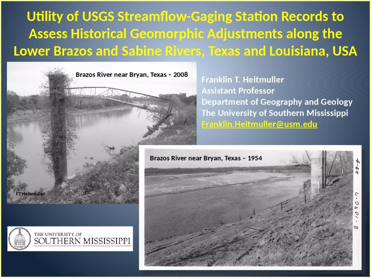
Department of Geography and Geology The University of Southern Mississippi FranklinHeitmullerusmedu Brazos River near Bryan Texas 2008 Utility of USGS Streamflow Gaging Station Records to Assess Historical Geomorphic Adjustments along the Lower Brazos and Sabine Rivers Texas and L ID: 1025054

area river methods study river area study methods background texas channel 2009 brazos historical sabine cross greene water flow

Share:

Link:

Embed:

Download Presentation from below link

Download Presentation The PPT/PDF document "Franklin T. Heitmuller Assistant Profess..." is the property of its rightful owner. Permission is granted to download and print the materials on this web site for personal, non-commercial use only, and to display it on your personal computer provided you do not modify the materials and that you retain all copyright notices contained in the materials. By downloading content from our website, you accept the terms of this agreement.


Presentation Transcript

1. Franklin T. HeitmullerAssistant ProfessorDepartment of Geography and GeologyThe University of Southern MississippiFranklin.Heitmuller@usm.eduBrazos River near Bryan, Texas – 2008Utility of USGS Streamflow-Gaging Station Records to Assess Historical Geomorphic Adjustments along the Lower Brazos and Sabine Rivers, Texas and Louisiana, USAFT HeitmullerBrazos River near Bryan, Texas – 1954

2. Background Methods Study Area Example Results5.0 m5.0 m5.0 m5.0 m5.0 m5.0 m0.0 m0.0 m1.0 m1.2 m1.1 m1.0 m0.5 mVelocity at 0.2 depthVelocity at 0.8 depth0.5 m/s0.2 m/s0.7 m/s0.3 m/s0.8 m/s0.3 m/s0.7 m/s0.3 m/s0.4 m/s0.2 m/s0.2 m/s0.1 m/sUSGS Streamflow-Gaging Station Operationshttp://ga.water.usgs.gov/edu/measureflow.htmlViewed on September 20, 2007AAUUQ = AU,where Q is discharge (m3/s);A is cross-sectional area (m2); andU is mean flow velocity (m/s).

3. Background Methods Study Area Example ResultsUSGS Streamflow-Gaging Station RecordsThis is what the public can access from the web.Used to have total water-surface width, mean depth, and mean velocity.What if divided among multiple channels?USGS Form 9–207

4. Background Methods Study Area Example ResultsFrom Leopold et al. (1964)Leopold, L.B., Wolman, M.G., and Miller, J.P., 1964, Fluvial processes in geomorphology: San Francisco, W.H. Freeman and Company, 522 p.Previous InvestigationsScour-and-FillHydraulic GeometryFrom Leopold et al. (1964)FT HeitmullerBrazos River at Richmond, Texas

5. Background Methods Study Area Example ResultsPrevious InvestigationsJuracek, K.E., 2001, Channel-bed elevation changes downstream from large reservoirs in Kansas: U.S. Geological Survey Water-Resources Investigations Report 2001–4205, 24 p.Juracek, K.E., and Fitzpatrick, F.A., 2009, Geomorphic applications of stream-gage information: River Research and Applications, v. 25, p. 329–347.Stage at mean annual dischargeFrom Juracek and Fitzpatrick (2009)Channel incisionFrom Juracek (2001)Channel incisionFT HeitmullerBrazos River near Highbank, Texas

6. Background Methods Study Area Example ResultsUSGS Streamflow-Gaging Station RecordsBehind the Scenes of USGS NWIS

7. Background Methods Study Area Example ResultsUSGS Streamflow-Gaging Station RecordsBottom Line → If…A measurement section has maintained consistent horizontal sectioning across the channel ANDThe WGH can be corrected for adjustments to local vertical gage datumthen → historical cross-section geometry can be reconstructed.

8. Background Methods Study Area Example ResultsRendering Historical Cross SectionsData digitized directly from hard-copy measurement notesWGH (water surface) – water depth = gage height of channel boundaryPlot gage height of channel boundary and section distance

9. Background Methods Study Area Example ResultsRendering Historical Cross SectionsSection distance

10. Background Methods Study Area Example ResultsRendering Historical Cross SectionsPrecaution #1 → Unique location and conditionStreamflow-gaging locations selected for presence of “controls” (e.g., submerged bedrock shelves, confined valleys)Possibly not representative of typical hydraulicsCommonly zone of minimal alluvial adjustment → stable stage-discharge relations through timePossibly represents a “conservative” estimate of channel changeFT HeitmullerLlano River near Junction, Texas

11. Background Methods Study Area Example ResultsRendering Historical Cross SectionsPrecaution #2 → Consistent horizontal sectioningArbitrary horizontal distance across channelCommonly marked with paint on bridges or cablesIf section numbers change, some inferences can still be madeWading measurements not possible

12. Background Methods Study Area Example ResultsJuracek, K.E., and Fitzpatrick, F.A., 2009, Geomorphic applications of stream-gage information: River Research and Applications, v. 25, p. 329–347.From Juracek and Fitzpatrick (2009)Rendering Historical Cross SectionsPrecaution #3 → Vertical stage datum shiftsNew gage construction / replacement / relocationUSGS Station Description sheets contain necessary information for corrections

13. Background Methods Study Area Example ResultsRendering Historical Cross SectionsPrecaution #4 → Bridge hydraulicsHighway embankments → concentrate flow energy through the measurement sectionBridge piers and abutments → increase flow resistance at the measurement sectionCableways optimalFT HeitmullerLittle River near Cameron, Texas FT HeitmullerLlano River at Llano, Texas

14. Background Methods Study Area Example ResultsRendering Historical Cross SectionsPrecaution #5 → Bridge construction and repairConstruction activities involving considerable excavation and changes to channel configurationNational Bridge Inventory → provides date of last replacement or rehabilitation projecthttp://nationalbridges.com/FT HeitmullerNavasota River near Easterly, Texas Navasota River near Easterly, Texas 1941

15. Background Methods Study Area Example ResultsRendering Historical Cross SectionsPrecaution #6 → Baseflow / low-flow measurementsBaseflow and low-flow measurements → only channel-bed geometryLittle to no channel bank geometry

16. Background Methods Study Area Example ResultsRendering Historical Cross SectionsPrecaution #7 → Scour-and-fill processesSand-bed channels especially susceptibleExacerbated during high flowsPost-flood recovery timeHeitmuller, F.T., and Greene, L.E., 2009, Historical channel adjustment and estimates of selected hydraulic values in the lower Sabine River and lower Brazos River Basins, Texas and Louisiana: U.S. Geological Survey Scientific-Investigations Report 2009–5174, 143 p.From Heitmuller and Greene (2009)

17. Background Methods Study Area Example ResultsLower Brazos and Sabine RiversHeitmuller, F.T., and Greene, L.E., 2009, Historical channel adjustment and estimates of selected hydraulic values in the lower Sabine River and lower Brazos River Basins, Texas and Louisiana: U.S. Geological Survey Scientific-Investigations Report 2009–5174, 143 p.From Heitmuller and Greene (2009) Upper Brazos River → considerable impoundment along main stem channel Lower Brazos River → NO impoundments along main stem Lower Brazos tributaries → considerable impoundment Lower Sabine River → Toledo Bend Reservoir Both primarily sand bed

18. Background Methods Study Area Example ResultsFrom Dunn and Raines (2001)Dunn, D.D., and Raines, T.H., 2001, Indications and potential sources of change in sand transport in the Brazos River, Texas: U.S. Geological Survey Water-Resources Investigations Report 01–4057, 32 p.Phillips, J.D., 2003, Toledo Bend Reservoir and geomorphic response in the lower Sabine River: River Research and Applications, v. 19, p. 137–159.Lower Brazos and Sabine Rivers Lower Brazos River → channel-bed incision documented (Dunn and Raines, 2001) Lower Sabine River → incision only documented immediately downstream of Toledo Bend (Phillips, 2003)From Dunn and Raines (2001)From Phillips (2003)Lower BrazosLower BrazosLower Sabine

19. Background Methods Study Area Example Results08030500 Sabine River near Ruliff Lowermost gaging station Measurement section relocated in late 1970s 1961 – 1979 → Stable cross section 1977 – present → Scour and fill, but overall stabilityHeitmuller, F.T., and Greene, L.E., 2009, Historical channel adjustment and estimates of selected hydraulic values in the lower Sabine River and lower Brazos River Basins, Texas and Louisiana: U.S. Geological Survey Scientific-Investigations Report 2009–5174, 143 p.From Heitmuller and Greene (2009)

20. Background Methods Study Area Example Results08030500 Sabine River near RuliffHeitmuller, F.T., and Greene, L.E., 2009, Historical channel adjustment and estimates of selected hydraulic values in the lower Sabine River and lower Brazos River Basins, Texas and Louisiana: U.S. Geological Survey Scientific-Investigations Report 2009–5174, 143 p.From Heitmuller and Greene (2009)Temporary aggradation?

21. Background Methods Study Area Example Results08114000 Brazos River near RosharonHeitmuller, F.T., and Greene, L.E., 2009, Historical channel adjustment and estimates of selected hydraulic values in the lower Sabine River and lower Brazos River Basins, Texas and Louisiana: U.S. Geological Survey Scientific-Investigations Report 2009–5174, 143 p.From Heitmuller and Greene (2009)1967 – 2000 → 10.5 feet (3.2 meters) of thalweg incisionChannel bench development

22. Background Methods Study Area Example Results08114000 Brazos River near RosharonUpstream propagation of incision from dredging operations at Freeport?1929

23. SummaryHistorical USGS streamflow-gaging station records can be effectively utilized to assess geomorphic adjustments of riversHard-copy digitization of streamflow measurements permits a more comprehensive evaluation of cross-sectional adjustment Precautions should be taken to eliminate alternative explanations for change and ensure accurate interpretationsDespite the presence of a large, main-stem reservoir, the lowermost Sabine River displays geomorphic stability relative to the lower Brazos River, which has incised → probably because of downstream dredging operations

24. Support for this research came from the following: Texas Water Development Board (TWDB) U.S. Geological Survey (USGS) Texas Water Science Center Lauren E. GreeneBrazos River near Bryan, TexasAcknowledgmentsFT Heitmuller

25. Background Methods Study Area Example ResultsTexas Instream Flow Program Texas Senate Bill 2 (2001) → “conduct studies and analyses to determine appropriate methodologies for determining flow conditions in the state’s rivers and streams necessary to support a sound ecological environment” focused investigations of hydrology, biology, geomorphology, and water qualityGeomorphic “flows”What should the channel geometry be?Texas Environmental Flows Science Advisory Committee, 2009, Use of hydrologic data in the development of instream flow recommendations for the environmental flows allocation process and the hydrology-based environmental flow regime (HEFR) methodology: Austin, Tex., accessed on September 9, 2009, at http://www.tceq.state.tx.us/assets/public/permitting/watersupply/water_rights/eflows/hydrologicmethods04202009.pdfFrom Texas Environmental Flows Science Advisory Committee (2009)