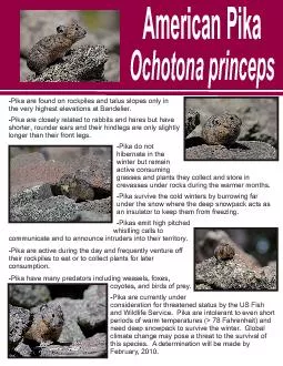
PPT-1 SNOWPACK AND FRESHWATER ICE SENSING USING AUTOCORRELATION
Author : karlyn-bohler | Published Date : 2016-12-17
RADIOMETRY A W Tony England Hamid Nejati and Amanda Mims University of Michigan Ann Arbor Michigan US A IGARSS 2011 Outline Intro to global snowpack sensing
Presentation Embed Code
Download Presentation
Download Presentation The PPT/PDF document "1 SNOWPACK AND FRESHWATER ICE SENSING US..." is the property of its rightful owner. Permission is granted to download and print the materials on this website for personal, non-commercial use only, and to display it on your personal computer provided you do not modify the materials and that you retain all copyright notices contained in the materials. By downloading content from our website, you accept the terms of this agreement.
1 SNOWPACK AND FRESHWATER ICE SENSING USING AUTOCORRELATION: Transcript
RADIOMETRY A W Tony England Hamid Nejati and Amanda Mims University of Michigan Ann Arbor Michigan US A IGARSS 2011 Outline Intro to global snowpack sensing Limitations of current snowpack sensing technologies. data . Edward Park. SAC in MATLAB. Digital Globe inc.. Introduction. 1.1 Objective. Objective: . To do the . accuracy assessment. of various classification of raster pixels. . Why?. The . ultimate goal of Geographic Information System (GIS) is to model our world. However, the modeling process is too complicated and requires elaborateness that we should not rely entirely on computer. . Sam Sartwell, . Winter Ecology, EBIO 4100, Spring 2014, CU Mountain Research Station, CU Boulder. Putting this question in a winter ecological perspective. The purpose of the study is to understand the differences in the snowpack between these two areas. . Dylan Brown. Winter Ecology Spring 2014. Mountain Research Station, University of Colorado Boulder. Introduction. Mountain pine beetles are increasing the number of dead trees in our forests. Dead trees with no remaining needles intercept less snow and solar radiation than live trees (Pugh and Small, 2011). Presentation: Liz Westby. Assistant: Esther Duggan. October 30, 2012. Description. GISP2 Ice Core. Identified in lacustrine sedimentary sequences in northern Sweden in 1976 (Head, 2007); found in Greenland ice core. Endemism . and . Vulnerability . in California: the Freshwater Conservation Blueprint. Joseph Furnish (US Forest Service). Jeanette Howard, Kirk . Klausmeyer. (The Nature Conservancy). Kurt Fesenmyer (Trout Unlimited. data . Edward Park. SAC in MATLAB. Digital Globe inc.. Introduction. 1.1 Objective. Objective: . To do the . accuracy assessment. of various classification of raster pixels. . Why?. The . ultimate goal of Geographic Information System (GIS) is to model our world. However, the modeling process is too complicated and requires elaborateness that we should not rely entirely on computer. . Seasonal . V. ariations . of . Nitrogen . O. xides Within . S. nowpack . A. ir . and the . Overlying . A. tmosphere . at Summit, Greenland. C. Toro. 1. , R.E. Honrath. 1. †. , L.J. Kramer. 1. , D.Helmig. Jeff Dozier – UCSB. NASA Snow Remote Sensing Workshop. Boulder, August 2013. Different concepts in different parts of spectrum. Visible, near-infrared, and infrared. Independent scattering. Weak polarization. . CO. 2. and O. 2. from air and water. . Autochthonous vs. . allochthonous. inputs. . Lake factors:. . Geography/topography. . . Nutrient sources. Size. Age. Lakes stratify and mix differently based on these factors. American PikaOchotona princeps Objective. To explore the fate of the BG freshwater after it is released and to quantify its downstream impact on the subpolar North Atlantic salinity.. Findings. BG freshwater exited the Arctic mostly through the Canadian Arctic Archipelago, rather than . Question 1.. Which of the following is not a freshwater source? . Ditch. Ocean . Canal . Lake . Question 2. .. Roughly how much of the Earth’s surface is covered by freshwater?. Half . Two thirds . A. FRESHWATER ON EARTH. 70% of Earth is covered in water.. 3% of Earth’s water is freshwater (97% saltwater). FRESHWATER CONTAINS LESS THAN 1% SALT. 68.7% of FRESHWATER is frozen in glaciers and icecaps. Computational Earth Science. Bill Menke, Instructor. Emily Glazer, Teaching Assistant. TR 2:40 – 3:55. Today. Use of the Fast Fourier Transform in Modeling. “random textures”. of natural phenomenon.
Download Document
Here is the link to download the presentation.
"1 SNOWPACK AND FRESHWATER ICE SENSING USING AUTOCORRELATION"The content belongs to its owner. You may download and print it for personal use, without modification, and keep all copyright notices. By downloading, you agree to these terms.
Related Documents