/
Capes Capes

Capes - PowerPoint Presentation

kittie-lecroy
kittie-lecroy . @kittie-lecroy
Follow
373 views
Uploaded On 2016-02-27

Capes - PPT Presentation

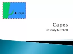
Cassidy Mitchell In geography a cape is a headland or a promontory of large size extending into a body of water usually the sea What are they A cape usually represents a marked change in trend of the coastline Their proximity to the coastline makes them prone to natural forms of erosion m ID: 233813

sea cape juby county cape sea county juby capes level erosion ras kasar coastline morocco western border sahara eritrea

Share:

Link:

Embed:

Download Presentation from below link

Download Presentation The PPT/PDF document "Capes" is the property of its rightful owner. Permission is granted to download and print the materials on this web site for personal, non-commercial use only, and to display it on your personal computer provided you do not modify the materials and that you retain all copyright notices contained in the materials. By downloading content from our website, you accept the terms of this agreement.


Presentation Transcript

Slide1

Capes

Cassidy MitchellSlide2

In geography, a cape is a headland or a promontory of large size extending into a body of water, usually the sea.

What are they?Slide3

A cape usually represents a marked change in trend of the coastline. Their proximity to the coastline makes them prone to natural forms of erosion, mainly tidal

actions. This results in capes having a relatively short geologic lifespan. Capes can be formed by glaciers, volcanoes, and changes in sea level. Erosion plays a large role in each of these methods of formation.

How do they form?Slide4

Ras

Kasar is a cape in northeastern Africa, on border between Eritrea and Sudan at the Red Sea. It is the northernmost point in Eritrea and the easternmost point in Sudan.

Ras

KasarSlide5

Grand Cape Mount is

a county in the northwestern portion of the West African nation of Liberia. One of 15 counties that comprise the first-level of administrative division in the nation, it has five districts.The area

of the county

measures

5,162 square kilometers (1,993

sq

mi).

As of the 2008 Census, it had a population of 129,055, making it the

eighth

most populous county in Liberia.

Grand Cape Mount Slide6

Cape

Juby is on the coast of southern Morocco, near the border with Western Sahara, directly east of the Canary Islands.

Cape

Juby

is

in a way a semi-

desertic

buffer zone between Morocco proper and the Western Sahara, and was under Spanish rule in the first half of the 20th century.

Cape

Juby