/
Trinity Lake Revitalization Alliance PO Box 128, Trinity Center. CA 96 Trinity Lake Revitalization Alliance PO Box 128, Trinity Center. CA 96

Trinity Lake Revitalization Alliance PO Box 128, Trinity Center. CA 96 - PDF document

kittie-lecroy
kittie-lecroy . @kittie-lecroy
Follow
460 views
Uploaded On 2015-08-31

Trinity Lake Revitalization Alliance PO Box 128, Trinity Center. CA 96 - PPT Presentation

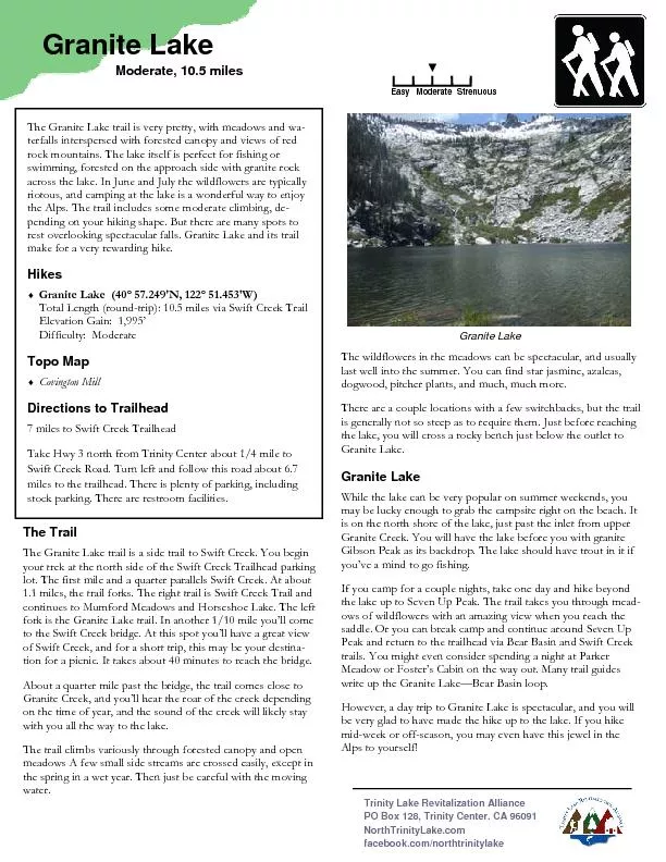
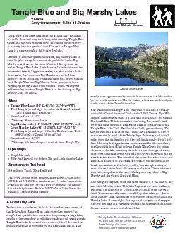
Tangle Blue and Big Marshy Lakes Easy to moderate that stands in contrajust to north such as the Marshy Lakes which are in the red peridotite veins of the Scott Mountains The Tangle Blue Lake h ID: 119599

Tangle Blue and Big Marshy

Share:

Link:

Embed:

Download Presentation from below link

Download Pdf The PPT/PDF document "Trinity Lake Revitalization Alliance PO ..." is the property of its rightful owner. Permission is granted to download and print the materials on this web site for personal, non-commercial use only, and to display it on your personal computer provided you do not modify the materials and that you retain all copyright notices contained in the materials. By downloading content from our website, you accept the terms of this agreement.


Presentation Transcript

Trinity Lake Revitalization Alliance PO Box 128, Trinity Center. CA 96091 NorthTrinityLake.com facebook.com/northtrinitylake Tangle Blue and Big Marshy Lakes Easy to moderate, that stands in contrajust to north, such as the Marshy Lakes, which are in the red peri-dotite veins of the Scott Mountains. The Tangle Blue Lake hike from the Tangle Blue Trailhead is a fairly short and easy trail along swift-moving Tangle Blue Creek and through lush meadows and under forest canopy Easy Moderate Strenuous A Great Day Hike Tucked into a handsome basin in the northeastern corner of the Trinity Alps, Tangle Blue Lake combines many of the range’s best qualities into one attractive package: a large lake, swaths of lush meadow, a rollicking creek and tall granite peaks. Tangle Blue Lake is located on the north side of the massive granite bulge that is occupied by the Bear Lakes Basin. This Tangle Blue and Big Marshy Lakes Most of Little Marshy Lake is on private land, and there are some minor improvements at the east end of the lake. Don’t disturb the private facilities. The entire basin, including part of Tangle Blue basin, is often used for summer grazing for cattle. Therefore, watch out for the cattle droppings on the trail, and site carefully! Though there are no boundary markers, the Grand National Trail begins at the boundary of a privately owned section of land. This is why the first 1.3 miles of trail are, in fact, an old road as it crosses the section. From the parking area, head west downhill toward Tangle Blue Creek, passing a gate almost imme-diately. Cross the creek on a bridge built of thick steel plates bordered with telephone poles stretching across the water. Be-yond the bridge the trail makes a sharp turn to the left and be-gins the steepest climb of the entire trail, which switchbacks af-ter 0.1 mile and again follows the creek, this time higher up. The road continues all the way to the boundary of the Trinity Alps Wilderness, where you’ll find a USFS gate. Just prior to the wilderness boundary the trail deviates from the old road for the first time. The road continues on the private land, but the trail turns to the right, crossing an earthen mound that blocks wilderness access to vehicles. Though it is not obvi-ous here, this route was also at one time a dirt road but nature has been chipping away at it long enough that it looks like nor-mal single-track at the this point. The creek, still off to the right of the trail, is accessible via eabankment to swimming holes and rapids. Shortly after becoming a regular trail, the route enters a small but scenic meadow, though the trail skirts the northern edge of the grassy area rather than crofew small, spring-fed streams and reaching the far end of the meadow, the trail makes a very short descent down to a Tangle very high, it is easy to hop across the creek on rocks. Just prior to crossing an extremely faint trail branches off to the left and climbs up to the ruins of the Grand National Mine. This route is no longer maintained.Once across the creek, the trail does one switchback to gain some elevation, and joins rocky Marshy Creek. At about 0.6 miles past the creek crossing, you arrive at the fork to Marshy Lakes. The trail to the upper lakes continues up an old road and after a very short interval becomes the steepest portion of the upper trail. The Marshy Lakes Staying to the left at the fork, the Grand National Trail becomes the Tangle Blue Lake Trail and passes between some enormous cedar trees before breaking out into a large, lovely meadow. Tangle Blue Creek marks the eastern perimeter of the meadow. To the south, the granite spires above Tangle Blue Lake become visible for the first time, indicating that the trail is nearing its end as you approach the lake.While passing through the meadow, the trail moves closer to the creek and then makes a short drop down to its banks. Crossing the creek, the trail enters thick woods again. The map marks this area as the site of the Messner Cabin. Nothing remains now ex-cept a heavy duty old oven. Still, it comes as a bit of a surprise this far out in the wilderness. Beyond the cabin site, the trail be-gins its final ascent up to Tangle Blue Lake. The climb is about ½ mile. Although it is mostly in the shade, it does at times have direct sunlight on it and may get hot later in the day. Fortunately there is a cure for that just a short distance away. Finally, the trail emerges from the trees and enters another lovely meadow as the path levels off. The lake and the massive granite headwall are now visibleBy no means the grandest lake in the Trinity Alps, Tangle Blue Lake is nonetheless a fine specimen of an alpine lake. Campsite are abundant. The ones around the outlet are particularly nota-ble, where old Forest Service ovens are constructed. The iron plate griddles have been removed recently but the old rock and concrete structures remain. All in all, it is a great place to camp. Big Marshy Lake Returning to the fork in the trail 2.5 mile from the trailhead, tak-ing the fork to the right begins the ascent to Big and Little Marshy Lakes. If you made the trip to Tangle Blue first, there is a shortcut that saves ¼ mile. When you cross Tangle Blue Creek at Messner’s cabin, don’t take the trail back to the fork. Cross the meadow uphill to its northwest corner and rejoin the trail westbound. But if you’re just coming up from the trailhead, stay right at the fork. There are two signs pointing the way to Marshy that you are joining route 8W01. The steep ascent only lasts 0.4 miles, and as the trail flattens out, it reenters private land. Almost immediately, you encounter a meadow that the maps shows has a small pond. Across the meadow is a platform for a tent and a horse camp. If you follow the trail, or explore the meadow, you will encounter an old road on the north side of the meadow. Follow the road until you come to another meadow. Look for the trail to continue to the west. If you stay on the road until you Big Marshy Lake Tangle Blue and Big Marshy Lakes reach a creek crossing, you’ve gone too far. The trail is in the trees at the south end of the meadow. This trail will take you to Little Marshy Lake. As you arrive at the lake, you will encounter some private facili-ties, including and A-frame outhouse, and a granite counter and sink. Again, these are private facilities that should remain undis-If you make your way north across the creek outlet, you should find a faint trail along the tree line. This trail will climb the hill north of Little Marshy Lake. Listen for the waterfall, and if you make about an 80 yard diversion, you can get a great shot of the Marshy Creek waterfall cascading down some big boulders. If you went to the falls, make your way back to the trail and continue up to Big Marshy Lakebasin from the south side is spectacular, but you’ll want to take the trail around the lake to the north side and view the lake and the mountains to the southeast. That is the granite bulge of the Bear Creek area. From the north side of the lake, hike up and over the north rim of the lake until you encounter the trail running east-west. This is the Boulder Lake Trail, and you turn right to follow it along the south side of a meadow, and then just stay on this trail until it turns into an old road. Follow the road, and eventually you will be paralleling Marshy Creek. You will come to a side trail that crosses the creek and turns the road you took in the opposite direction after the climb up from the Grand National Trail. Take the road back to the meadow that had the tent platform, and look for the trail along the east side of that meadow. Follow the trail back down to the steep portion that takes you back down to the Grand National Trail. Your return hike from Big Marshy Lake to the trailhead will be about 4 2/3 miles. If you’ve combined Tangle Blue with the Big Marshy hike, you’ll end up with about 10.9 miles under your shoes. If you just hiked the Marshy Lakes, it’s about 9.2 miles. Either way, you’ve had a wonderful day hike to some beautiful Alps lakes. Elevation profile for the hike to Tangle Blue Lake — an elevation gain of about 1,160’ over 3.3 miles Elevation profile for the hike to Marshy Lakes loop — an elevation gain of 1,730’ over 4.3 miles. Fork between Tangle Blue and Marshy Lakes trails Little Marshy Lake Big Marshy Lake Marshy Lakes loop fork C Rev A Tangle Blue Lake — Marshy Lakes Map