/
Meteorology – Jet Streams Fronts and Air Masses Meteorology – Jet Streams Fronts and Air Masses

Meteorology – Jet Streams Fronts and Air Masses - PowerPoint Presentation

lois-ondreau
lois-ondreau . @lois-ondreau
Follow
431 views
Uploaded On 2017-12-22

Meteorology – Jet Streams Fronts and Air Masses - PPT Presentation

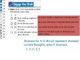
Connecting the Weather Air Masses Fronts Jet Stream Quiz Midweek Seminars Meteorology Jet Streams Fronts and Air Masses Air Masses A mass of air takes on Temperature and Moisture from where the ID: 617372

masses air streams jet air masses jet streams fronts meteorology midweek seminars mass cold source moves warm front amp

Share:

Link:

Embed:

Download Presentation from below link

Download Presentation The PPT/PDF document "Meteorology – Jet Streams Fronts and A..." is the property of its rightful owner. Permission is granted to download and print the materials on this web site for personal, non-commercial use only, and to display it on your personal computer provided you do not modify the materials and that you retain all copyright notices contained in the materials. By downloading content from our website, you accept the terms of this agreement.


Presentation Transcript

Slide1

Meteorology – Jet Streams Fronts and Air Masses

Connecting the Weather

Air Masses

FrontsJet StreamQuiz

Midweek SeminarsSlide2

Meteorology – Jet Streams Fronts and Air Masses

Air Masses

A mass

of air takes on Temperature and Moisture from where the source of air originates.Source Region - Land or SeaAmount of Time over the Source regionModification as the Air Mass moves away from the source.

Midweek SeminarsSlide3

Meteorology – Jet Streams Fronts and Air Masses

Air Mass Classification and humidity

Artic – Polar Ice Cap in Winter

Polar – Forms 40’ to 60’, Summer up to 80’Tropical – Forms from high pressure cells, Summer over large continentsEquatorial – Region between Sub tropical HighsHumidity depends on sourceMaritime – Forms over

Water – more humid

Continental – Originates over

Land – less humid

Midweek SeminarsSlide4

Meteorology – Jet Streams Fronts and Air Masses

Midweek Seminars

Air masses affecting the UK a

re either Polar or

Tropical with Artic

air mass in winterSlide5

Meteorology – Jet Streams Fronts and Air Masses

What happens as an Air Mass moves from

Cold to Warm?

Air becomes heated in the Lower LevelsTo pilot this gives you..Unstable AirWarmer AirLow HumidityMidweek Seminars

What happens as an Air Mass moves from

Warm

to

Cold?

To

pilot this gives you..

More stable air

Colder in lower levels

Increased

HumiditySlide6

Meteorology – Jet Streams Fronts and Air Masses

Air Masses

Polar Maritime

Source – Greenland & IcelandConditions at SourceColdStable

High Humidity

As Air Mass moves South East becomes

Unstable resulting in

Cu and

Cb

over Land

Heavy Showers, Rain, Hail

Moderate to severe Icing

Good

Visibility

Midweek SeminarsSlide7

Meteorology – Jet Streams Fronts and Air Masses

Air Masses

Tropical Maritime

Source – AzoresConditions at SourceWarmSlight Instability

Moderate Humidity

As Air Mass moves North East Air cools from

below

Advection Fog

St &

Sc

by day

St at night

Poor

Visibility

Midweek SeminarsSlide8

Meteorology – Jet Streams Fronts and Air Masses

Air Masses – Tropical continental

Source – North Africa

Conditions at SourceWarmStableLow Humidity

As Air Mass moves North it cools from below becomes more stable, Humidity stays low

.

Hot & Dry weather

Poor Visibility due to

Haze

Midweek SeminarsSlide9

Meteorology – Jet Streams Fronts and Air Masses

Air masses, Arctic Maritime,

W

inter only Source – Artic CircleConditions at SourceCold

Stable

Low Humidity

As Air Mass moves South it is heated from below becomes VERY unstable,

Cold

Moist - Precipitation

Heavy Snow

Cu &

Cb

Clouds

Unstable

Possible Thunderstorms

Midweek SeminarsSlide10

Meteorology – Jet Streams Fronts and Air Masses

Air Masses, Polar continental, Winter only

Source – Siberia & North Europe

Conditions at SourceColdStableLow Humidity

As Air Mass moves over cold land of Europe it stays cold and

stable

Cold

Very Dry

No Precipitation

Possible Thunderstorms along east coast if Air Mass has moved over North

Sea

Midweek SeminarsSlide11

Meteorology – Jet Streams Fronts and Air Masses

Midweek SeminarsSlide12

Meteorology – Jet Streams Fronts and Air Masses

Midweek Seminars

Coffee!!!!!Slide13

Meteorology – Jet Streams Fronts and Air Masses

When Air Masses meet we call them… Fronts

A front is a zone of transition between two contrasting air masses

The three types of front areColdWarmOccluded

The interaction of two air masses at the frontal surface frequently gives rise to a great deal of frontal cloud and weather

.

Midweek SeminarsSlide14

Meteorology – Jet Streams Fronts and Air Masses

Fronts

Typical cross section through a frontal system

Midweek SeminarsSlide15

Meteorology – Jet Streams Fronts and Air Masses

Warm front

Midweek SeminarsSlide16

Meteorology – Jet Streams Fronts and Air Masses

Warm Front Weather

Midweek Seminars

Wind veers & increases slightly

Temperature /

Dewpoint

rise.

Pressure steadies

Precipitation changes from RA to DZ or DZRA.

Cloud changes from NS to ST or SC

.Slide17

Meteorology – Jet Streams Fronts and Air Masses

Cold Front

Midweek SeminarsSlide18

Meteorology – Jet Streams Fronts and Air Masses

Cold Front Weather

Midweek Seminars

Pressure rises rapidly

Wind veers and decreases slightly

Temp / Dew point fall.

Visibility improves

Intermittent Rain Heavy Showers begin from NS /

Embd

CbSlide19

Meteorology – Jet Streams Fronts and Air Masses

Midweek SeminarsSlide20

Meteorology – Jet Streams Fronts and Air Masses

Warm Occlusion

Air Masses

FrontsJet StreamQuiz

Midweek Seminars

Less cold air

over-rides

colder air ahead.Slide21

Meteorology – Jet Streams Fronts and Air Masses

Cold Occlusion

Midweek Seminars

Colder air

under-cuts

less cold air aheadSlide22

Meteorology – Jet Streams Fronts and Air Masses

Midweek SeminarsSlide23

Meteorology – Jet Streams Fronts and Air Masses

Jet Streams

Midweek Seminars

A jet stream is an river of high velocity air with velocities of 60 – 250kt, on rare occasions 300kt flowing generally west to east

It is a wind belt in created by thermal wind in a boundary zone between warm and cooler air

i.e.

a frontal zone. It usually separates the colder and warmer air.Slide24

Meteorology – Jet Streams Fronts and Air Masses

Jet Streams

Max wind speed in a Jet Stream is found on the warm side of the frontal zone at an altitude just above than of the cold

tropopause and below that of the warm tropopause and the direction usually agrees with that of the front.Midweek SeminarsSlide25

Meteorology – Jet Streams Fronts and Air Masses

Connecting the Weather

Interpretation of

Wx infoTips for en route Wx interpretation and cross referencing Met chartsExample: F215 shows vis 999 ocnl SHRA 4km vbis cloud 2500 ocnl 1500METAR 9999 BKN 2500 SHRA ; TAF 9999 BKN 2500 PROB30 TEMPO 5000 +SHRAAIRMET Says cold front with gusting winds passing early in day, isolated heavy showers laterConclusion, flight can go ahead, choose alternate carefully and proceed with caution.

Midweek SeminarsSlide26

Meteorology – Jet Streams Fronts and Air Masses

Quiz

Define CAVOK

More than 10k vis, no cloud below 5000ft or MSA, no CuNim in vicinitySHSNRA VV003Heavy showers of snow or rain, vertical visibility 300ftAn airmet says Cold Sector. Conditions?Colder dryer air, good vis, scattered cumulusMETAR :  EGLF 031450Z 02012KT 6000 BKN017 04/00 Q1034. Flyable?

Yes

METAR

:  EGLF 031450Z 02012KT 9000 OVC005 04/04 Q1004. Flyable?

No

TAF says PROB30 TSRA BKN 020 flyable?

Yes with caution

PROB50 Exists?

No, any more than PROB40 is BCMG or TEMPO

Midweek Seminars

Met Office website

Form 214-215

TAFs, METARs, AIRMET

Other sites, XCweather.co.uk, avbrief.co.uk, sky demonSlide27

Meteorology – Why it’s a bad idea to bypass proper Met planning

Midweek Seminars