/
Armuth Ditch Armuth Ditch

Armuth Ditch - PDF document

luanne-stotts
luanne-stotts . @luanne-stotts
Follow
434 views
Uploaded On 2015-09-11

Armuth Ditch - PPT Presentation

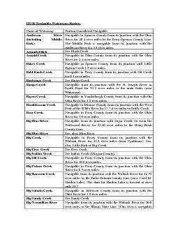
See Black Creek Arnold Creek its junction with the Ohio River for 44 river miles Baker Creek Pigeon Creek 18 river miles Bayou Creek from its junction with the Ohio River for 15 river mile ID: 126582

See Black Creek Arnold Creek

Share:

Link:

Embed:

Download Presentation from below link

Download Pdf The PPT/PDF document "Armuth Ditch" is the property of its rightful owner. Permission is granted to download and print the materials on this web site for personal, non-commercial use only, and to display it on your personal computer provided you do not modify the materials and that you retain all copyright notices contained in the materials. By downloading content from our website, you accept the terms of this agreement.


Presentation Transcript

Armuth Ditch See Black Creek Arnold Creek its junction with the Ohio River for 4.4 river miles. Baker Creek Pigeon Creek 1.8 river miles. Bayou Creek from its junction with the Ohio River for 1.5 river miles. Beanblossom Creek its junction with the West Fork of the White River for 17.7 river miles to Griffy Creek. Bear Creek Navigable in Perry County from its junction with the Ohio Big Deer Creek See Deer Creek. Big Indian Creek See Indian Creek (Morgan County). Big Oil Creek River for 10.6 river miles. Big Sandy Creek See Sandy Creek. Big Vermillion River Navigable from its junction with the Wabash River for 10.8 river miles to the Illinois State Line. (This river is navigable to Carmargo, Illinois.) Black Creek Navigable from its junction with the West Fork of the White River (near Edwardsport) for 11.8 river miles (near Marco). Blue River Navigable from its junction with the Ohio River for 57.15 river miles to Fredricksburg. Blue River See, also, Big Blue River. Bryant Creek y from its junction with the Ohio River for 2.6 river miles. Buck Creek River for 5.8 river miles. Buck Creek River for 0.7 river miles. Buck Run its junction with the Ohio River for 1.1 river miles. Bull Creek Navigable in Clark County from for 1.1 river miles. Bull Hollow Creek for 0.7 river miles. Burns Ditch See Portage Burns Waterway Burns Waterway Lake Michigan for 1.3 river miles to the Little Calumet River. Busseron Creek Navigable from its junction with the Wabash River in Knox County for 20.96 river miles. A ounty (near Rogers Ditch) for 2.85 river miles to its junction Busserou Creek See Busseron Creek. Cagles Mill Lake See Eel River, and see Mill Creek. Calumet River See Grand Calumet River; also Little Calumet River. Calumet River Canal See Indiana Harbor Canal. Cammie Thomas Ditch Navigable for 7.45 river miles as a channelization of the Camp Creek its junction with the Ohio River for 1.7 river miles. Caney Branch Creek for 0.2 river miles. Caney Branch Navigable in Perry County from its junction with Little Deer Creek for 0.8 river miles. Caney Creek River for 2.8 river miles. Carman's Creek See Turman Creek. Cecil M. Harden Lake See Big Raccoon Creek. Clear Creek from its junction with Salt Creek for 2.55 river miles (near Harrodsburg). Clear Creek Navigable from its junction with river miles. Clover Lick Creek Creek for 0.7 river miles. Conns Creek ownership of the creek bed) from its junction with the Flatrock River for 11.5 river miles Crooked Creek River for 7.7 river miles. (including Cypress Creek Diversion Navigable in Warrick County from its junction with the Ohio River for 6.6 river miles. (The for 1.95 river miles, except where the creek bed has emerged Deer Creek River for 5.9 river miles. Driftwood River the East Fork of the White River (near Columbus) 15 river miles to its junction with the Dry Run Creek Blue River for 1.4 river miles. East Calumuck River See Little Calumet River. East Deer Creek Navigable in Perry County from its junction with Deer Creek for 0.6 river miles. East Fork of the White ith the White River 189 river miles to its junction with the Flatrock and Driftwood Rivers (near Columbus). East Fork of the Whitewater River Navigable from its junction with the Whitewater River for 26.25 river miles to the Union-Wayne County Line. Eel River Navigable from its junction with the West Fork of the White Elk Creek Navigable in Washington County from its junction with the Cammie Thomas Ditch for 3.0 river miles. Fanny Creek River for 0.8 river miles. Fawn River Navigable for 13.45 river miles within Indiana. The Fawn River has two navigable segments in Indiana, separated by segments in Michigan. Navigability commences at the Indiana-Michigan state line (near Gilmore Lake and two mile and continues downstream. The Mills (river mile 32). Flat Creek Navigable from its junction wiriver miles (near Otwell). Flatrock River the East Fork of the White River (Columbus) 93 river miles to its uppermost point in Henry County (near Mooreland). Fourteen Mile Creek its junction with the Ohio River for 2.9 river miles. Garrett Creek River for 2.2 river miles. Goose Creek y from its junction with the Ohio River for 1.5 river miles. Grand Calumet River ate Line (near Hammond) for 15.4 river miles to Marquette Grants Creek y from its junction with the Ohio River for 2.5 river miles. Great Miami River Navigable for 1.4 river miles in Dearborn County. (Most of this river lies within Ohio; the Great Miami River has been determined to be navigable from its junction with the Ohio River for 117 river miles. The waterway enters Indiana at two Harden Lake See Big Raccoon Creek. Harris Ditch its junction with the Ohio River for 0.9 river miles to Little Pitcher Lake. Hogan Creek (including North Fork and South Fork): The Main Stem of) Hogan CreekCounty from the junction on the Ohio River for its entire length of 0.4 river miles. The the junction with Hogan Creek for 4.9 river miles. The South river miles. Honey Creek River for 1.8 river miles. Houchins Ditch See Patoka River. Hurricane Fork See Little Fork of Big Creek. Independence Creek See Indian Creek Harrison County). Indian Creek River for 4.8 river miles. Indian Creek Navigable in Martin County from its junction with the East river miles to the Lawrence- Indian Creek its junction with the West Fork of the White River for 3.3 river miles (near Martinsville). Indian Creek y from its junction with the Ohio River for 4.1 river miles. Indian Fork Creek for 1.4 river miles. Indian-Kentuck Creek from its mouth on the Ohio River for 3.8 river miles. Indiana Harbor and The (Main Stem of the) Indiana Harbor and Ship Canal is Ship Canal (including river miles from the Indiana Harbor to where it branches into the Calumet River Canal and on of the Main Stem that is manmade land comprising LTV Steel and Inland Steel. The "Ship Canal" (also called the "Indiana Harbor Canal") is the portion of the Main Stem landward of the historic shoreline. The Calumet River Canal is nathe Indiana Harbor Canal for 1.95 river miles to the Grand Calumet River. The Lake GeorgeCounty from the Indiana Harbor Canal for 0.85 river miles (near White Oak Avenue if extended southerly). Iroquios River Navigable from the Indiana-Illinois State Line for 39 river miles to the Dexter Ditch (near Parr). Island Branch its junction with the Ohio River for 1.0 river miles. Jackson Creek River for 1.8 river miles. Kankakee River miles to the Indiana-Michigan State Line. (This river is also navigable downstream in Illinois.) Kelly Bayou om its downstream junction River for 5.8 river miles to its upstream junction with the Wabash River. Kelly Hollow Creek for 1.0 river miles. Kemper Ditch See Little Calumet River. Kingly Creek River for 0.2 river miles. Knob Creek River for 0.2 river miles. Lake Drain River for 1.6 river miles. Lake George Canal See Indiana Harbor Canal. Lake Michigan Navigable throughout Indiana. Lancassange Creek its junction with the Ohio River for 0.3 river miles. Laughery Creek Navigable from its junction with the Ohio River for 10.8 river miles (near Milton). Lick Creek Navigable in Orange County from its junction with the Lost River for 19.5 river miles to Old Spring Mill (near Paoli). Little Blue River from its junction with the Ohio River (near Alton) for 10.6 river miles. Little Blue River Navigable from its junction with the Big Blue River (Shelbyville) for 25.6 river mile Run. Little Calumet River Navigable from the Indiana-Illimiles to Burns Waterway Harbor; and navigable for an s junction (as Kemper Ditch) with Interstate 94. (The river is also navigable in Illinois.) Little Creek See Little Fork of Big Creek. Little Deer Creek Navigable from its junction wmiles. Little Fork of Big Navigable in Posey County from its junction with Big Creek for 5.1 river miles. Little Oil Creek Navigable from its junction withmiles. Little Pigeon Creek Navigable from its junction with the Ohio River for 15.8 river miles. Little Pitcher Lake Navigable in Posey County as an extension of Harris Ditch. Little Raccoon Creek Navigable in Parke County from its junction with Big Raccoon Creek for 5.3 river miles (Nevins Covered Bridge). Little River Navigable from its junction withmiles to Ellison Road (near Fort Wayne). Little Sandy Creek River for 2.0 river miles. Little Wabash River See Little River. Locust Creek Navigable in Vanderburgh County from its junction with Pigeon Creek for 1.5 river miles. Log Lick Creek y from its junction with the Ohio River for 2.3 river miles. Lost River the East Fork of the White River for 48.87 river miles (near Orangeville). McFadden Creek its junction with the Ohio River for 2.3 river miles. Marble Powers Ditch See Kankakee River. Maumee River Navigable from the Indiana-Ohio State Line 27.05 river miles to the Hosey Dam, Fort Wayne. in Ohio; the river may be alternto total river mile 134.9. The Indiana-Ohio State Line is river mile 107.85.) Middle Fork of See Anderson River. Mill Creek Navigable from its junction withMill Lake) for 32.45 river miles to the Hendricks-Morgan Mill Creek from its junction with the Little Blue River for 1.4 river miles. Mill Creek Ditch Navigable from its junction with Mill Creek upstream for 1.35 river miles to the Hendricks-Morgan County Line. Millstone Creek Navigable in Perry County from its junction with the Ohio River for 1.4 river miles. Mississinewa River Navigable from its junction with the Wabash River for 109.75 river miles to the I Monroe Lake See Salt Creek. Mosquito Creek River for 2.8 river miles. Mud Creek Navigable from its junction with Mill Creek (near Little Point) for 5.6 river miles to Tudor Road (near Hazelwood). Muscatatuck River the East Fork of the White River for 24.25 river miles to the main forks. See, also, Muscatatuck River, and Cammie Thomas Ditch. Neglie Creek Navigable in Perry County from its junction with Little Deer Creek for 0.5 river miles. North Fork of Hogan See Hogan Creek. North Fork of See Vernon Fork of Muscatatuck River. North Fork of Salt Navigable from its junction miles to its junction with Da Ohio River (from total river mile 491.34 to total river mile 848.0). Oil Creek See Big Oil Creek. Patoka River Navigable from its junction with the Wabash River for 146.6 river miles (within Greenfield Pickamink River Iroquois River. Pigeon Creek Navigable from its junction withmiles. Plum Creek y from its junction with the Ohio River for 2.9 river miles. Poison Creek See Big Poison Creek. Waterway river miles) as a connection between the Little Calumet River and Lake Michigan. (The Waterway connects with the Little Calumet River is now considered the separation between the East Branch and the West Branch of the Little Calumet River.) Potato Run River for 0.4 river miles. Raccoon Creek See Big Raccoon Creek. Rock River See Sugar Creek. Rider Ditch Navigable in Jackson County as a channelization of the St. Joseph River Counties) for 39.57 river miles. Th Michigan and returns to Michnavigable downstream in Michigan; and the river may be gable from total river mile 49.93 to total river mile 89.5.) Salt Creek the East Fork of the White Sample Run River for 0.2 river miles. Sand Creek y from its junction with Bryant Creek for 0.9 river miles. Sand Run See Sand Creek. Sandy Creek River for 2.6 river miles. Silver Creek its junction with the Ohio River for 3.0 river miles. Smart Ditch Navigable in Jackson County as a channelization of the non Fork of the Muscatatuck River). South Fork of Big Creek See Little Fork of Big Creek. South Fork of Hogan See Hogan Creek. South Fork of Navigable from its junction with the Muscatatuck River 28.1 river miles to its junction with Graham Creek. Sugar Creek Navigable from its junction with the Big Blue River (to form r miles (near Boggstown). Sugar Creek Navigable from its junction on the Wabash River (near West Union) for 56.83 river miles to the Montgomery-Boone Tanners Creek Navigable from its junction with the Ohio River in Lawrenceburg for 10.6 river miles. Tate's Hollow River for 0.3 river miles. Thomas Ditch See Cammie Thomas Ditch. Tippecanoe River Navigable from its junction with the Wabash River in Tippecanoe County for 32.0 river miles to the Norway dam that forms Lake Shafer in White County. [Added October 2000 by the NRC based on recent decision from the Federal Energy Regulatory Commission.] Trail Creek om its junction with Lake the shoreline of Lake Michigan is identified at the approximate site of the Franklin Street "Draw" Bridge. Turman Creek from its junction with the Wabash River for 7.9 river miles (near Dodds Bridge). Turtle Creek y from its junction with the Ohio River for 1.3 river miles. Twin Creek Navigable in Washington County from its junction with the East Fork of the White River for 7.98 river miles to the Cox fferson-Brown Township Line. Vermillion River See Big Vermillion River. Vernon Fork of Muscatatuck River Navigable from its junction with the Muscatatuck River for 39.3 river miles to Vernon (S.R. 7). See also Rider Ditch. Wabash River Navigable from its junction with the Ohio River for 441.9 river miles to the Wells- Adams County Line. Webb Branch Creek for 0.9 river miles. West Fork of the White ith the White River 277 river miles to Smithfield, Delaware County. West Fork of the Whitewater River Navigable from its junction with the Whitewater River for 64.3 river miles to the three White River Navigable from its junction with the Wabash River for 49.5 river miles to where it branches into the East Fork of the White River and the West Fork of the White River. Whitewater River Navigable from the Ohio State Line for 29.65 river miles to where it branches into the East Fork of the Whitewater River and the West Fork of the Whitewater River. (The river is also navigable downstream in Ohio; the river may be alternatively described as navigable from total river mile 7.9 to total river mile 96.9.) Wilson Creek from its junction with the Ohio River for 1.9 river miles. Yellow River Navigable from its junction with the Kankakee River for 41.0 river miles to Plymouth.