/
Canada Canada

Canada - PowerPoint Presentation

marina-yarberry
marina-yarberry . @marina-yarberry
Follow
377 views
Uploaded On 2016-06-24

Canada - PPT Presentation

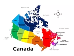
Canada is the 2 nd largest country in the world and has a population of about 35 million people The capital of Canada is Ottawa Ontario Canada stretches from the Pacific Ocean in the west to the Atlantic Ocean in the east and northward into the Arctic Ocean ID: 375508

canada province capital population province canada population capital people provinces territories nunavut region northwest quebec island ontario scotia brunswick

Share:

Link:

Embed:

Download Presentation from below link

Download Presentation The PPT/PDF document "Canada" is the property of its rightful owner. Permission is granted to download and print the materials on this web site for personal, non-commercial use only, and to display it on your personal computer provided you do not modify the materials and that you retain all copyright notices contained in the materials. By downloading content from our website, you accept the terms of this agreement.


Presentation Transcript

Slide1
Slide2

Canada

Canada is the 2

nd largest country in the world and has a population of about 35 million people.The capital of Canada is Ottawa, Ontario.Canada stretches from the Pacific Ocean in the west to the Atlantic Ocean in the east, and northward into the Arctic Ocean.Slide3

Canada

Canada officially became The Dominion of Canada on July 1, 1867, with the four provinces of Ontario, Quebec, New Brunswick and Nova Scotia.Slide4

Atlantic Canada & The Maritimes

Atlantic Canada refers to the three Maritime provinces of New Brunswick, Nova Scotia, and Prince Edward Island, as well as the province of Newfoundland and Labrador.

This region has a variable climate with generally long, cold winters and moist, short summers.Slide5

Prince Edward Island

Prince Edward Island is the smallest province in size and in population.

Charlottetown is the capital of the province.The population of Prince Edward Island is about 145 thousand people.Slide6

Prince Edward Island

Prince Edward Island became part of Canada in the year 1873.Slide7

Nova Scotia

Nova Scotia is found on the east coast and it is the most populated province in Atlantic Canada.

The capital of the province is Halifax.Nova Scotia has a population of about 945 thousand people.Slide8

Nova Scotia

Nova Scotia was one of the four provinces that originally joined Confederation in 1867.Slide9

New Brunswick

New Brunswick is the largest of the Maritime provinces and is located on the east coast.

Fredericton is the capital of the province.New Brunswick has a population of about 750 thousand people.Slide10

New Brunswick

New Brunswick was one of the four provinces that originally joined Confederation in 1867.Slide11

Newfoundland & Labrador

Newfoundland and Labrador is the easternmost province in Canada and includes the island of NFLD and the mainland of Labrador.

The capital of the province is St. John’s.Newfoundland and Labrador has a population of about 515 thousand people.Slide12

Newfoundland & Labrador

Newfoundland & Labrador became part of Canada in 1949.Slide13

Central Canada

Central Canada is the region that refers to Canada’s two largest and most populated provinces of Ontario and Quebec.

The climate mostly ranges from cool, moist areas to more humid areas with warm summers.Slide14

Quebec

Quebec is the largest province in size; only the territory of Nunavut is larger.

Quebec City is the capital of the province.The population of Quebec is about 8 million people.Slide15

Quebec

Quebec was one of the four provinces that originally joined Confederation in 1867.Slide16

Ontario

Ontario is the most populated province and is home to Canada’s national capital, Ottawa.

Toronto is the largest city in Canada and it is the capital of the province.The population of Ontario is about 13 million people.Slide17

Ontario

Ontario was one of the four provinces that originally joined Confederation in 1867.Slide18

Western Canada & The Prairies

Western Canada refers to the four provinces of Manitoba, Saskatchewan, Alberta and British Columbia.

The west coast is generally characterized by mountains and a warm, moist climate, while more inland is known for its dry, flat grasslands called the Prairie provinces.Slide19

Manitoba

Manitoba is the furthest Prairie province from the west coast.

Winnipeg is the capital of the province.The population of Manitoba is about 1.2 million people.Slide20

Manitoba

Manitoba became part of Canada in 1870.Slide21

Saskatchewan

Saskatchewan is one of Canada’s two landlocked provinces because it is surrounded completely by land.

The capital of the province is Regina.Saskatchewan has the smallest population of the Prairies with about 1 million people.Slide22

Saskatchewan

Saskatchewan joined Confederation in 1905.Slide23

Alberta

Alberta is one of Canada’s two landlocked provinces because it has no coastline.

Edmonton is the capital of the province.Alberta has the largest population of the three Prairie provinces with about 3.8 million people.Slide24

Alberta

Alberta became part of Canada in 1905.Slide25

British Columbia

British Columbia is the westernmost province in Canada.

Victoria is the capital of the province.British Columbia has a population of about 4.5 million people.Slide26

British Columbia

British Columbia entered Confederation in 1871.Slide27

The North

The North refers collectively to Canada’s three territories of Yukon, Northwest Territories and Nunavut.

This area is characterized by cold arctic tundra and cool moist climates. Slide28

Yukon

Yukon is the smallest territory in Canada.

Whitehorse is the territory’s capital.Yukon has a population of about 34 thousand people.Slide29

Yukon

Yukon became part of Canada in the year 1898.Slide30

Northwest Territories

The Northwest Territories border Nunavut, Yukon and the Arctic Ocean.

Yellowknife is the capital of the Northwest Territories.The Northwest Territories has a population of about 42 thousand people.Slide31

Northwest Territories

The Northwest Territories became part of Canada in 1870, but its current borders changed with the creation of Nunavut.Slide32

Nunavut

Nunavut is the largest and newest territory.

Iqaluit, located on Baffin Island, is the territory’s capital.Nunavut is a major portion of Northern Canada and has a population of about 32 thousand people.Slide33

Nunavut

Nunavut was separated from the Northwest Territories in 1999 to become its own territory.Slide34
Slide35
Slide36
Slide37
Slide38

Name that ProvinceSlide39

Name that ProvinceSlide40

Name that ProvinceSlide41

Name that ProvinceSlide42

Name that ProvinceSlide43

Name that ProvinceSlide44

Name that ProvinceSlide45

Name that ProvinceSlide46

Name that ProvinceSlide47

Name that ProvinceSlide48

Name that TerritorySlide49

Name that TerritorySlide50

Name that TerritorySlide51

Name that RegionSlide52

Name that RegionSlide53

Name that RegionSlide54

Name that RegionSlide55

Name that RegionSlide56

Name that Region