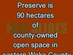
/
Casper Bluff Land and Water Preserve (Jo Casper Bluff Land and Water Preserve (Jo

Casper Bluff Land and Water Preserve (Jo - PDF document

min-jolicoeur
min-jolicoeur . @min-jolicoeur
Follow
415 views
Uploaded On 2015-09-17

Casper Bluff Land and Water Preserve (Jo - PPT Presentation

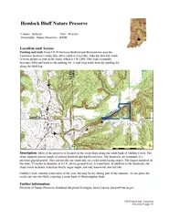
Daviess Conservation Foundation Casper Bluff Land and Water Preserve Jo Daviess Conservation Foundation Cassville Bluffs SNA Abbie Meyer MVC Pikes Peak McGregor Iowa Molly McGuire 28 BIG ID: 131817

Daviess Conservation Foundation) Casper Bluff Land

Share:

Link:

Embed:

Download Presentation from below link

Download Pdf The PPT/PDF document "Casper Bluff Land and Water Preserve (Jo" is the property of its rightful owner. Permission is granted to download and print the materials on this web site for personal, non-commercial use only, and to display it on your personal computer provided you do not modify the materials and that you retain all copyright notices contained in the materials. By downloading content from our website, you accept the terms of this agreement.


Presentation Transcript

Casper Bluff Land and Water Preserve (Jo Daviess Conservation Foundation) Casper Bluff Land and Water Preserve (Jo Daviess Conservation Foundation) Cassville Bluffs SNA (Abbie Meyer, MVC) Pikes Peak, McGregor, Iowa (Molly McGuire) 28 BIG RIVE MAGAZINE / May-June 2009 ILLINOIS WISCONSIN IOWA MINNESOTA ST. CROIX R WIS. R. MINN. R Hastings Prescott Red Wing Maiden Rock Lake City Wabasha Alma Fountain City Trempealeau La Crosse Genoa New Albin De Soto Harper’s Ferry Lynxville Prairie du Chien Dubuque Bellevue Potosi Galena Bay City Minneapolis Frontenac East Dubuque Dakota Brownsville La Crescent Lansing Cassville Nelson Winona St. Paul Marquette McGregor Guttenberg Pepin Stockholm Clinton Fulton Camanche Albany Port Byron Moline Rock Island Le Claire Bettendorf Davenport Savanna Thomson Muscatine Ferryville Glen Haven Wyalusing Sabula Mississippi Palisades SP Spring Lake Park Barn Bluff Memorial Park Frontenac SP John A. Latsch SP Garvin Heights Great River Bluffs SP Apple Blossom Scenic Drive Pikes Peak SP Guttenberg Roadside Overlook Eagle Point Park Bellevue SP Indian Mounds Park Buena Vista Park Perrot SP Miller Bluff Grandad Bluff Dobson Bluff Scenic Overlook Wylusing SP Nelson Dewey SP Gramercy Park Eagle Point Park Effigy Mounds National Monument Mount Hosmer Park Weed Park Mark Twain Overlook Maiden Rock Bluff Ft. Snelling SP Ledebuhr Bluff Hass Bluff Reno Recreation Area Grey Cloud Island SNA Rush Creek SNA Sugar Creek Bluff SNA Devil’s Backbone Cassville Bluff Keough Effigy Land & Water Preserve Casper Bluff Land & Water Preserve Julien Dubuque Monument Pine Bend Bluffs SNA Cherokee Park Eagles Bluff Park Vetsch Park Upper Mississippi Overlooks Minnesota Fort Snelling State Park Highway 55 and Highway 5, Minneapolis Access: a short walk Conuence of Mississippi and Minnesota rivers Indian Mounds Park east of downtown St. Paul Access: drive right up View: airport, bridges, downtown, tows Cherokee Park 700 Cherokee Heights Blvd., St. Paul Access: drive up View: High Bridge, city Pine Bend Bluffs Scientic and Natural Area Inver Grove Heights Access: a short walk View: Upper and Lower Grey Cloud Island, Baldwin Lake, Spring Lake Spring Lake Park: Shaars Bluff 123rd St. E., northwest of Hastings Access: a short walk View: Spring Lake, Lower Grey Cloud Island Grey Cloud Dunes Scientic and Natural Area 110th St, Cottage Grove Access: a short walk View: Lower Grey Cloud Island, channel, bluffs Barn Bluff E. Fifth St., north of Highway 61, Red Wing Access: a walk up the bluff View: islands, city, bridge Memorial Park E. Seventh St. to Skyline Dr., Red Wing Access: drive View: backwaters, bridge, city Frontenac State Park Frontenac Access: a short walk View: Lake Pepin John A. Latsch State Park upriver from Lock & Dam 5 Access: a steep climb View: Whitman Bottoms Garvin Heights left and right at end of Huff St., Winona Access: a short walk View: city, Alma power plant to Trempealeau Mt. Great River Bluffs State Park Dakota Access: a short walk View: Trempealeau to Lake Onalaska Apple Blossom Scenic Drive La Crescent to Dakota Access: drive View: Lake Onalaska Eagles Bluff Park La Crescent Access: a short steep walk View: city, railroad bridge, downriver Vetsch Park end of N. Second St., La Crescent Access: a short walk View: city, backwaters Reno Recreation Area Access: a walk up the bluff View: Reno Backwaters, Pool 8 Iowa Mount Hosmer Park Lansing Access: a short walk View: bridge and backwaters Efgy Mounds National Monument between Harpers Ferry and Marquette Access: a walk up the bluff View: river, islands, Prairie du Chien Pikes Peak State Park downstream from McGregor Access: a short walk View: conf. Mississippi and Wisconsin rivers Guttenberg Roadside Overlook Highway 52 south of Guttenberg Access: pull over View: city, river valley, backwaters Eagle Point Park upstream side of Dubuque Access: a short walk View: Lock & Dam 11, Pool 11 Julien Dubuque Monument Mines of Spain State Recreation Area, Dubuque Access: a short walk View: islands, river valley Bellevue State Park downstream side of Bellevue Access: a short walk View: backwaters of the former Savanna Army Depot Eagle Point Park upstream side of Clinton Access: a short walk View: Lock & Dam 13, Pool 13 Weed Park upstream side of Muscatine Access: drive up View: river valley Mark Twain Overlook upstream side of bridge, Lombard St., Muscatine Access: short drive up steep street View: bridge, river, downtown Wisconsin Maiden Rock Bluff State Natural Area ridge between Stockholm and Maiden Rock Access: a moderate walk View: Lake Pepin, Frontenac Buena Vista Park Alma Access: a short walk or walk up the bluff from town View: city, Lock and Dam 4, backwaters Ledebuhr Bluff 1 mile upstream from bridge to Winona (Hwys 35 & 54 intersection) Access: a walk up the bluff View: Winona, Prairie Island, river and backwaters Perrot State Park: Brady’s Bluff upriver from Trempealeau Access: a walk up the bluff View: sandbars, steep bluffs in Minnesota Miller Bluff end of Rim of the City Rd. or via TNT Trail from Hixon Forest, La Crosse Access: a moderate walk or a climb up the bluff View: La Crosse, marsh, backwaters, Genoa Grandad Bluff Bliss Rd., La Crosse Access: a short walk View: city, marsh, river Dobson Bluff end of Thistledown Dr., La Crosse Access: a short walk View: city, wooded valley and bluffs, river Hass Bluff rst switchback curve on Easter Rd., La Crosse Access: a long walk up the bluff View: south La Crosse, backwaters, La Crescent Scenic Overlook 2 miles upriver from Genoa Access: a short walk View: Lock & Dam 8, Brownsville Rush Creek State Natural Area path across the road from parking area, between De Soto and Ferryville Access: a walk up the bluff View: middle Pool 9, Iowa bluffs Sugar Creek Bluff State Natural Area downriver from Ferryville, Access: a walk up the bluff or a short walk View: lower Pool 9, Iowa bluffs Wyalusing State Park: Point Lookout Wyalusing Access: a short walk View: conf. of Mississippi and Wisconsin rivers Devil’s Backbone State Natural Area park near where Dugway Rd. crosses Chase Creek, upriver from Glen Haven Access: a short, steep hike View: river, backwaters, islands Nelson Dewey State Park upriver from Cassville Access: drive right up View: native prairie, backwaters Cassville Bluffs State Natural Area park at the end of Sand Lake Ln., south of Cassville Access: a long walk up the bluff View: backwaters, Main Channel, Iowa bluffs Illinois Gramercy Park East Dubuque Access: a short walk View: city, Dubuque, bridge Keough Efgy Mound Land and Water Pre - serve (may open this year) end of North Cross Rd., southwest of Galena Access: a moderate walk View: Keogh Slough, Iowa bluffs Casper Bluff Land and Water Preserve 870 S. Pilot Knob Rd., south of Galena Access: a very short walk View: Harris Slough, Bellevue Mississippi Palisades State Park upriver from Savanna Access: moderate walks View: backwaters 30 BIG RIVE MAGAZINE / May-June 2009