/
2017 PISCO  UCSC Invertebrate and Algae 2017 PISCO  UCSC Invertebrate and Algae

2017 PISCO UCSC Invertebrate and Algae - PowerPoint Presentation

mitsue-stanley
mitsue-stanley . @mitsue-stanley
Follow
345 views
Uploaded On 2019-06-21

2017 PISCO UCSC Invertebrate and Algae - PPT Presentation

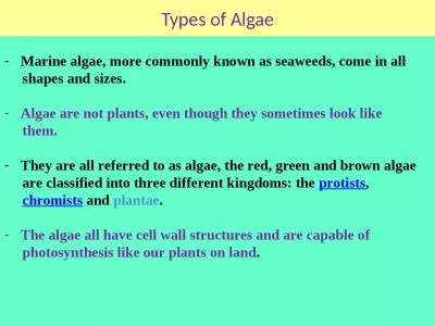
Sampling Methods Overview of todays training PISCO Annual Survey Design Swath survey method UPC method B enthic transect protocol Organism ID slides Annual Survey Design When June ID: 759564

upc surveys swath transect surveys upc transect swath data diver tape point iii depth algae meter superlayer sand substrate amp segment mark

Share:

Link:

Embed:

Download Presentation from below link

Download Presentation The PPT/PDF document "2017 PISCO UCSC Invertebrate and Algae" is the property of its rightful owner. Permission is granted to download and print the materials on this web site for personal, non-commercial use only, and to display it on your personal computer provided you do not modify the materials and that you retain all copyright notices contained in the materials. By downloading content from our website, you accept the terms of this agreement.


Presentation Transcript

Slide1

2017 PISCO

UCSC

Invertebrate and Algae

Sampling

Methods

Slide2

Overview of today’s training

PISCO Annual Survey Design

Swath survey method

UPC methodBenthic transect protocolOrganism ID slides

Slide3

Annual Survey Design

When:

June

– September

1999

– present

Where:

Different oceanographic regimes

Lower upwelling – southern Monterey Bay

Higher upwelling – Point Lobos, Carmel Bay

Marine Protected Areas and paired comparison sites

Lover’s Point SMR, Ed Ricketts SMCA, Pacific Grove Marine Gardens SMCA

Point Lobos SMR,

Pescadero

Point,

Soberanes

Slide4

Pacific Grove Marine Gardens SMCA

100m buffer from reserve boundary

Asilomar SMR

Existing PISCO long term monitoring unit

New randomly selected monitoring unit

89

99

02 Composite Kelp

2005 Kelp

Benthic transects at 5, 12.5 and 20m

Fish transects at 5, 10, 15 and 20m

Example

of permanent, stratified

random

sampling design

Slide5

T

ransects: 30 m (n=3 per depth)

D

epths: 5

, 10, 15 & 20 mTotal = 12 transects per Area

D

epth

-stratified sampling

design: fishes

Slide6

Benthic transects: 30 m (n=2 per depth)

Transect depths: 5, 12.5 & 20 m

Depth

-stratified sampling

design: inverts & algae

Slide7

……

Time

Sites

Cells

Zones

(5

, 12.5 , & 20 m)

1999

20??

1

2

?

3

1

2

S

D

Transects:(n=2)

……

Annual Benthic Surveys – Nested Hierarchy

M

1

Slide8

Annual

Benthic Surveys: Depth Stratification

Depth zones:

Shallow (S) = 5 m, Mid (M) = 12.5 m, Deep (D) = 20 m

designed to assure that all depth zones are representatively sampled for description of invert and algae assemblages.

2

.

Allows representative sampling from outer to inner edges of the

reef

.

If reef depths are constrained (e.g., 5-10 m), then sampling is distributed from outer to inner edges of reef including comparable depths (when possible) to those above (e.g., 5 and 10 m), plus additional depth strata to assure coverage from inner to outer edges of the reef.

Note that divers descend at known GPS locations, not where kelp is present or not. In some years, the kelp is very thick, and in others it can be absent. We have GPS points to tell us where to go for each depth zone and we return to them year after year.

Slide9

Algae/invertebrate transect distribution

Coastline

5 m

(shallows)

12.5

m

(

mids)

20

m

(deeps)

Zone

Upcoast

cell

Downcoast

cell

North

Annual

Benthic Surveys

:

Depth Stratification

Slide10

Slide11

PISCO-UCSC divers use three methods: (1) Uniform point contact (UPC) to estimate percent cover of benthic organisms and to characterize the substrate(2) Swath transects to estimate the density of kelps and targeted macroinvertebrates(3) Size frequencies of abalone and urchins (AbU)

Annual

Benthic Surveys

:

Methods

Slide12

Priorities: reef > depth > heading- If your pre-designated compass heading will take you off reef, make a systematic deviation and maintain the new heading for the remainder of the transect.- Maintain constant depth (continuously watching depth gauge) by contouring around large rocks and avoid stringing the transect tape over very large crevices. - Use kelp, rocks, etc. to wrap/anchor the transect tape along the bottom.**If you ever complete a transect and feel that something was “off”, speak up. We can always re-do transects.**

Annual

Benthic Surveys

:

reeling tapes out

Slide13

Do not lay tape with high tension

Lay tape so it generally contours bottom

Annual

Benthic Surveys

:

tape tension

Slide14

1 m

Side view of reef with red tape: too taut

Annual

Benthic Surveys

:

tapes and crevices

Less tension on red tape

Slide15

Swaths should extend

one meter on either side of the transect line.

Swath Surveys: 2 m wide

Maintain reasonable speed (~20 minutes per transect) and only count invertebrates 2.5 cm or larger in diameter (except urchins and certain sea stars)

Top view of transect

Transect line

1 meter

1 meter

Slide16

1

m is measured by diver extending arm and moving body over line to the point on chest where 1 m ends.Each diver must know where on their body 1 meter from the tip of their fingers stops (endpoint). This is often near armpit, but it varies.

Swath Surveys: 1 m body measurement

Slide17

End-on view of

transect —

tape (red dot)

is into and out of slide

Transect tape

Diver uses “arm to endpoint” to measure 1 m on either side of the transect tape.

Swath

Surveys: swath width

1 m

1 m

1 m

1 m

Slide18

Use a flashlight at all times when surveying for swath invertebrates to make sure organisms in cracks andcrevices are counted

Swath Surveys: mandatory flashlights

Slide19

Transect tape(into/out screen)

Reef

1m

1m

Flat

1m

1m

Crevice

1m

1m

Swath

Surveys: search area

Flat and vertical

Slide20

1m

1m

1m

1m

1m

1m

Transect tape

(into/out screen

)

Reef

Ridge

Overhang

Wall

Green line indicates area searched

Slide21

Cover

symmetric sides when

subsampling

Sub-sampling protocol: proper counting

Slide22

30 29 28 27 26 25 24 23

For

a

sub-sample

, record the distance sampled within the 10 m segment to the nearest 0.1 m.

Example: this

diver started at 30 m and counted 33

Pterygophora

by the 26.2 m mark, thereby sampling a rectangle 3.8 m long.

Record this as: 33 @ 3.8 m.

Distance covered, not meter mark

Slide23

Swath Surveys: invert data sheet

Siren

7-23-17

330

Lonhart

Malone

36’-34’

Four genera are counted and three genera are measured:

Count =

Patiria

,

Dermasterias

,

Henricia

, &

Mediaster

Measure =

Pisaster

,

Pycnopodia

and

Orthasterias

.

Slide24

Measure length (nearest cm) for TARGET sea stars encountered in the 2 m wide swath.Measure along the aboral surface, from the center of the medial disc to the tip of the single longest ray.Remove the star if easy to do, otherwise measure in place.Note disease status (* = mild, ** = dissolving)

Sea star measurement

Slide25

When measuring, follow the curve of the longest ray

Slide26

1 2 3 4 5 6 7

1 2 3 4 5 6 7

1 2 3 4 5 6 7

Measure to the nearest cm (without bias)

Slide27

Note health

status for sea stars: * = mild disease ** = severe *(II, 3, E) translates to 16 bat stars that display signs at mild stage of diseaseSwath diver measures sea star ray length for certain species.

Sea star disease and recording

III, 7, 5, **(2,I)

II, 2, E, *(II, 2)

7, 12, E, 8*, 10, 14** 8(III, 3) 8*

3,

7

, E, 5*

Ortkoe

5, 9,

Slide28

Swath Surveys: invert data sheet

These species must be

≥2.5 cm diameter/length

Slide29

Swath Surveys: invert data sheet

Do not forget the write-ins:

Anthopleura

xanthogrammica = giant green anemone, no lines on oral discMetridium spp. = white anemones, giant plumose anemone (M. farcimen)Lytechinus pictus = white urchin, has brown patchesAplysia californica = red sea hareAplysia vaccaria = black sea hareMegastrea undosa = wavy turban snail (never been seen)Loxorhynchus grandis = sheep crab, greenish, spines, few epibiontsNeobernaya spadicea = chestnut cowry

These species must be

≥2.5 cm diameter/length

Slide30

Swath Surveys: recording observations

III

III, 7, 22

III

I

I

I, 4, IIIIII, E

IIIIIII

If you ever want to write the number eleven, do not write II, instead use E. There is no eleven other than E. Anything else is “2”.

Slide31

Swath Surveys: recording observations

III

III, 7, 22

III

I, 4, IIIIII, E

Prior to next dive, translate and sum your data in each row and circle that number. Overall total on extreme right.

IIIIIII

IIIIIII

II

I

I

32

22

3

7

12

Slide32

Count

all individuals >30 cm, except Macrocystis and Nereocystis (>1 m) and Cystoseira (>6 cm diameter).

>

6 cm

1 m

Efird

Swath Surveys: kelp counts

Slide33

Swath Surveys: recording data

Record # of

stipes

for each individual Macrocystis, separate with commasRecord number of NereocystisCount stipes of Pterygophora, Eisenia, L. setchellii, & PleurophycusSum all non-Macrocystis counts upon surfacing

1, 3, 37, 15, 8, 5, 2, 45

III, 4, 2, III III I

III, 12, E 32 @ 4.3 m

2, 4, 6, 2, 14, 5, 2 @ 6.3 m

III, E, 2, III

Fuller’s

8-17-17

330

Lonhart

Carr

38’-30’

16

19

35 @ 6.3 m

Slide34

Slide35

UPC Surveys: tape meter marks

Slide36

Data collected every 1 m on a 30 m transect tape

Transect tapes are marked at 1 m increments. Every 10 m segment has a single color of tape at each 1-m mark.Be sure to count 10 points per segment. For example, if you start at 30 m mark you stop at 21 m mark, and 20 is your next segment’s starting point, thus you finally end at 1 m mark and not 0 m (30 to 1). If you start at 29 m, you end at 20 m, and at end of tape, end at 0 m mark (29 to 0).0-9 is ten digits, just like 1-10 is ten digits. Think about it….

UPC Surveys: tape meter marks

1

meter increments

10-m segment

Slide37

Remember not to bias your data!

Look once and pick the point, do not “look around.”

UPC Surveys: tape to bottom

Slide38

Substrate

Relief

Point

(cover)

Superlayer

(special category)

UPC Surveys: 30+ counts per 10 m

Slide39

Substrate type

Barlotti

UPC Surveys: substrate

Slide40

Sand can be substrate (Sand) and a point (Bare sand category)What happens when bedrock has a pocket of sand?If the point lands on a pocket of sand that cannot be waved away with the brush of a hand, but you can poke your finger into the sand and touch the rock under it, then Substrate = Bedrock and Point = Bare sandIf the pocket of sand is deep enough that you cannot touch the rock under it, it is potential habitat, so then Substrate = Sand and Point = Bare sandIf you are on bedrock and come across a sand-filled crevice full of Diopatra, and your point hits the worm, then Substrate = Sand and Point = Diopatra

UPC Surveys: sand vs. bare sand

Slide41

If your point falls on a mobile invertebrate or epibiont, ignore it and make sure you are recording the organism underneath it that is directly attached to the substrate!(Note, it need not be attached under the point, elsewhere is ok)

Lonhart/MBNMS

Colonial tunicate

on a solitary tunicate

UPC Surveys: ignore epibionts

Slide42

A

B

C

Sponge

Red

branching

Green

algae

UPC Surveys: ignore epibionts

Slide43

Figurski

Figurski

Drift algae and juvenile

laminariales

(e.g., <30 cm tall Laminaria, Eisenia, Macrocystis, Pterygophora) can be the first thing you encounter at your point. Record the superlayer, move it aside and then record the primary substrate holder.

UPC Surveys:

superlayer

Slide44

A

B

C

Sponge

Red

branching

Red branching and

superlayer

if

it is a juvenile

laminariales

If

it is not a juvenile

laminariales

then it

is either

Cystoseira*

,

Dictyota

,

Desmarestia

,

Sargassum

spp. or

Other

Brown

UPC Surveys: epibionts &

superlayer

Slide45

UPC Surveys:

superlayer species or not?

Laminariales generain central California:LaminariaCostariaPleurophycusEgregiaEiseniaAlariaPterygophoraMacrocystisNereocystisDictyoneuropsis / Dictyoneurum

Non-

laminariales

genera

t

hat are brown and

in central California:

Cystoseira

Dictyota

Desmarestia

Sargassum

Other Brown

Slide46

UPC Surveys: ID

superlayer spp.

Key is to determine

what this is!

Juvenile

Nereocystis

above, and likely juvenile

Macrocystis

below it

Slide47

UPC Surveys: ID

superlayer spp.

Key is to determine

what this is!

Juvenile

Eisenia

arborea

Slide48

UPC Surveys: ID

superlayer spp.

Key is to determine

what this is!

Juvenile

Macrocystis pyrifera

Slide49

UPC Surveys: ID

superlayer spp.

Key is to determine

what this is!

Adult

Dictyoneurum

/

Dictyoneuropsis

, and therefore it is NOT a

superlayer

.

Slide50

Relief is the absolute difference in elevation between the highest and lowest point within a 1 m by 0.5 m rectangle

Top view of transect

1 meter

0.5 meter

UPC Surveys: determining relief

0 m

Slide51

Relief is determined within non-overlapping rectangles (1 m by 0.5 m) as depicted below

0.5 m

Top view of transect

The rectangle is centered on the UPC point. Each rectangle extends 0.5 m on both sides of the tape, and 0.25 m in front of and behind the point along the tape.

1 meter

0

1

2

UPC Surveys:

determining relief

Slide52

0.5 m

Top view of transect

1 meter

0

1

2

UPC Surveys:

determining relief

Imagine the rectangle is suspended above the bottom, as if it had been lowered from the surface and was perfectly level.

Within

each rectangle find the

highest and lowest points, then determine the vertical distance between the two.

Slide53

End-on view of transects

Find the high and low points in each rectangle. Remember it is 0.5 m to either side of the meter mark, and 0.25 m in front and behind it.

UPC Surveys: high and low points

0.5 meter

Slide54

Relief is binned into four categories. Basically they are: flat, knees to head, standing, and wall. 0-0.1 m 0.1-1 m 1-2 m >2 m

UPC Surveys: relief categories

Slide55

At the end of the 30 m you should have 30 points in 3 categories (i.e. substrate, relief, and point—90 total) and possibly some superlayer data.

Substrate

Relief

Point

Superlayer

(special category)

sand, cobble, boulder, bedrock

0-0.1, 0.1-1, 1-2, >2 m

Drift or juvenile laminariales

What was under the point, live or dead

UPC Surveys: review

Slide56

UPC Surveys: recording data

Hopkins

7-23-17

330

Lonhart

Saarman

16’-14’

IIII II

II II II

IIIIIIIIII

II II

II II

2 4 1 2 2

4 1 2 2 2 2 2 4

I I I II I I I

I I I I I I I

I I

II II I III

2

I 2

I

Did you find the error?

Slide57

UPC Surveys: summing rows

Hopkins

7-23-17

330

Lonhart

Saarman

16’-14’

IIII II

II II II

IIIIIIIIII

II II

II II

2 4 1 2 2

4 1 2 2 2 2 2 4

I I I II I I I

I I I I I I I

I I

II II I III

2

I 2

Between dives, sum all rows and circle total at right.

22

4

4

E

19

8

3

7

10

Slide58

Slide59

Count abalone and purple & red urchins on the swath transect (2 m x 30 m) in 10 m segments.Use flashlight to look in crevices.Count and size (cm) what you can see.Record to nearest cm.Sub-sample urchin species if 30 counted, pooling across all size classes in that segment.

Ab

alone & Urchin surveys

Slide60

Measure greatest shell length (nearest cm) for each abalone encountered in the 2 m wide swath.Urchin diameter is for the test (i.e. shell) and does not include the spines.

Ab

alone & Urchin sizing

Slide61

Length

Greatest shell length for abalone

Slide62

Diameter

Slide63

AbU

Surveys: recording data

McAbee

9-8-

17

270

Lonhart

Vylet

46’-50’

I, 4, II, 4, IIII, 2, 2, III)

III

IIIII, 5, 3, IIII

5 (II, 2, 4) @ 7.3 m

III

33

Slide64

Slide65

2017 Benthic Transect Protocol

Three diver system: UPC diver,

swath diver, and AbU diver

There will be three divers. In addition to UPC (black) and swath (

green

) divers, there is also an abalone-urchin (

purple

) diver, aka

AbU

.

The

AbU

diver collects size-frequency data for both red and purple urchins as well as three abalone species.

Slide66

Phase 1: Reeling out

transect #1

Swath diver reels out tape, follows heading but maintains target depth;The UPC diver collects data;The AbU diver collects data while following UPC.

Slide67

Phase 2:

Heading to 0 m on transect 1

Swath

diver

secures tape, then starts

counting swath inverts;

UPC diver reaches end of tape, heads back to 0 m counting swath algae;

The

AbU

diver

reaches end of tape and reels it in, making sure both

swath

and UPC are ahead;

Always check

in

with buddies as

you pass.

Slide68

Phase

3: Reeling out transect #2

Swath diver reels out tape, follows heading but maintains target depth;The UPC diver collects data, transitioning from tape #1 to #2;The AbU diver collects data while following UPC.

Slide69

Phase

4:

Swath algae

data on transect 2

If the

swath

diver is done collecting invert data on transect #2, then that diver is now at the 0 m end

.

The

swath

diver

can collect swath algae data from 0 m out to the end of transect #2.

The UPC diver may be working back from the 30 m end of transect #2, also counting swatch algae. When

they meet, they

ensure that the area between them is counted.

If

the

swath

diver is still on

inverts and passed by the UPC diver, then the

UPC

diver finished algae on transect #2.

The

AbU

diver reels in the tape since they are typically slowest

.

Slide70

Ideal scenario for

s

wath

algae on transect 2

Slide71

Slide72

Within each 10 m segment, if you reach 30 or more individuals of a single species, note how many were counted followed by the distance covered (e.g., 32 at 2.7 m). M. pyrifera excluded.You start over in the next 10 m segment.Be sure to finish the entire ‘rectangle’ so we capture an accurate density estimate.

Sub-sampling reminder!

Slide73

Within each 10 m segment, once ≥30

individuals of a species are counted, indicate the distance you sampled within that 10 m segment (NOT THE METER MARK!) and stop counting that particular species until you reach the next 10 m segment.

For example, if you count 34

Styela from the 20 m mark to the 17.5 m mark, then you record that as “34 @ 2.5 m” on the data sheet.Be sure to count all individuals in the rectangle you sample, even if it is slightly over 30, since density estimates are based on a rectangular area.Count all Macrocystis.

Sub-sampling protocol: 10 m segment

Slide74

Safety Considerations

Dive profiles

- approved by DSO

- well within no-decompression limits

- maximum depth 20 m

- 3-5 min safety stops mandatory on dives >10 m

Air consumption

- safety over data collection (500 psi @ surface)

Buddy system

- members of a dive team are always in contact via the transect line

Sea conditions

- diving will only be conducted in good conditions

Slide75

Dive Safety Brief

1. Dive log - sign out and in

2. Dive procedures - ascent rate 1 ft per 2 sec - deep-shallow - maintain dive team3. On board communications: cell phone, VHF Ch 16 (Paragon), & SPOT system4. First Aid & Oxygen - Shore and vessel5. Evacuation plan: this is developed for each site and must be covered prior to the dive

Slide76

Locations of CHOMP and PG chamber

Slide77

Locations of LML, the SC harbor and Dominican Hospital

Slide78

Slide79

Slide80

5. Collect algae data

Transect 2

Transect 1

AbU

Invert

UPC

0

0

30

30

1. Reel out

1. Collect data

1. Collect data

4. Collect data

4. Reel in

4. Collect algae data

2

. Collect data

3. Reel out

2

. Collect algae data

2

. Reel in

3. Collect data

3. Collect data